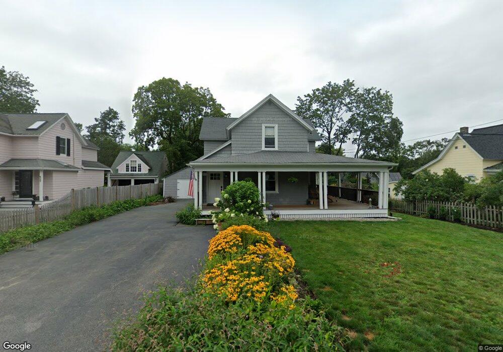
68 Crest St Unit 68 Concord, MA 01742
Estimated Value: $936,000 - $1,065,092
3
Beds
2
Baths
1,390
Sq Ft
$716/Sq Ft
Est. Value
About This Home
This home is located at 68 Crest St Unit 68, Concord, MA 01742 and is currently estimated at $995,273, approximately $716 per square foot. 68 Crest St Unit 68 is a home located in Middlesex County with nearby schools including Willard School, Concord Middle School, and Concord Carlisle High School.
Ownership History
Date
Name
Owned For
Owner Type
Purchase Details
Closed on
Dec 11, 2020
Sold by
Campbell Lorna R and Sharp Christopher H
Bought by
Hinkle Joseph R
Current Estimated Value
Home Financials for this Owner
Home Financials are based on the most recent Mortgage that was taken out on this home.
Original Mortgage
$450,000
Outstanding Balance
$401,349
Interest Rate
2.8%
Mortgage Type
New Conventional
Estimated Equity
$593,924
Purchase Details
Closed on
Dec 12, 2014
Sold by
Campbell Joan and Campbell Lorna R
Bought by
Campbell Lorna R and Sharp Christopher H
Purchase Details
Closed on
Mar 5, 2013
Sold by
Lunker Rt
Bought by
Campbell Joan and Campbell Loran R
Purchase Details
Closed on
Mar 2, 1998
Sold by
Anderson John H Est
Bought by
Lunker Rt
Home Financials for this Owner
Home Financials are based on the most recent Mortgage that was taken out on this home.
Original Mortgage
$130,000
Interest Rate
6.85%
Mortgage Type
Purchase Money Mortgage
Create a Home Valuation Report for This Property
The Home Valuation Report is an in-depth analysis detailing your home's value as well as a comparison with similar homes in the area
Home Values in the Area
Average Home Value in this Area
Purchase History
| Date | Buyer | Sale Price | Title Company |
|---|---|---|---|
| Hinkle Joseph R | $810,000 | None Available | |
| Campbell Lorna R | -- | -- | |
| Campbell Joan | $484,900 | -- | |
| Lunker Rt | $130,000 | -- |
Source: Public Records
Mortgage History
| Date | Status | Borrower | Loan Amount |
|---|---|---|---|
| Open | Hinkle Joseph R | $450,000 | |
| Previous Owner | Lunker Rt | $200,000 | |
| Previous Owner | Lunker Rt | $130,000 |
Source: Public Records
Tax History Compared to Growth
Tax History
| Year | Tax Paid | Tax Assessment Tax Assessment Total Assessment is a certain percentage of the fair market value that is determined by local assessors to be the total taxable value of land and additions on the property. | Land | Improvement |
|---|---|---|---|---|
| 2025 | $129 | $974,900 | $527,000 | $447,900 |
| 2024 | $12,579 | $958,000 | $527,000 | $431,000 |
| 2023 | $10,807 | $833,900 | $479,100 | $354,800 |
| 2022 | $11,395 | $772,000 | $383,300 | $388,700 |
| 2021 | $10,232 | $695,100 | $383,300 | $311,800 |
| 2020 | $9,746 | $684,900 | $383,300 | $301,600 |
| 2019 | $9,192 | $647,800 | $372,100 | $275,700 |
| 2018 | $8,591 | $601,200 | $354,400 | $246,800 |
| 2017 | $8,280 | $588,500 | $337,600 | $250,900 |
| 2016 | $7,784 | $559,200 | $337,600 | $221,600 |
| 2015 | $7,316 | $512,000 | $312,600 | $199,400 |
Source: Public Records
Map
Nearby Homes
- 1053 Main St
- 16 Concord Greene Unit 5
- 12 S Meadow Ridge Unit 12
- 12 S Meadow Ridge
- 24 Concord Greene Unit 7
- 111 Central St
- 114 Upland Rd
- 29 Concord Greene Unit 3
- 102 Highland St
- 54 Maple St
- 70 McCallar Ln
- 79-81 Assabet Ave
- 855 Barretts Mill Rd
- 1687 Main St
- 37 Wolf Pine Way
- 602 Main St
- 497 Old Road to 9 Acre Corner
- 88 Wright Rd
- 10 Wright Rd
- 70 Hillside Ave