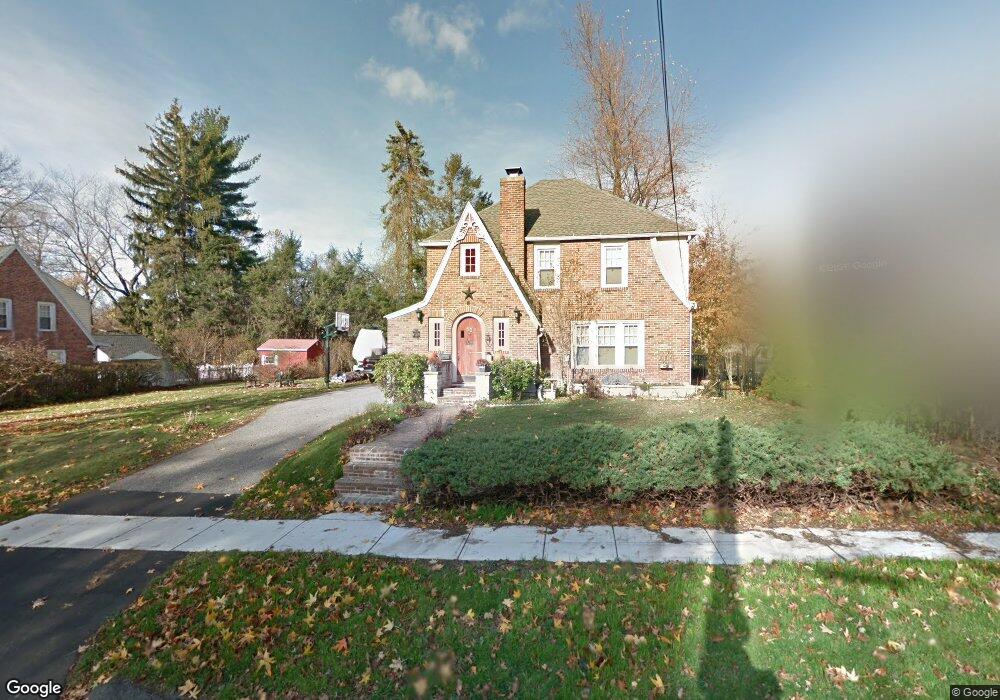
68 Elmwood Ave Longmeadow, MA 01106
Estimated Value: $396,000 - $440,000
3
Beds
2
Baths
1,555
Sq Ft
$270/Sq Ft
Est. Value
About This Home
This home is located at 68 Elmwood Ave, Longmeadow, MA 01106 and is currently estimated at $419,180, approximately $269 per square foot. 68 Elmwood Ave is a home located in Hampden County with nearby schools including Center Elementary School, Williams Middle School, and Longmeadow High School.
Ownership History
Date
Name
Owned For
Owner Type
Purchase Details
Closed on
May 31, 1996
Sold by
Nurse James K and Nurse Michelle J
Bought by
Mailman Kurt A and Mailman Marla
Current Estimated Value
Purchase Details
Closed on
Sep 30, 1994
Sold by
Perrone Belle F
Bought by
Nurse James K
Purchase Details
Closed on
Oct 20, 1988
Sold by
Kusiak Anthony E
Bought by
Perrone Belle F
Create a Home Valuation Report for This Property
The Home Valuation Report is an in-depth analysis detailing your home's value as well as a comparison with similar homes in the area
Home Values in the Area
Average Home Value in this Area
Purchase History
| Date | Buyer | Sale Price | Title Company |
|---|---|---|---|
| Mailman Kurt A | $166,000 | -- | |
| Nurse James K | $153,000 | -- | |
| Perrone Belle F | $165,000 | -- |
Source: Public Records
Mortgage History
| Date | Status | Borrower | Loan Amount |
|---|---|---|---|
| Open | Perrone Belle F | $160,500 | |
| Closed | Perrone Belle F | $158,000 |
Source: Public Records
Tax History
| Year | Tax Paid | Tax Assessment Tax Assessment Total Assessment is a certain percentage of the fair market value that is determined by local assessors to be the total taxable value of land and additions on the property. | Land | Improvement |
|---|---|---|---|---|
| 2025 | $7,626 | $361,100 | $154,400 | $206,700 |
| 2024 | $7,468 | $361,100 | $154,400 | $206,700 |
| 2023 | $6,988 | $304,900 | $133,000 | $171,900 |
| 2022 | $6,978 | $283,200 | $133,000 | $150,200 |
| 2021 | $6,719 | $271,600 | $126,700 | $144,900 |
| 2020 | $6,404 | $264,500 | $119,600 | $144,900 |
| 2019 | $5,921 | $245,800 | $119,600 | $126,200 |
| 2018 | $6,039 | $248,100 | $143,300 | $104,800 |
| 2017 | $5,850 | $248,100 | $143,300 | $104,800 |
| 2016 | $5,640 | $231,800 | $130,600 | $101,200 |
| 2015 | $5,532 | $234,200 | $129,400 | $104,800 |
Source: Public Records
Map
Nearby Homes
- 50 Elmwood Ave
- 58 Englewood Rd
- 55 Fernleaf Ave
- 83 Bliss Rd
- 102 Greenacre Ave
- 170 Hopkins Place
- 55 Dover Rd
- 114 Park Dr
- 642 Laurel St
- 2 Sabrina Way Unit D
- 124 Tecumseh Dr
- 0 Dennis Rd
- 70 Tennyson Dr
- 141 Longfellow Dr
- 418 Meadow St Unit E1
- 283 Longhill St
- 153 Porter Lake Dr Unit 153
- 35 Spruceland Ave
- 34 Regency Park Dr
- 112 Grassy Gutter Rd
- 80 Elmwood Ave
- 64 Elmwood Ave
- 77 Briarcliff Rd
- 84 Elmwood Ave
- 63 Briarcliff Rd
- 67 Elmwood Ave
- 75 Elmwood Ave
- 61 Elmwood Ave
- 83 Elmwood Ave
- 87 Briarcliff Rd
- 92 Elmwood Ave
- 53 Briarcliff Rd
- 51 Elmwood Ave
- 93 Elmwood Ave
- 140 Warren Terrace
- 144 Warren Terrace
- 44 Elmwood Ave
- 44 Elmwood Ave Unit 44
- 148 Warren Terrace
- 128 Warren Terrace
Your Personal Tour Guide
Ask me questions while you tour the home.