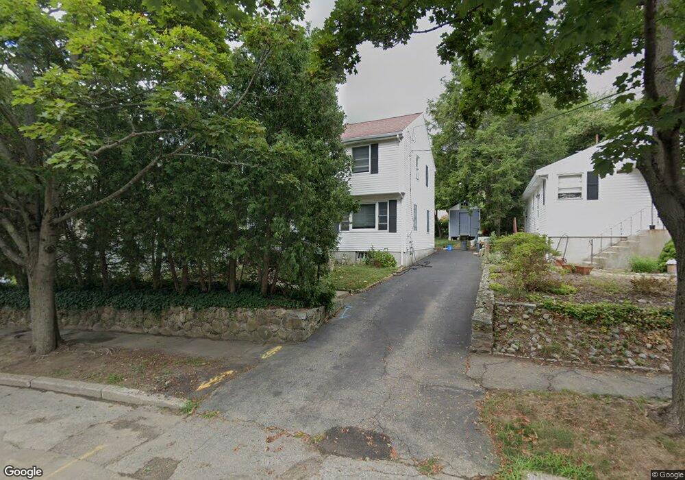
68 Jennings Rd Waltham, MA 02451
Highlands NeighborhoodEstimated Value: $962,000 - $1,030,000
4
Beds
3
Baths
2,477
Sq Ft
$402/Sq Ft
Est. Value
About This Home
This home is located at 68 Jennings Rd, Waltham, MA 02451 and is currently estimated at $994,791, approximately $401 per square foot. 68 Jennings Rd is a home located in Middlesex County with nearby schools including Thomas R Plympton Elementary School, John F Kennedy Middle School, and Waltham Sr High School.
Ownership History
Date
Name
Owned For
Owner Type
Purchase Details
Closed on
Jul 26, 2002
Sold by
Hervagault Jacques A
Bought by
Lin Dong Shou
Current Estimated Value
Home Financials for this Owner
Home Financials are based on the most recent Mortgage that was taken out on this home.
Original Mortgage
$240,000
Outstanding Balance
$102,862
Interest Rate
6.73%
Mortgage Type
Purchase Money Mortgage
Estimated Equity
$891,929
Purchase Details
Closed on
Oct 5, 1998
Sold by
Tuccero Lorraine A
Bought by
Hervagault Jacques A
Home Financials for this Owner
Home Financials are based on the most recent Mortgage that was taken out on this home.
Original Mortgage
$192,000
Interest Rate
6.89%
Mortgage Type
Purchase Money Mortgage
Create a Home Valuation Report for This Property
The Home Valuation Report is an in-depth analysis detailing your home's value as well as a comparison with similar homes in the area
Home Values in the Area
Average Home Value in this Area
Purchase History
| Date | Buyer | Sale Price | Title Company |
|---|---|---|---|
| Lin Dong Shou | $401,000 | -- | |
| Hervagault Jacques A | $240,000 | -- |
Source: Public Records
Mortgage History
| Date | Status | Borrower | Loan Amount |
|---|---|---|---|
| Open | Lin Dong Shou | $240,000 | |
| Previous Owner | Hervagault Jacques A | $192,000 | |
| Previous Owner | Hervagault Jacques A | $50,000 |
Source: Public Records
Tax History
| Year | Tax Paid | Tax Assessment Tax Assessment Total Assessment is a certain percentage of the fair market value that is determined by local assessors to be the total taxable value of land and additions on the property. | Land | Improvement |
|---|---|---|---|---|
| 2025 | $7,875 | $801,900 | $377,700 | $424,200 |
| 2024 | $7,678 | $796,500 | $377,700 | $418,800 |
| 2023 | $7,574 | $733,900 | $342,700 | $391,200 |
| 2022 | $7,746 | $695,300 | $321,700 | $373,600 |
| 2021 | $4,807 | $640,100 | $293,700 | $346,400 |
| 2020 | $7,154 | $598,700 | $265,900 | $332,800 |
| 2019 | $6,887 | $544,000 | $265,900 | $278,100 |
| 2018 | $4,290 | $496,900 | $246,200 | $250,700 |
| 2017 | $5,960 | $474,500 | $223,800 | $250,700 |
| 2016 | $5,722 | $467,500 | $216,800 | $250,700 |
| 2015 | $5,824 | $443,600 | $202,800 | $240,800 |
Source: Public Records
Map
Nearby Homes
- 69 Jennings Rd
- 20 Jennings Rd
- 37 Upland Rd
- 103-105 Columbus Ave
- 28 Galen St
- 23 Palmer St Unit 1
- 43-45 Wellington St Unit 3
- 25 Wellington St Unit 1
- 50 Hammond St
- 43 Leonard St
- 19 Everett St Unit 2
- 291-293 School St
- 15 Howard St
- 90-96 Bacon St
- 32 Vernon St
- 7 Pearl St
- 39 Floyd St Unit 2
- 74 Harvard St
- 50 Worcester Ln
- 16 Winter St Unit 26C
Your Personal Tour Guide
Ask me questions while you tour the home.