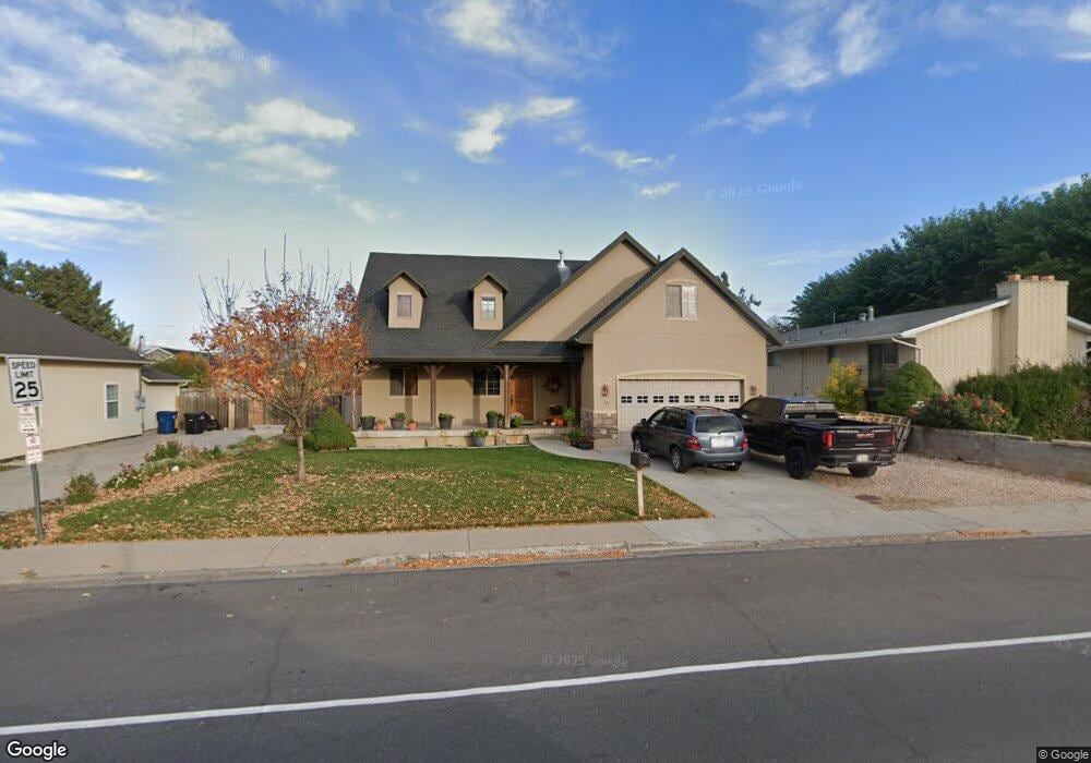
68 N 300 W Unit 617 Spanish Fork, UT 84660
Estimated Value: $526,000 - $672,000
5
Beds
3
Baths
2,231
Sq Ft
$265/Sq Ft
Est. Value
About This Home
This home is located at 68 N 300 W Unit 617, Spanish Fork, UT 84660 and is currently estimated at $591,135, approximately $264 per square foot. 68 N 300 W Unit 617 is a home located in Utah County with nearby schools including Brockbank Elementary School, Spanish Fork Jr High School, and Spanish Fork High School.
Ownership History
Date
Name
Owned For
Owner Type
Purchase Details
Closed on
Oct 7, 2025
Sold by
John D Chamberlain D and John Donna M
Bought by
Homeward Bound Builders Llc
Current Estimated Value
Purchase Details
Closed on
Mar 31, 2016
Sold by
Chamberlain John D
Bought by
Chamberlain John D and Chamberla Donna M
Purchase Details
Closed on
Jul 23, 2007
Sold by
Johns Roy L and Johns Coleen T
Bought by
Chamberlain John D
Create a Home Valuation Report for This Property
The Home Valuation Report is an in-depth analysis detailing your home's value as well as a comparison with similar homes in the area
Home Values in the Area
Average Home Value in this Area
Purchase History
| Date | Buyer | Sale Price | Title Company |
|---|---|---|---|
| Homeward Bound Builders Llc | -- | None Listed On Document | |
| Chamberlain John D | -- | None Available | |
| Chamberlain John D | -- | Wasatch Land & Title |
Source: Public Records
Tax History Compared to Growth
Tax History
| Year | Tax Paid | Tax Assessment Tax Assessment Total Assessment is a certain percentage of the fair market value that is determined by local assessors to be the total taxable value of land and additions on the property. | Land | Improvement |
|---|---|---|---|---|
| 2025 | $2,473 | $291,830 | $155,300 | $375,300 |
| 2024 | $2,526 | $254,870 | $0 | $0 |
| 2023 | $2,526 | $260,645 | $0 | $0 |
| 2022 | $2,600 | $263,120 | $0 | $0 |
| 2021 | $2,327 | $376,700 | $90,100 | $286,600 |
| 2020 | $2,117 | $333,300 | $75,100 | $258,200 |
| 2019 | $1,809 | $299,600 | $75,100 | $224,500 |
| 2018 | $1,853 | $296,700 | $75,100 | $221,600 |
| 2017 | $1,714 | $147,510 | $0 | $0 |
| 2016 | $1,616 | $137,225 | $0 | $0 |
| 2015 | $1,454 | $121,990 | $0 | $0 |
| 2014 | $1,384 | $116,545 | $0 | $0 |
Source: Public Records
Map
Nearby Homes
- 134 N 300 W
- 294 W 200 N
- 88 S 400 W
- 42 W 200 S
- 1788 N 630 St W Unit 47
- 1826 N 630 St W Unit 101
- 225 W 300 S
- 393 N 400 W
- 1841 N 630 St W Unit 71
- 433 N 100 W
- 40 W 400 N Unit 1-6
- 13 N 710 W
- 298 S St Unit 205
- 324 S St Unit 204
- 325 S St Unit 203
- 143 E 200 N
- 833 W 250 N
- 844 S 200 E Unit 4 -201
- 844 S 200 E Unit 304
- 844 S 200 E Unit 4-204