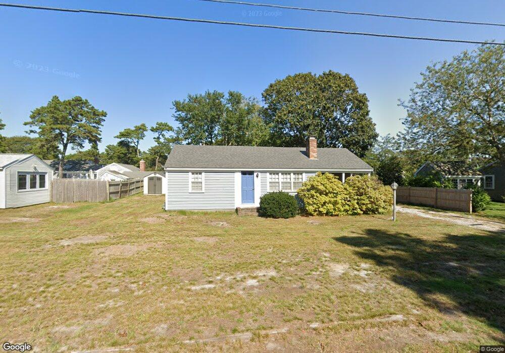
68 Santucket Rd West Dennis, MA 02670
West Dennis NeighborhoodEstimated Value: $533,000 - $749,000
3
Beds
1
Bath
840
Sq Ft
$791/Sq Ft
Est. Value
About This Home
This home is located at 68 Santucket Rd, West Dennis, MA 02670 and is currently estimated at $664,762, approximately $791 per square foot. 68 Santucket Rd is a home located in Barnstable County with nearby schools including Dennis-Yarmouth Regional High School.
Ownership History
Date
Name
Owned For
Owner Type
Purchase Details
Closed on
Jul 10, 2024
Sold by
68 Santucket Rt and Wildermuth
Bought by
Johnston Leicester S and Johnston Carol E
Current Estimated Value
Purchase Details
Closed on
Nov 9, 2015
Sold by
Joan C Johnston T C and Joan Johnston
Bought by
68 Santucket Rt and Wildermuth
Create a Home Valuation Report for This Property
The Home Valuation Report is an in-depth analysis detailing your home's value as well as a comparison with similar homes in the area
Home Values in the Area
Average Home Value in this Area
Purchase History
| Date | Buyer | Sale Price | Title Company |
|---|---|---|---|
| Johnston Leicester S | -- | None Available | |
| Johnston Leicester S | -- | None Available | |
| Johnston Leicester S | -- | None Available | |
| 68 Santucket Rt | -- | -- | |
| 68 Santucket Rt | -- | -- | |
| 68 Santucket Rt | -- | -- |
Source: Public Records
Mortgage History
| Date | Status | Borrower | Loan Amount |
|---|---|---|---|
| Previous Owner | 68 Santucket Rt | $50,000 |
Source: Public Records
Tax History Compared to Growth
Tax History
| Year | Tax Paid | Tax Assessment Tax Assessment Total Assessment is a certain percentage of the fair market value that is determined by local assessors to be the total taxable value of land and additions on the property. | Land | Improvement |
|---|---|---|---|---|
| 2025 | $2,726 | $629,600 | $386,600 | $243,000 |
| 2024 | $2,300 | $523,900 | $309,800 | $214,100 |
| 2023 | $2,224 | $476,300 | $281,700 | $194,600 |
| 2022 | $2,220 | $396,400 | $253,700 | $142,700 |
| 2021 | $5,158 | $365,500 | $248,800 | $116,700 |
| 2020 | $2,331 | $382,200 | $276,400 | $105,800 |
| 2019 | $2,285 | $370,400 | $271,000 | $99,400 |
| 2018 | $2,045 | $322,600 | $232,200 | $90,400 |
| 2017 | $1,966 | $319,700 | $232,200 | $87,500 |
| 2016 | $2,026 | $310,200 | $237,300 | $72,900 |
| 2015 | $1,985 | $310,200 | $237,300 | $72,900 |
| 2014 | $1,839 | $289,600 | $216,700 | $72,900 |
Source: Public Records
Map
Nearby Homes
- 2 Rita Mary Way
- 178 School St
- 14 Schoolhouse Ln
- 209 Main St Unit 3
- 209 Main St Unit 6
- 209 Main St Unit 1
- 209 Main St Unit 2
- 209 Main St Unit 4
- 209 Main St Unit 5
- 23 Doric Ave
- 401 Main St Unit 201
- 401 Main St Unit 101
- 467 Main St
- 308 Old Main St
- 428 Main St Unit 1-11
- 45 Seth Ln
- 181 Pleasant St
- 40 Kelley Rd
- 6 Baker Way
- 61 Trotters Ln
- 64 Santucket Rd
- 195 Loring Ave
- 72 Santucket Rd
- 187 Loring Ave
- 69 Santucket Rd
- 65 Santucket Rd
- 73 Santucket Rd
- 60 Santucket Rd
- 183 Loring Ave
- 77 Santucket Rd
- 61 Santucket Rd
- 72 Shore Rd
- 76 Shore Rd
- 68 Shore Rd
- 56 Santucket Rd
- 66 Kelleys Pond Rd
- 179 Loring Ave
- 65 Kelleys Pond Rd
- 65 Kelley's Pond Rd
- 57 Santucket Rd