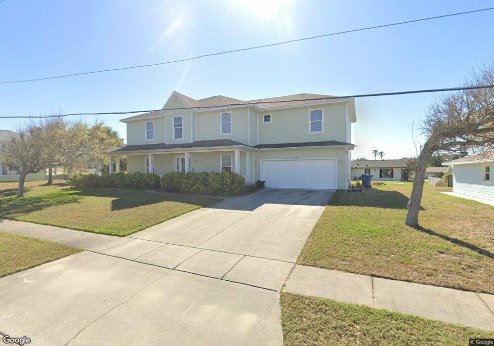
68 Seawinds Cir Ponce Inlet, FL 32127
Estimated Value: $778,000 - $1,090,000
4
Beds
2
Baths
3,110
Sq Ft
$289/Sq Ft
Est. Value
About This Home
This home is located at 68 Seawinds Cir, Ponce Inlet, FL 32127 and is currently estimated at $897,353, approximately $288 per square foot. 68 Seawinds Cir is a home located in Volusia County with nearby schools including R.J. Longstreet Elementary School, Silver Sands Middle School, and Spruce Creek High School.
Ownership History
Date
Name
Owned For
Owner Type
Purchase Details
Closed on
Oct 21, 1998
Sold by
Taynai Albert C and Taynai Barbara J
Bought by
Craig Dennis P and Craig Theresa A
Current Estimated Value
Home Financials for this Owner
Home Financials are based on the most recent Mortgage that was taken out on this home.
Original Mortgage
$117,000
Outstanding Balance
$25,064
Interest Rate
6.65%
Estimated Equity
$872,289
Purchase Details
Closed on
Mar 15, 1988
Bought by
Craig Dennis P and Craig Theresa A
Purchase Details
Closed on
Oct 15, 1979
Bought by
Craig Dennis P and Craig Theresa A
Create a Home Valuation Report for This Property
The Home Valuation Report is an in-depth analysis detailing your home's value as well as a comparison with similar homes in the area
Home Values in the Area
Average Home Value in this Area
Purchase History
| Date | Buyer | Sale Price | Title Company |
|---|---|---|---|
| Craig Dennis P | $130,000 | -- | |
| Craig Dennis P | $85,700 | -- | |
| Craig Dennis P | $67,500 | -- |
Source: Public Records
Mortgage History
| Date | Status | Borrower | Loan Amount |
|---|---|---|---|
| Open | Craig Dennis P | $117,000 |
Source: Public Records
Tax History Compared to Growth
Tax History
| Year | Tax Paid | Tax Assessment Tax Assessment Total Assessment is a certain percentage of the fair market value that is determined by local assessors to be the total taxable value of land and additions on the property. | Land | Improvement |
|---|---|---|---|---|
| 2025 | $6,972 | $442,537 | -- | -- |
| 2024 | $6,972 | $430,066 | -- | -- |
| 2023 | $6,972 | $417,540 | $0 | $0 |
| 2022 | $6,477 | $405,379 | $0 | $0 |
| 2021 | $6,833 | $393,572 | $0 | $0 |
| 2020 | $6,732 | $388,138 | $0 | $0 |
| 2019 | $6,553 | $379,412 | $0 | $0 |
| 2018 | $8,420 | $426,314 | $104,857 | $321,457 |
| 2017 | $8,972 | $449,070 | $105,222 | $343,848 |
| 2016 | $8,544 | $413,923 | $0 | $0 |
| 2015 | $8,012 | $369,985 | $0 | $0 |
| 2014 | $7,709 | $368,824 | $0 | $0 |
Source: Public Records
Map
Nearby Homes
- 4505 S Atlantic Ave Unit 305
- 4505 S Atlantic Ave Unit 6020
- 4505 S Atlantic Ave Unit 605
- 4505 S Atlantic Ave Unit 605
- 51 Sundunes Cir
- 4495 S Atlantic Ave Unit 4040
- 14 Marsh Ct
- 53 Daggett Cove Dr
- 4525 S Atlantic Ave Unit 1502
- 4555 S Atlantic Ave Unit 4411
- 4555 S Atlantic Ave Unit 4603
- 4555 S Atlantic Ave Unit 4609
- 4555 S Atlantic Ave Unit 4405
- 4555 S Atlantic Ave Unit 4202
- 4555 S Atlantic Ave Unit 4304
- 4575 S Atlantic Ave Unit 6502
- 4575 S Atlantic Ave Unit 6205
- 4575 S Atlantic Ave Unit 6101
- 4575 S Atlantic Ave Unit 6310
- 4545 S Atlantic Ave Unit 3206
- 70 Seawinds Cir
- 94 Maura Terrace
- 66 Seawinds Cir
- 92 Maura Terrace
- 69 Seawinds Cir
- 96 Maura Terrace
- 71 Seawinds Cir
- 72 Seawinds Cir
- 64 Seawinds Cir
- 98 Maura Terrace
- 61 Seawinds Cir
- 73 Seawinds Cir
- 55 Seawinds Cir
- 4496 S Atlantic Ave
- 53 Seawinds Cir
- 97 Maura Terrace
- 93 Maura Terrace
- 99 Maura Terrace
- 60 Seawinds Cir
- 4518 S Atlantic Ave