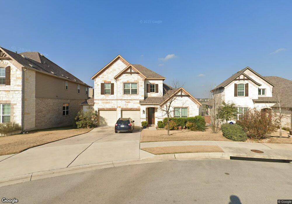
6806 Halesboro Dr Austin, TX 78736
West Oak Hill NeighborhoodEstimated Value: $600,000 - $777,000
3
Beds
3
Baths
2,297
Sq Ft
$292/Sq Ft
Est. Value
About This Home
This home is located at 6806 Halesboro Dr, Austin, TX 78736 and is currently estimated at $671,547, approximately $292 per square foot. 6806 Halesboro Dr is a home with nearby schools including Oak Hill Elementary School, Small Middle School, and James Bowie High School.
Ownership History
Date
Name
Owned For
Owner Type
Purchase Details
Closed on
Nov 21, 2017
Sold by
The Brohn Group Llc
Bought by
Taylor Zoe
Current Estimated Value
Home Financials for this Owner
Home Financials are based on the most recent Mortgage that was taken out on this home.
Original Mortgage
$2,296,441
Outstanding Balance
$1,234,777
Interest Rate
3.21%
Mortgage Type
New Conventional
Estimated Equity
-$563,230
Purchase Details
Closed on
May 25, 2017
Sold by
Covered Bridge Development Linc
Bought by
The Brohn Group Llc
Home Financials for this Owner
Home Financials are based on the most recent Mortgage that was taken out on this home.
Original Mortgage
$25,000,000
Interest Rate
4.08%
Mortgage Type
Commercial
Create a Home Valuation Report for This Property
The Home Valuation Report is an in-depth analysis detailing your home's value as well as a comparison with similar homes in the area
Home Values in the Area
Average Home Value in this Area
Purchase History
| Date | Buyer | Sale Price | Title Company |
|---|---|---|---|
| Taylor Zoe | -- | Platinum Title | |
| The Brohn Group Llc | -- | Independence Title Co |
Source: Public Records
Mortgage History
| Date | Status | Borrower | Loan Amount |
|---|---|---|---|
| Open | Taylor Zoe | $2,296,441 | |
| Previous Owner | The Brohn Group Llc | $25,000,000 |
Source: Public Records
Tax History Compared to Growth
Tax History
| Year | Tax Paid | Tax Assessment Tax Assessment Total Assessment is a certain percentage of the fair market value that is determined by local assessors to be the total taxable value of land and additions on the property. | Land | Improvement |
|---|---|---|---|---|
| 2025 | $10,756 | $703,613 | $151,153 | $552,460 |
| 2023 | $8,853 | $592,934 | $0 | $0 |
| 2022 | $10,645 | $539,031 | $0 | $0 |
| 2021 | $10,666 | $490,028 | $100,000 | $390,028 |
| 2020 | $10,074 | $469,670 | $100,000 | $369,670 |
| 2018 | $10,645 | $480,790 | $100,000 | $380,790 |
| 2016 | $669 | $15,000 | $15,000 | $0 |
Source: Public Records
Map
Nearby Homes
- 6718 Silvermine Dr Unit 903
- 6718 Silvermine Dr Unit 804
- 8818 Moccasin Path
- 6701 Covered Bridge Dr
- 6701 Covered Bridge Dr Unit 51
- 6701 Covered Bridge Dr Unit 40
- 8005 Red Willow Dr
- 7008 Chinook Dr
- 7010 Harvest Trail Dr
- 7324 Covered Bridge Dr
- 8536 Red Willow Dr
- Plan 2070 at Creekside at Estancia
- Plan 2245 at Creekside at Estancia
- Plan 1888 at Scenic Pass
- Plan 2881 at Scenic Pass
- Plan 1675 at Scenic Pass
- Plan 2586 at Creekside at Estancia
- Plan 1908 Modeled at Creekside at Estancia
- Plan 2469 at Scenic Pass
- Plan 2527 Modeled at Creekside at Estancia
- 6810 Halesboro Dr
- 6800 Halesboro Dr
- 6814 Halesboro Dr
- 6811 Halesboro Dr
- 6801 Halesboro Dr
- 6819 Halesboro Dr
- 6810 Smokey Hill Rd
- 8604 Roxton Cove
- 8600 Roxton Cove
- 6815 Halesboro Dr
- 6814 Smokey Hill Rd
- 8608 Roxton Cove
- 6817 Halesboro Dr
- 6712 Raccoon Run
- 6808 Smokey Hill Rd
- 0 Roxton Cove
- 6823 Halesboro Dr
- 6901 Halesboro Dr
- 8612 Roxton Cove
- 6900 Smokey Hill Rd