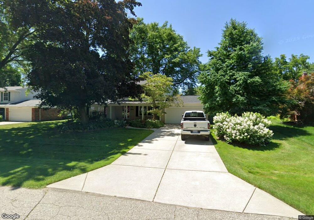
6806 Lee Crest Dr West Bloomfield, MI 48322
Estimated Value: $334,000 - $412,000
4
Beds
2
Baths
1,705
Sq Ft
$215/Sq Ft
Est. Value
About This Home
This home is located at 6806 Lee Crest Dr, West Bloomfield, MI 48322 and is currently estimated at $367,377, approximately $215 per square foot. 6806 Lee Crest Dr is a home located in Oakland County with nearby schools including Sheiko Elementary School, West Bloomfield Middle School, and Maria Montessori Center.
Ownership History
Date
Name
Owned For
Owner Type
Purchase Details
Closed on
Jun 1, 2014
Sold by
Stern Eubanks Gary L and Stern Eubanks Gayle
Bought by
Stern Eubanks Gary L and Stern Eubanks Gayle
Current Estimated Value
Purchase Details
Closed on
Jun 1, 2012
Sold by
Stern Eubanks Gary L and Stern Eubanks Gayle
Bought by
Eubanks Gary L and Eubanks Gayle S
Home Financials for this Owner
Home Financials are based on the most recent Mortgage that was taken out on this home.
Original Mortgage
$159,300
Interest Rate
3.87%
Mortgage Type
New Conventional
Create a Home Valuation Report for This Property
The Home Valuation Report is an in-depth analysis detailing your home's value as well as a comparison with similar homes in the area
Home Values in the Area
Average Home Value in this Area
Purchase History
| Date | Buyer | Sale Price | Title Company |
|---|---|---|---|
| Stern Eubanks Gary L | -- | None Available | |
| Eubanks Gary L | -- | None Available |
Source: Public Records
Mortgage History
| Date | Status | Borrower | Loan Amount |
|---|---|---|---|
| Closed | Eubanks Gary L | $159,300 |
Source: Public Records
Tax History Compared to Growth
Tax History
| Year | Tax Paid | Tax Assessment Tax Assessment Total Assessment is a certain percentage of the fair market value that is determined by local assessors to be the total taxable value of land and additions on the property. | Land | Improvement |
|---|---|---|---|---|
| 2024 | $2,135 | $151,230 | $0 | $0 |
| 2022 | $2,044 | $127,130 | $35,190 | $91,940 |
| 2021 | $3,107 | $123,920 | $0 | $0 |
| 2020 | $1,992 | $121,270 | $35,190 | $86,080 |
| 2018 | $2,979 | $101,950 | $27,070 | $74,880 |
| 2015 | -- | $81,190 | $0 | $0 |
| 2014 | -- | $76,090 | $0 | $0 |
| 2011 | -- | $80,470 | $0 | $0 |
Source: Public Records
Map
Nearby Homes
- 6843 Leslee Crest Dr
- 6769 Heather Heath
- 6624 Mellow Wood Ln
- 7027 Beverly Crest Dr
- 7023 Wild Ridge Ln
- 4161 Breckenridge Dr
- 6651 Hearthside Ct Unit 1
- 6621 Bellows Ct Unit 62
- 6322 Pepper Hill St Unit 62
- 6222 Pepper Hill St
- 6151 Orchard Lake Rd Unit 103
- 6145 Orchard Lake Rd Unit 204
- 6109 Orchard Lake Rd Unit 101
- 6564 Alderley Way
- 7335 Coach Ln
- 7421 Heather Heath
- 7251 N Briarcliff Knoll Dr
- 4392 Gateway Cir Unit 59
- 6545 Post Oak Dr
- 7477 Heather Heath
- 6792 Lee Crest Dr
- 6822 Lee Crest Dr
- 6787 Beverly Crest Dr
- 6807 Beverly Crest Dr
- 6780 Lee Crest Dr
- 6838 Lee Crest Dr
- 6765 Beverly Crest Dr
- 6801 Lee Crest Dr
- 6817 Lee Crest Dr
- 6789 Lee Crest Dr
- 6743 Beverly Crest Dr
- 6833 Lee Crest Dr
- 6768 Lee Crest Dr
- 6854 Lee Crest Dr
- 6851 Beverly Crest Dr
- 6777 Lee Crest Dr
- 6849 Lee Crest Dr
- 6721 Beverly Crest Dr Unit Bldg-Unit
- 6721 Beverly Crest Dr
- 6788 Beverly Crest Dr