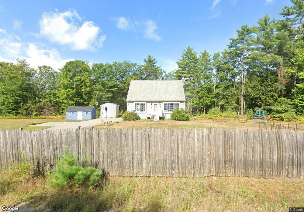
681 Elm St Limerick, ME 04048
Estimated Value: $346,000 - $416,000
2
Beds
1
Bath
1,768
Sq Ft
$220/Sq Ft
Est. Value
About This Home
This home is located at 681 Elm St, Limerick, ME 04048 and is currently estimated at $388,503, approximately $219 per square foot. 681 Elm St is a home located in York County with nearby schools including Massabesic High School.
Ownership History
Date
Name
Owned For
Owner Type
Purchase Details
Closed on
Apr 15, 2011
Sold by
Ladd Joanne M and Ladd Brent L
Bought by
Nantel Robert J
Current Estimated Value
Home Financials for this Owner
Home Financials are based on the most recent Mortgage that was taken out on this home.
Original Mortgage
$119,700
Outstanding Balance
$82,334
Interest Rate
4.89%
Mortgage Type
Purchase Money Mortgage
Estimated Equity
$306,169
Purchase Details
Closed on
Sep 5, 2006
Sold by
Marcotte Raymond
Bought by
Ladd Joanne M and Ladd Brent L
Home Financials for this Owner
Home Financials are based on the most recent Mortgage that was taken out on this home.
Original Mortgage
$190,413
Interest Rate
6.83%
Mortgage Type
Purchase Money Mortgage
Create a Home Valuation Report for This Property
The Home Valuation Report is an in-depth analysis detailing your home's value as well as a comparison with similar homes in the area
Home Values in the Area
Average Home Value in this Area
Purchase History
| Date | Buyer | Sale Price | Title Company |
|---|---|---|---|
| Nantel Robert J | -- | -- | |
| Ladd Joanne M | -- | -- |
Source: Public Records
Mortgage History
| Date | Status | Borrower | Loan Amount |
|---|---|---|---|
| Open | Nantel Robert J | $119,700 | |
| Previous Owner | Ladd Joanne M | $190,413 |
Source: Public Records
Tax History
| Year | Tax Paid | Tax Assessment Tax Assessment Total Assessment is a certain percentage of the fair market value that is determined by local assessors to be the total taxable value of land and additions on the property. | Land | Improvement |
|---|---|---|---|---|
| 2025 | $3,188 | $335,615 | $85,123 | $250,492 |
| 2024 | $3,188 | $335,615 | $85,123 | $250,492 |
| 2023 | $2,919 | $192,060 | $40,840 | $151,220 |
| 2022 | $2,727 | $192,060 | $40,840 | $151,220 |
| 2021 | $2,551 | $153,648 | $32,672 | $120,976 |
| 2020 | $2,520 | $153,648 | $32,672 | $120,976 |
| 2019 | $2,420 | $153,648 | $32,672 | $120,976 |
| 2018 | $2,481 | $153,648 | $32,672 | $120,976 |
| 2017 | $2,420 | $153,648 | $32,672 | $120,976 |
| 2016 | $2,312 | $153,648 | $32,672 | $120,976 |
| 2015 | $2,243 | $153,648 | $32,672 | $120,976 |
| 2014 | $2,174 | $153,648 | $32,672 | $120,976 |
Source: Public Records
Map
Nearby Homes
- 451 Range E Rd
- 515 Range East Rd
- 545 Foss Rd
- 0 Stone Hill Rd
- 0 Mowry 0 Row Mowry Ln
- 590 Newfield Rd
- 220 Bond Spring Rd
- 25 Onamor Dr
- 5 Wescott St
- 0 Quarry Rd
- TBD Sokokis Trail & Beaver Brook Rd
- TBB Sokokis Trail & Beaver Brook Rd
- 24 Emery Corner Rd
- 4 Deer Crossing Rd
- 50 Island Rd
- Lot TBD Maplewood Rd
- LOT# 8 Business Park Rd
- Lot# 11 Business Park Rd
- 0 Island Rd Unit 1643509
- M13L30 Clarks Bridge Rd
Your Personal Tour Guide
Ask me questions while you tour the home.