Estimated Value: $394,779 - $561,000
3
Beds
3
Baths
1,771
Sq Ft
$275/Sq Ft
Est. Value
About This Home
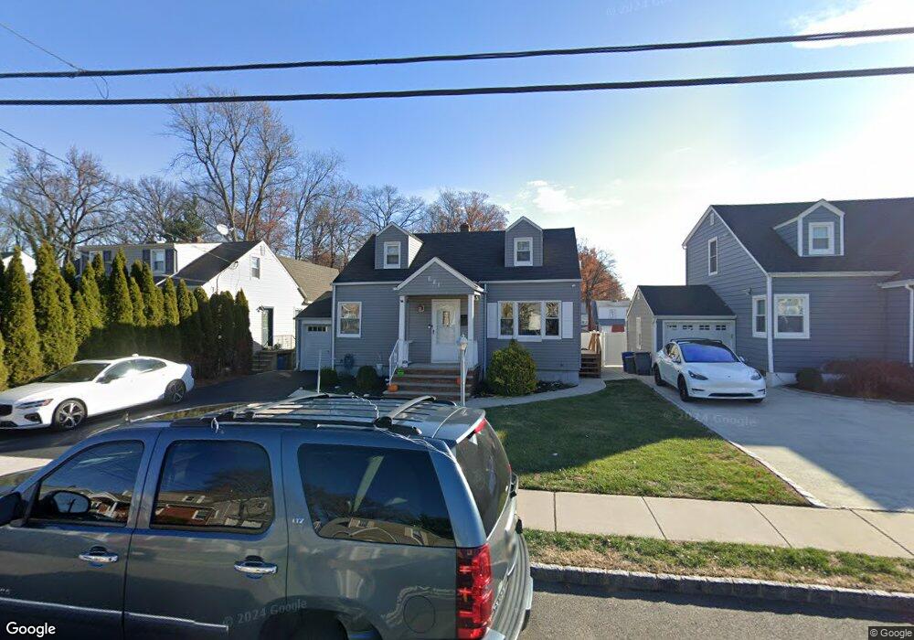
This home is located at 681 Palisade Rd, Union, NJ 07083 and is currently estimated at $487,695, approximately $275 per square foot. 681 Palisade Rd is a home located in Union County with nearby schools including Washington Elementary School, Union High School, and Jewish Educational Center Lower School.
Ownership History
Date
Name
Owned For
Owner Type
Purchase Details
Closed on
Aug 21, 2023
Sold by
Robinson Nateasha and Robinson Jermaine
Bought by
Montes Kishanda Larrette
Current Estimated Value
Home Financials for this Owner
Home Financials are based on the most recent Mortgage that was taken out on this home.
Original Mortgage
$337,250
Outstanding Balance
$329,777
Interest Rate
6.96%
Mortgage Type
New Conventional
Estimated Equity
$157,918
Purchase Details
Closed on
Apr 25, 2014
Sold by
Carlin Donna A
Bought by
Robinson Nateasha
Home Financials for this Owner
Home Financials are based on the most recent Mortgage that was taken out on this home.
Original Mortgage
$210,622
Interest Rate
4.25%
Mortgage Type
FHA
Purchase Details
Closed on
Feb 2, 2009
Sold by
Carlin Anthony and Carlin Donna A
Bought by
Carlin Donna A
Create a Home Valuation Report for This Property
The Home Valuation Report is an in-depth analysis detailing your home's value as well as a comparison with similar homes in the area
Home Values in the Area
Average Home Value in this Area
Purchase History
| Date | Buyer | Sale Price | Title Company |
|---|---|---|---|
| Montes Kishanda Larrette | $355,000 | Ats Title | |
| Montes Kishanda Larrette | $355,000 | Ats Title | |
| Robinson Nateasha | $230,000 | None Available | |
| Carlin Donna A | $60,544 | Stewart Title Guaranty Co |
Source: Public Records
Mortgage History
| Date | Status | Borrower | Loan Amount |
|---|---|---|---|
| Open | Montes Kishanda Larrette | $337,250 | |
| Closed | Montes Kishanda Larrette | $337,250 | |
| Previous Owner | Robinson Nateasha | $210,622 |
Source: Public Records
Tax History Compared to Growth
Tax History
| Year | Tax Paid | Tax Assessment Tax Assessment Total Assessment is a certain percentage of the fair market value that is determined by local assessors to be the total taxable value of land and additions on the property. | Land | Improvement |
|---|---|---|---|---|
| 2025 | $8,583 | $38,400 | $20,600 | $17,800 |
| 2024 | $8,321 | $38,400 | $20,600 | $17,800 |
Source: Public Records
Map
Nearby Homes
- 925 Woodland Ave
- 1031 Lowden Ave
- 757 Floral Ave Unit 59
- 842 Travers St
- 437 Durling Rd
- 1084 Woodland Ave
- 790 Green Ln Unit A1
- 836 Livingston Rd Unit 838
- 161 Morristown Rd Unit 63
- 138 Monmouth Rd Unit 40
- 137-139 Monmouth Rd
- 837 Park Ave Unit 839
- 263 Stiles St
- 571 Morris Ave Unit 573
- 630 Park Ave Unit 32
- 875 Salem Rd
- 969 Arnet Ave
- 241 Crystal Terrace
- 45 Summit Rd Unit 47
- 275 Clermont Terrace
- 685 Palisade Rd
- 677 Palisade Rd
- 673 Palisade Rd
- 689 Palisade Rd
- 452 Verona Ave Unit 454
- 448 Verona Ave Unit 50
- 667 Palisade Rd
- 693 Palisade Rd
- 444 Verona Ave Unit 446
- 440 Verona Ave Unit 442
- 680 Palisade Rd
- 684 Palisade Rd
- 697 Palisade Rd
- 676 Palisade Rd
- 661 Palisade Rd
- 436 Verona Ave Unit 38
- 688 Palisade Rd
- 670 Palisade Rd
- 692 Palisade Rd
- 701 Palisade Rd