NOT LISTED FOR SALE

6812 Queens High Rd Unit 409-25-038 Show Low, AZ 85901

Estimated Value: $537,000 - $600,993

4.98 Acres
$115,729 Price per Acre
216,929 Sq Ft Lot

Last Sold February 22, 2018

Last sale price $68,000

Est. 748% increase in value since last sale

Current estimated payment $3,431/month

44 Days on Market

Highlights

  • Mountain View
  • Show Low High School Rated A-
  • No HOA

About This Lot

As of February 2018

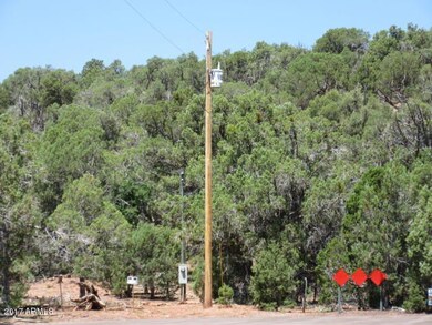
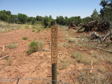
GORGEOUS 4.98 ACRE PARCEL BACKING NATIONAL FOREST! This lovely lot offers plenty of level ground for the perfect home site. The topography offers level, rolling and sloping grounds as well for maximum seclusion. Long distance views of Linden are also available. Located close to town for easy convenience to shopping, hospital and dining. Fools Hollow Lake is minutes away. Paved street for easy access and power at the property line. Don't let this one get away! The road through the property was cut by firefighters as a fire break back during the Rodeo Chediski fire it is NOT an easement.

Last Agent to Sell the Property

Amy Johnson

Advantage Realty Professionals License #SA629955000 Listed on: 12/11/2017

Last Buyer's Agent

Amy Johnson

Advantage Realty Professionals License #SA629955000 Listed on: 12/11/2017

Property Details

Property Type

  • Land

Est. Annual Taxes

  • $659

Year Built

  • 2022

Lot Details

  • 4.98

Additional Features

  • 4.98 Acre Lot
  • Mountain Views

Community Details

  • No Home Owners Association
  • Fool Hollow Rh Subdivision

Listing and Financial Details

  • Tax Lot 409-25-038
  • Assessor Parcel Number 409-25-038

Property Details

Property Type

Land

Est. Annual Taxes

$659

Year Built

2022

Lot Details

0

Listing Details

  • Property Type: Land
  • Development Status: Raw Land
  • Zoning: .
  • Tax Year: 2016
  • Lot Size Acres: 4.98
  • Subdivision Name: Fool Hollow RH
  • Special Features: None
  • Property Sub Type: LotsLands
  • Year Built (Public Record): 2022

Interior Features

  • Possible Use: Single Family, Mobile/Mgf Hme/RV's, Ranch

Exterior Features

  • Lot Features: Mountain View(s)
  • Disclosures: None

Utilities

  • Electric: APS
  • Water Source: None

Condo/Co-op/Association

  • Association: No

Schools

  • Elementary School: Other
  • High School: Other
  • Middle Or Junior School: Other

Lot Info

  • Lot Size: .
  • Lot Size Sq Ft: 216929.0
  • Additional Parcels: No
  • Parcel #: 409-25-038
  • ResoLotSizeUnits: Acres

Tax Info

  • Tax Annual Amount: 659.0
  • Tax Book Number: 409.00
  • Tax Lot: 409-25-038
  • Tax Map Number: 25.00

Ownership History

Date Name Owned For Owner Type

Purchase Details

Closed on
Sep 29, 2020
Sold by
Davis Darrin and Davis Nicole
Bought by
Aberle Timothy L and Aberle Cynthia A
Total Days on Market
44
Current Estimated Value
$576,331

Purchase Details

Listed on
Dec 11, 2017
Closed on
Feb 14, 2018
Sold by
Parberry Larry C
Bought by
Davis Darrin and Davis Nicole
Seller's Agent
Amy Johnson
Advantage Realty Professionals
Buyer's Agent
Amy Johnson
Advantage Realty Professionals
List Price
$74,777
Sold Price
$68,000
Premium/Discount to List
-$6,777
-9.06%

Home Financials for this Owner

Home Financials are based on the most recent Mortgage that was taken out on this home.
Avg. Annual Appreciation
33.96%
Source: Public Records

Similar Properties in Show Low, AZ

  • SEC E Deuce of Clubs, Show Low, AZ 85901

    $450,000

    • Land
    • 3.81 Acres
    • $118,110 per Acre
    • SEC E Deuce of Clubs
    • Show Low, AZ

    This land is located on the corner of the 2 primary thourghfares through Show Low, State Routes 60 & 260 and located East of Starbucks and Discount Tire. Sitting on 3.81 acres in the heart of Show Low. Call today for more information!

    Barry Nicks Realty Executives AZ Territory - Show Low

    Section Image
  • 3800 N Industrial Loop, Show Low, AZ 85901

    $675,000

    • Land
    • 3.87 Acres
    • $174,419 per Acre
    • 3800 N Industrial Loop
    • Show Low, AZ

    Industrial parcel in the Airport Industrial Park. There are a total of 11.38 acres available. Parcel 210-59-007 3.72 acres, Parcel 210-73-004 .93 acres, Parcel 210-73-001 1.86 acres, Parcel 210-59-004 3.87 acres, Parcel 210-59-003A 1 acre. Available all together or induvidually at $4/sq ftA TOTAL of 11.38 acres available MLS #250578 Parcel 210-59-007 3.72 acresMLS #250577 Parcel 210-73-004

    Barry Nicks Realty Executives AZ Territory - Show Low

    Section Image

Range of Values:

Collateral Analytics

Collateral Analytics Collateral Analytics AVMs (Automated Valuation Model) employ a number of statistical approaches combined with neighborhood-specific comparable selection guarantees the most up-to-date and precise valuations.

Not Available

Collateral Analytics does not have data for the current month. Please view the chart for historical values.

ICE

ICE Mortgage Technology ICE Mortgage Technology’s AVM (Automated Valuation Model) is a state-of-the-art online residential property valuation tool that provides a quick and accurate estimate of the value of almost any home in the U.S.

Not Available

ICE Mortgage Technology does not have data for the current month. Please view the chart for historical values.

First American

First American First American Data & Analytics’ next-generation AVM combines unrivaled data assets with a blended ensemble of valuation models to produce highly accurate, reliable valuations you can trust.

Not Available

First American does not have data for the current month. Please view the chart for historical values.

Quantarium

Quantarium Quantarium’s valuation service, repeatedly proven the industry’s most accurate and comprehensive, is supercharged with a self-learning and auto-tuning AI engine that continually becomes smarter and more accurate as it processes daily inputs from the industry’s leading RE data lake.

Not Available

Quantarium does not have data for the current month. Please view the chart for historical values.

Average Value
Not Available
List Price
Sold Price
Create a Home Valuation Report for This Property
The Home Valuation Report is an in-depth analysis detailing your home's value as well as a comparison with similar homes in the area

Home Values in the Area

Source: Public Records

Average Home Value in this Area


Source: Public Records

Purchase History

Date Buyer Sale Price Title Company
Aberle Timothy L $80,000 Pioneer Title Agency Inc
Davis Darrin $67,500 Pioneer Title Agency Inc
Source: Public Records

Property History

Date Event Price Change Sq Ft Price
02/22/2018 02/22/18 Sold $68,000 -9.1% --
01/24/2018 01/24/18 Pending -- -- --
12/11/2017 12/11/17 For Sale $74,777 -- --
Source: Arizona Regional Multiple Listing Service (ARMLS)

Tax History Compared to Growth

Source: Public Records

Tax History

Year Tax Paid Tax Assessment Tax Assessment Total Assessment is a certain percentage of the fair market value that is determined by local assessors to be the total taxable value of land and additions on the property. Land Improvement
2026 $2,495 -- -- --
2025 $760 $47,491 $11,109 $36,382
2024 $719 $50,655 $14,115 $36,540
2023 $760 $9,678 $9,678 $0
2022 $719 $0 $0 $0
2021 $720 $0 $0 $0
2020 $677 $0 $0 $0
2019 $675 $0 $0 $0
2018 $644 $0 $0 $0
2017 $606 $0 $0 $0
2016 $628 $0 $0 $0
2015 $660 $5,773 $5,773 $0
Source: Public Records

Agents Affiliated with this Home

  • Section Image
See All Agents

Map

Source: Arizona Regional Multiple Listing Service (ARMLS)

MLS Number: 5697528

Arizona Regional Multiple Listing Service (ARMLS)

APN: 409-25-038