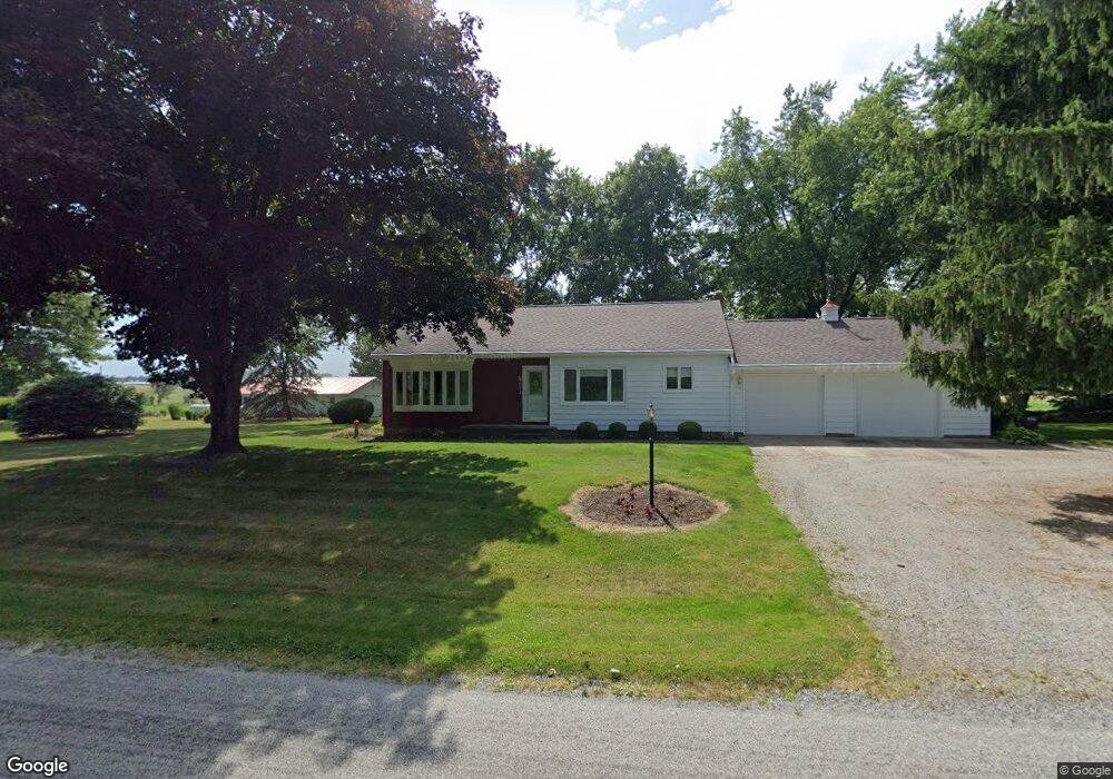
6814 Bates Rd West Salem, OH 44287
Estimated Value: $191,000 - $267,000
3
Beds
1
Bath
1,351
Sq Ft
$176/Sq Ft
Est. Value
About This Home
This home is located at 6814 Bates Rd, West Salem, OH 44287 and is currently estimated at $238,451, approximately $176 per square foot. 6814 Bates Rd is a home located in Wayne County with nearby schools including Northwestern Elementary School and Northwestern Middle School.
Ownership History
Date
Name
Owned For
Owner Type
Purchase Details
Closed on
Oct 13, 2005
Sold by
Estate Of Margaret L Kaufman
Bought by
Kaufman Daniel E and Johnson Rickie W
Current Estimated Value
Purchase Details
Closed on
Oct 10, 2005
Sold by
Boreman Linda Lou and Boreman John E
Bought by
Kaufman Daniel E
Purchase Details
Closed on
Sep 30, 2005
Sold by
Wharton John Hudley and Wharton Jodie M
Bought by
Kaufman Daniel E
Purchase Details
Closed on
Sep 28, 2005
Sold by
Johnson Randy Lynn and Johnson Marilyn
Bought by
Kaufman Daniel E
Purchase Details
Closed on
Sep 27, 2005
Sold by
Johnson Rickie W and Johnson Karen
Bought by
Kaufman Daniel E
Create a Home Valuation Report for This Property
The Home Valuation Report is an in-depth analysis detailing your home's value as well as a comparison with similar homes in the area
Home Values in the Area
Average Home Value in this Area
Purchase History
| Date | Buyer | Sale Price | Title Company |
|---|---|---|---|
| Kaufman Daniel E | -- | -- | |
| Kaufman Daniel E | $38,500 | -- | |
| Kaufman Daniel E | $38,500 | -- | |
| Kaufman Daniel E | $38,500 | -- | |
| Kaufman Daniel E | $38,500 | -- |
Source: Public Records
Tax History Compared to Growth
Tax History
| Year | Tax Paid | Tax Assessment Tax Assessment Total Assessment is a certain percentage of the fair market value that is determined by local assessors to be the total taxable value of land and additions on the property. | Land | Improvement |
|---|---|---|---|---|
| 2024 | $1,983 | $66,640 | $17,630 | $49,010 |
| 2023 | $1,983 | $66,640 | $17,630 | $49,010 |
| 2022 | $1,483 | $47,260 | $12,500 | $34,760 |
| 2021 | $1,486 | $47,260 | $12,500 | $34,760 |
| 2020 | $1,503 | $47,260 | $12,500 | $34,760 |
| 2019 | $1,002 | $32,760 | $11,050 | $21,710 |
| 2018 | $980 | $32,760 | $11,050 | $21,710 |
| 2017 | $925 | $32,760 | $11,050 | $21,710 |
| 2016 | $893 | $31,500 | $10,630 | $20,870 |
| 2015 | $879 | $31,500 | $10,630 | $20,870 |
| 2014 | $1,228 | $31,500 | $10,630 | $20,870 |
| 2013 | $1,292 | $32,160 | $10,510 | $21,650 |
Source: Public Records
Map
Nearby Homes
- 10212 Lattasburg Rd
- 7789 Cedar Valley Rd
- 9657 W Smithville Western Rd
- V/L #10 Rice Hill Rd
- V/L #8 Rice Hill Rd
- V/L #7 Rice Hill Rd
- V/L #5 Rice Hill Rd
- V/L #11 Rice Hill Rd
- V/L #13 Rice Hill Rd
- V/L #2 Rice Hill Rd
- V/L #9 Rice Hill Rd
- V/L #6 Rice Hill Rd
- V/L #4 Rice Hill Rd
- V/L #3 Rice Hill Rd
- V/L #1 Rice Hill Rd
- 104 N Maple St
- 8743 Ashland Rd
- 5167 Overton Rd
- 3125 Henderson Rd
- 11827 Stratton Rd