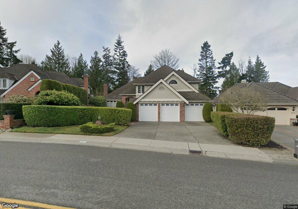
6819 St Andrews Dr Mukilteo, WA 98275
Harbour Pointe NeighborhoodEstimated Value: $1,379,000 - $1,613,000
4
Beds
3
Baths
3,028
Sq Ft
$484/Sq Ft
Est. Value
About This Home
This home is located at 6819 St Andrews Dr, Mukilteo, WA 98275 and is currently estimated at $1,464,209, approximately $483 per square foot. 6819 St Andrews Dr is a home located in Snohomish County with nearby schools including Endeavour Elementary School, Harbour Pointe Middle School, and Kamiak High School.
Ownership History
Date
Name
Owned For
Owner Type
Purchase Details
Closed on
Jan 3, 2014
Sold by
Ngo Tung Thanh and Ngo Tung T
Bought by
Ngo Tung Thanh and La Hang Thi Thu
Current Estimated Value
Purchase Details
Closed on
Jun 22, 2009
Sold by
Lahang T
Bought by
Ngo Tung T
Purchase Details
Closed on
Sep 29, 1994
Sold by
John F Buchan Construction Inc
Bought by
Patton Gary J and Patton Suzanne B
Home Financials for this Owner
Home Financials are based on the most recent Mortgage that was taken out on this home.
Original Mortgage
$324,800
Interest Rate
8.58%
Create a Home Valuation Report for This Property
The Home Valuation Report is an in-depth analysis detailing your home's value as well as a comparison with similar homes in the area
Home Values in the Area
Average Home Value in this Area
Purchase History
| Date | Buyer | Sale Price | Title Company |
|---|---|---|---|
| Ngo Tung Thanh | -- | None Available | |
| Ngo Tung T | -- | First American Title Ins Co | |
| Ngo Tung T | $644,300 | First American Title Ins Co | |
| Patton Gary J | $406,000 | -- |
Source: Public Records
Mortgage History
| Date | Status | Borrower | Loan Amount |
|---|---|---|---|
| Previous Owner | Patton Gary J | $324,800 |
Source: Public Records
Tax History Compared to Growth
Tax History
| Year | Tax Paid | Tax Assessment Tax Assessment Total Assessment is a certain percentage of the fair market value that is determined by local assessors to be the total taxable value of land and additions on the property. | Land | Improvement |
|---|---|---|---|---|
| 2025 | $8,147 | $1,134,100 | $605,200 | $528,900 |
| 2024 | $8,147 | $1,123,800 | $620,100 | $503,700 |
| 2023 | $9,359 | $1,333,000 | $507,500 | $825,500 |
| 2022 | $8,311 | $1,015,900 | $315,200 | $700,700 |
| 2020 | $8,002 | $984,300 | $298,300 | $686,000 |
| 2019 | $7,270 | $914,800 | $270,300 | $644,500 |
| 2018 | $7,709 | $841,400 | $242,400 | $599,000 |
| 2017 | $7,439 | $844,100 | $281,900 | $562,200 |
| 2016 | $6,792 | $766,600 | $221,700 | $544,900 |
| 2015 | $7,431 | $754,100 | $249,300 | $504,800 |
| 2013 | $6,000 | $569,000 | $207,900 | $361,100 |
Source: Public Records
Map
Nearby Homes
- 12011 Marine View Dr
- 12104 Possession Ln
- 12117 Clearview Dr
- 11017 Villa Rosa Ln Unit 11017
- 11902 Possession Ln
- 5824 111th Place SW
- 106 Xx MacArthur Ln
- 11521 Pine Ct Unit 4
- 5615 114th St SW
- 5500 Harbour Pointe Blvd Unit B202
- 6523 128th Place SW
- 6509 128th Place SW
- 5400 Harbour Pointe Blvd Unit F 201
- 5300 Harbour Pointe Blvd Unit 307A
- 5300 Harbour Pointe Blvd Unit 311H
- 12807 60th Ave W
- 12303 Harbour Pointe Blvd Unit W101
- 11702 Wilmington Way
- 12058 Concord Way
- 9716 58th Place W
- 6815 St Andrews Dr
- 6823 St Andrews Dr
- 6811 St Andrews Dr
- 6827 St Andrews Dr
- 6806 St Andrews Dr
- 6820 St Andrews Dr
- 11416 St Andrews Place
- 6831 St Andrews Dr
- 6802 St Andrews Dr
- 6824 St Andrews Dr
- 6633 St Andrews Place
- 11410 St Andrews Place
- 6728 St Andrews Dr
- 11403 St Andrews Place
- 6835 St Andrews Dr
- 6828 St Andrews Dr
- 6724 St Andrews Dr
- 11401 St Andrews Place
- 11408 St Andrews Place
- 11408 Andrews Place