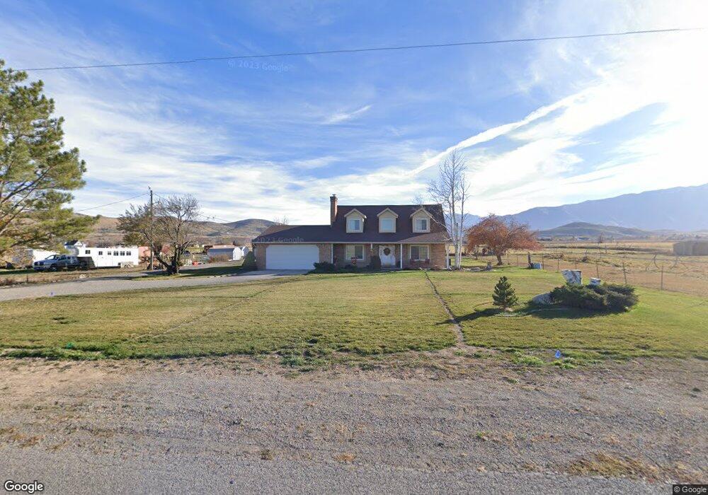
682 N Main St Genola, UT 84655
Estimated Value: $743,000 - $1,210,000
3
Beds
3
Baths
2,722
Sq Ft
$374/Sq Ft
Est. Value
About This Home
This home is located at 682 N Main St, Genola, UT 84655 and is currently estimated at $1,017,084, approximately $373 per square foot. 682 N Main St is a home located in Utah County with nearby schools including Goshen Elementary school, Payson Junior High School, and Payson High School.
Ownership History
Date
Name
Owned For
Owner Type
Purchase Details
Closed on
Aug 24, 2016
Sold by
Dustin Cox
Bought by
White Ronald and White Naomi
Current Estimated Value
Home Financials for this Owner
Home Financials are based on the most recent Mortgage that was taken out on this home.
Original Mortgage
$360,000
Outstanding Balance
$286,774
Interest Rate
3.43%
Estimated Equity
$730,310
Purchase Details
Closed on
Aug 23, 2002
Sold by
Jensen Michael B and Jensen Ganene C
Bought by
White Ronald M and White Naomi N
Home Financials for this Owner
Home Financials are based on the most recent Mortgage that was taken out on this home.
Original Mortgage
$217,100
Interest Rate
6.52%
Create a Home Valuation Report for This Property
The Home Valuation Report is an in-depth analysis detailing your home's value as well as a comparison with similar homes in the area
Home Values in the Area
Average Home Value in this Area
Purchase History
| Date | Buyer | Sale Price | Title Company |
|---|---|---|---|
| White Ronald | -- | -- | |
| White Ronald M | -- | Wasatch Land & Title |
Source: Public Records
Mortgage History
| Date | Status | Borrower | Loan Amount |
|---|---|---|---|
| Open | White Ronald | $360,000 | |
| Closed | White Ronald | -- | |
| Previous Owner | White Ronald M | $217,100 |
Source: Public Records
Tax History Compared to Growth
Tax History
| Year | Tax Paid | Tax Assessment Tax Assessment Total Assessment is a certain percentage of the fair market value that is determined by local assessors to be the total taxable value of land and additions on the property. | Land | Improvement |
|---|---|---|---|---|
| 2025 | $1,947 | $234,459 | $463,800 | $328,600 |
| 2024 | $1,953 | $201,436 | $0 | $0 |
| 2023 | $1,953 | $202,372 | $0 | $0 |
| 2022 | $1,792 | $709,500 | $470,800 | $238,700 |
| 2021 | $1,588 | $549,000 | $353,500 | $195,500 |
| 2020 | $1,350 | $497,200 | $307,400 | $189,800 |
| 2019 | $1,165 | $448,000 | $282,500 | $165,500 |
| 2018 | $1,077 | $411,400 | $267,500 | $143,900 |
| 2017 | $1,102 | $94,130 | $0 | $0 |
| 2016 | $1,096 | $94,046 | $0 | $0 |
| 2015 | $1,107 | $94,026 | $0 | $0 |
| 2014 | $984 | $83,886 | $0 | $0 |
Source: Public Records
Map
Nearby Homes
- 956 N Main St
- 1220 N Hillside Dr
- 1010 S Anna Ekins Memorial Ln
- 975 E 715 S
- 692 Frost St Unit 84
- 688 Frost St Unit 85
- 686 W Frost St Unit 86
- 11508 S 5825 W
- 346 Red Rock Dr
- 358 W 910 N
- 5746 W 11300 S
- 931 N 215 W
- 251 N Polly Ln
- 251 N Polly Ln Unit 4
- McIntosh Plan at The Orchards
- Honey Plan at The Orchards
- Cranford Plan at The Orchards
- Monroe Plan at The Orchards
- Benson Plan at The Orchards
- Gala Plan at The Orchards