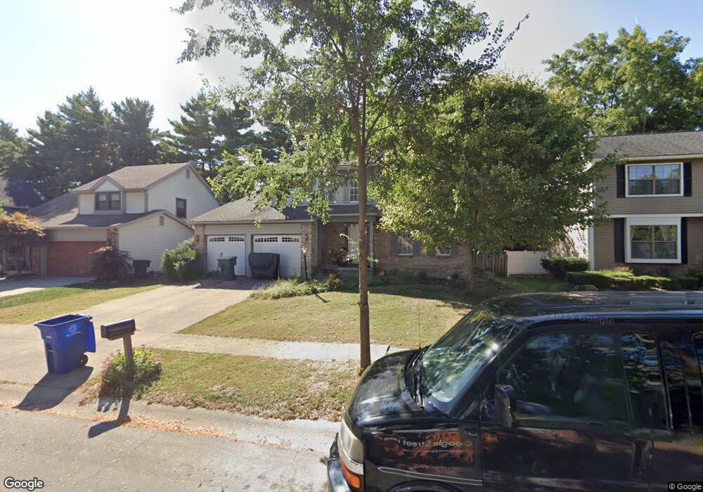
6839 Pine Bark Ln Columbus, OH 43235
Brookside Colony NeighborhoodEstimated Value: $398,528 - $453,000
4
Beds
3
Baths
2,099
Sq Ft
$207/Sq Ft
Est. Value
About This Home
This home is located at 6839 Pine Bark Ln, Columbus, OH 43235 and is currently estimated at $433,882, approximately $206 per square foot. 6839 Pine Bark Ln is a home located in Franklin County with nearby schools including Indian Run Elementary School, Ann Simpson Davis Middle School, and Dublin Scioto High School.
Ownership History
Date
Name
Owned For
Owner Type
Purchase Details
Closed on
Jun 8, 2006
Sold by
Hall Robert A and Hall Kara G
Bought by
Pigg Joseph R and Flatt Susan E
Current Estimated Value
Home Financials for this Owner
Home Financials are based on the most recent Mortgage that was taken out on this home.
Original Mortgage
$105,000
Outstanding Balance
$60,709
Interest Rate
6.66%
Mortgage Type
Fannie Mae Freddie Mac
Estimated Equity
$373,173
Purchase Details
Closed on
May 23, 1995
Sold by
Mitchell Matthew W
Bought by
Hall Robert A and Hall Kara G
Home Financials for this Owner
Home Financials are based on the most recent Mortgage that was taken out on this home.
Original Mortgage
$131,400
Interest Rate
8.42%
Mortgage Type
New Conventional
Purchase Details
Closed on
Mar 30, 1990
Purchase Details
Closed on
May 16, 1988
Create a Home Valuation Report for This Property
The Home Valuation Report is an in-depth analysis detailing your home's value as well as a comparison with similar homes in the area
Home Values in the Area
Average Home Value in this Area
Purchase History
| Date | Buyer | Sale Price | Title Company |
|---|---|---|---|
| Pigg Joseph R | $218,000 | Talon Group | |
| Hall Robert A | $146,000 | -- | |
| -- | $128,000 | -- | |
| -- | $114,300 | -- |
Source: Public Records
Mortgage History
| Date | Status | Borrower | Loan Amount |
|---|---|---|---|
| Open | Pigg Joseph R | $105,000 | |
| Closed | Hall Robert A | $131,400 |
Source: Public Records
Tax History
| Year | Tax Paid | Tax Assessment Tax Assessment Total Assessment is a certain percentage of the fair market value that is determined by local assessors to be the total taxable value of land and additions on the property. | Land | Improvement |
|---|---|---|---|---|
| 2025 | $6,946 | $114,840 | $34,370 | $80,470 |
| 2024 | $6,946 | $114,840 | $34,370 | $80,470 |
| 2023 | $6,848 | $114,835 | $34,370 | $80,465 |
| 2022 | $5,918 | $92,230 | $17,500 | $74,730 |
| 2021 | $6,014 | $92,230 | $17,500 | $74,730 |
| 2020 | $5,978 | $92,230 | $17,500 | $74,730 |
| 2019 | $5,515 | $75,330 | $14,600 | $60,730 |
| 2018 | $5,208 | $75,330 | $14,600 | $60,730 |
| 2017 | $4,970 | $75,330 | $14,600 | $60,730 |
| 2016 | $4,849 | $67,380 | $18,270 | $49,110 |
| 2015 | $4,879 | $67,380 | $18,270 | $49,110 |
| 2014 | $4,884 | $67,380 | $18,270 | $49,110 |
| 2013 | $2,479 | $67,375 | $18,270 | $49,105 |
Source: Public Records
Map
Nearby Homes
- 2062 Decker Ct
- 6924 Spruce Pine Dr
- 7155 Asheville Park Dr
- 6747 Merwin Rd
- 2001 Sawbury Blvd Unit 2001
- 6829 Merwood St
- 2026 Sawbury Blvd
- 2024 Sawbury Blvd
- 6637 Merwin Rd
- 2487 Timbers Edge Ln Unit 2487
- 2279 Fernleaf Ln
- 2546 Timberside Dr Unit 2546
- 7641 Old Foxe Ct
- 6789 Meadow Creek Dr Unit 101
- 2074 Hard Rd
- 7164 Durness Place
- 2469 Sandstrom Dr
- 7735 Schoolway Ct
- 1354 Lorine Place
- 7755 Tripoli Ct
- 6831 Pine Bark Ln
- 6847 Pine Bark Ln
- 2047 Clayborn Ct
- 6855 Pine Bark Ln
- 6823 Pine Bark Ln
- 2055 Clayborn Ct
- 6840 Pine Bark Ln
- 2056 Clayborn Ct
- 6848 Pine Bark Ln
- 6815 Pine Bark Ln
- 6832 Pine Bark Ln
- 2037 Brofford Dr
- 2031 Brofford Dr
- 2045 Brofford Dr
- 2054 Decker Ct
- 2063 Clayborn Ct
- 2064 Clayborn Ct
- 6824 Pine Bark Ln
- 6833 Spruce Pine Dr
- 6864 Pine Bark Ln
Your Personal Tour Guide
Ask me questions while you tour the home.