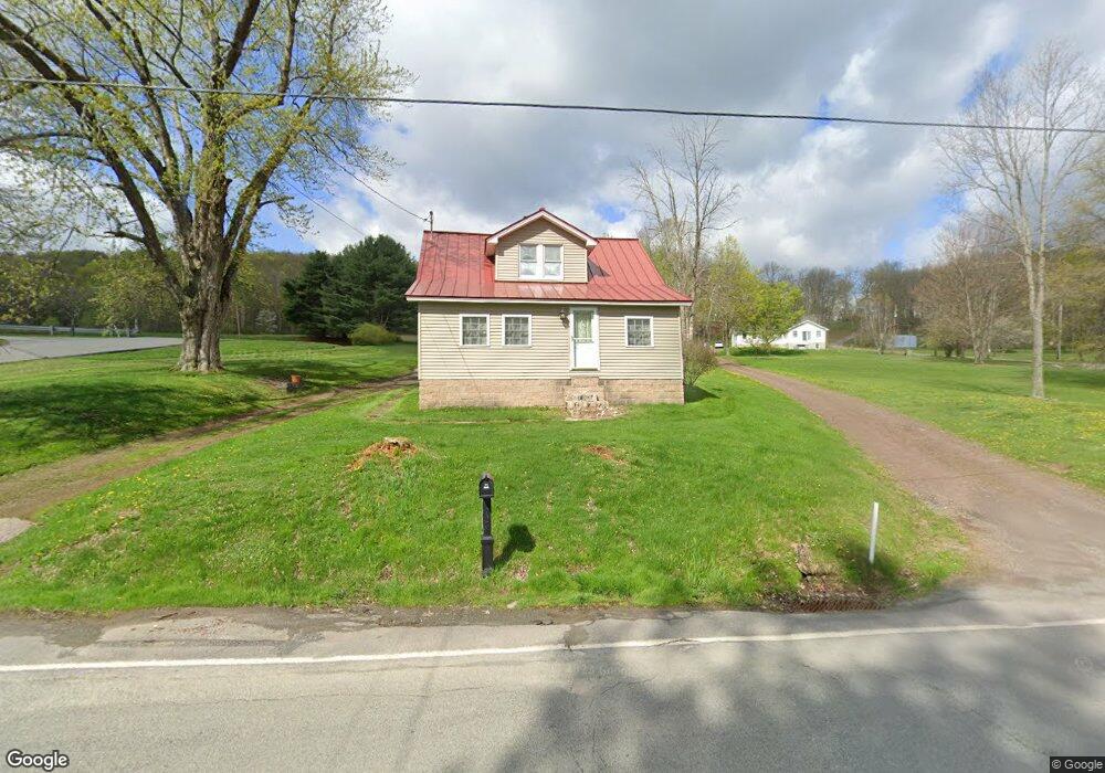
684 Montdale Rd Scott Township, PA 18447
Estimated Value: $173,663 - $339,000
--
Bed
--
Bath
--
Sq Ft
9,670
Sq Ft Lot
About This Home
This home is located at 684 Montdale Rd, Scott Township, PA 18447 and is currently estimated at $283,416. 684 Montdale Rd is a home located in Lackawanna County with nearby schools including Lakeland Junior/Senior High School.
Ownership History
Date
Name
Owned For
Owner Type
Purchase Details
Closed on
Dec 17, 2018
Sold by
Bridges Phillip and Bridges Yvonne
Bought by
Bridges Phillip and Bridges Yvonne
Current Estimated Value
Home Financials for this Owner
Home Financials are based on the most recent Mortgage that was taken out on this home.
Original Mortgage
$115,768
Outstanding Balance
$73,128
Interest Rate
4.5%
Mortgage Type
New Conventional
Estimated Equity
$210,288
Purchase Details
Closed on
Sep 15, 2006
Sold by
Darbenzio Vincent B
Bought by
Bridges Phillip and Amorine Yvonne
Home Financials for this Owner
Home Financials are based on the most recent Mortgage that was taken out on this home.
Original Mortgage
$26,400
Interest Rate
6.52%
Mortgage Type
Stand Alone Second
Purchase Details
Closed on
Feb 22, 2005
Sold by
Darbenzio Vincent B and Harris Sherrie Lynn
Bought by
Darbenzio Vincent B
Create a Home Valuation Report for This Property
The Home Valuation Report is an in-depth analysis detailing your home's value as well as a comparison with similar homes in the area
Home Values in the Area
Average Home Value in this Area
Purchase History
| Date | Buyer | Sale Price | Title Company |
|---|---|---|---|
| Bridges Phillip | -- | First American Title | |
| Bridges Phillip | $132,000 | None Available | |
| Darbenzio Vincent B | -- | None Available |
Source: Public Records
Mortgage History
| Date | Status | Borrower | Loan Amount |
|---|---|---|---|
| Open | Bridges Phillip | $115,768 | |
| Closed | Bridges Phillip | $26,400 |
Source: Public Records
Tax History Compared to Growth
Tax History
| Year | Tax Paid | Tax Assessment Tax Assessment Total Assessment is a certain percentage of the fair market value that is determined by local assessors to be the total taxable value of land and additions on the property. | Land | Improvement |
|---|---|---|---|---|
| 2025 | $1,462 | $6,000 | $1,000 | $5,000 |
| 2024 | $1,207 | $6,000 | $1,000 | $5,000 |
| 2023 | $1,207 | $6,000 | $1,000 | $5,000 |
| 2022 | $1,164 | $6,000 | $1,000 | $5,000 |
| 2021 | $1,164 | $6,000 | $1,000 | $5,000 |
| 2020 | $1,164 | $6,000 | $1,000 | $5,000 |
| 2019 | $1,104 | $6,000 | $1,000 | $5,000 |
| 2018 | $1,092 | $6,000 | $1,000 | $5,000 |
| 2017 | $1,092 | $6,000 | $1,000 | $5,000 |
| 2016 | $581 | $6,000 | $0 | $0 |
| 2015 | -- | $6,000 | $0 | $0 |
| 2014 | -- | $6,000 | $0 | $0 |
Source: Public Records
Map
Nearby Homes
- 132 Boyarsky Rd
- 831 Montdale Rd
- 1198 Lakeland Dr
- 127 Crooked Pine Ln
- 126 Crooked Pine Ln
- 124 Crooked Pine Ln
- 73 Quinton Rd
- 1900 Greenfield Rd
- 101 Sunset Dr Unit A11
- 0 Craig Rd & Miller Rd
- 166 Silver Maple Dr
- 0 T-443
- 1325 Fairview Rd
- 305 Maggies Rd Unit L B
- 0 Hack Rd Unit GSBSC251411
- 1520 N Abington Rd
- 27 Elm St
- 0 Pennsylvania 247
- 0 Pennsylvania 247 Unit GSBSC253219
- 806 Justus Blvd