Estimated Value: $512,000 - $537,000
3
Beds
2
Baths
1,531
Sq Ft
$339/Sq Ft
Est. Value
About This Home
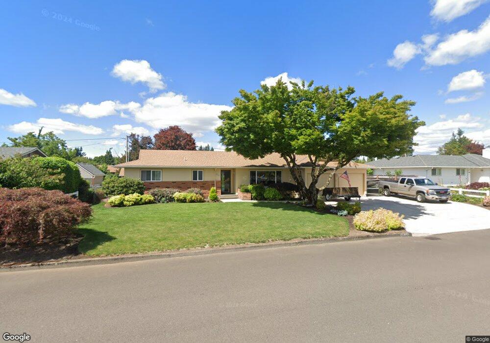
This home is located at 684 NW 12th Ave, Canby, OR 97013 and is currently estimated at $519,755, approximately $339 per square foot. 684 NW 12th Ave is a home located in Clackamas County with nearby schools including Josefa L. Sambrano Elementary School, Baker Prairie Middle School, and Canby High School.
Ownership History
Date
Name
Owned For
Owner Type
Purchase Details
Closed on
Feb 27, 2019
Sold by
Guild Wayne and Guild Barbara
Bought by
Guild Wayne Arthur and Guild Barbara Ann
Current Estimated Value
Purchase Details
Closed on
Apr 20, 2018
Sold by
Hafdahl Myron Ray
Bought by
Guild Wayne and Guild Barbara
Purchase Details
Closed on
Apr 19, 2018
Sold by
Hafdahl Steven Ray and Longworth Marie
Bought by
Hafdahl Myron Ray
Purchase Details
Closed on
Dec 12, 2010
Sold by
Hafdahl Myron Ray and Hafdahl Judith Allene
Bought by
Hafdahl Myron Ray and Denney Marie Ann
Create a Home Valuation Report for This Property
The Home Valuation Report is an in-depth analysis detailing your home's value as well as a comparison with similar homes in the area
Home Values in the Area
Average Home Value in this Area
Purchase History
| Date | Buyer | Sale Price | Title Company |
|---|---|---|---|
| Guild Wayne Arthur | -- | None Available | |
| Guild Wayne | $330,000 | Fidelity National Title | |
| Hafdahl Myron Ray | -- | Fidelity National Title | |
| Hafdahl Myron Ray | -- | None Available |
Source: Public Records
Tax History Compared to Growth
Tax History
| Year | Tax Paid | Tax Assessment Tax Assessment Total Assessment is a certain percentage of the fair market value that is determined by local assessors to be the total taxable value of land and additions on the property. | Land | Improvement |
|---|---|---|---|---|
| 2025 | $4,611 | $260,274 | -- | -- |
| 2024 | $4,482 | $252,694 | -- | -- |
| 2023 | $4,482 | $245,334 | $0 | $0 |
| 2022 | $4,122 | $238,189 | $0 | $0 |
| 2021 | $3,970 | $231,252 | $0 | $0 |
| 2020 | $3,899 | $224,517 | $0 | $0 |
| 2019 | $3,713 | $217,978 | $0 | $0 |
| 2018 | $3,630 | $211,629 | $0 | $0 |
| 2017 | $3,538 | $205,465 | $0 | $0 |
| 2016 | $3,420 | $199,481 | $0 | $0 |
| 2015 | $3,302 | $193,671 | $0 | $0 |
| 2014 | $3,207 | $188,030 | $0 | $0 |
Source: Public Records
Map
Nearby Homes
- 0 NW 10th Ave
- 960 N Aspen Ct
- 1614 NW 16th Ave
- 1721 N Hyssop St
- 187 NE 14th Ave
- 184 NE 10th Ave
- 580 N Grant St
- 318 NE 9th Ave
- 442 NW 4th Ave
- 312 NE 14th Ave
- 1751 N Laurelwood Loop
- 1165 NW 22nd Ave
- 1199 NW 22nd Ave
- 1151 NW 22nd Ave
- 589 NW 3rd Ave
- 812 NW 3rd Ave
- 850 NW 3rd Ave
- 2152 N Laurelwood St
- 660 NE 20th Ave
- 1198 SW 1st Ave
- 668 NW 12th Ave
- 710 NW 12th Ave
- 685 NW 13th Ave
- 653 NW 13th Ave
- 703 NW 13th Ave
- 683 NW 12th Ave
- 646 NW 12th Ave
- 750 NW 12th Ave
- 667 NW 12th Ave
- 705 NW 12th Ave
- 743 NW 13th Ave
- 615 NW 12th Ave
- 747 NW 12th Ave
- 730 NW 11th Ave
- 760 NW 11th Ave
- 686 NW 13th Ave
- 680 NW 11th Ave
- 604 NW 12th Ave
- 1200 N Birch St
- 704 NW 13th Ave