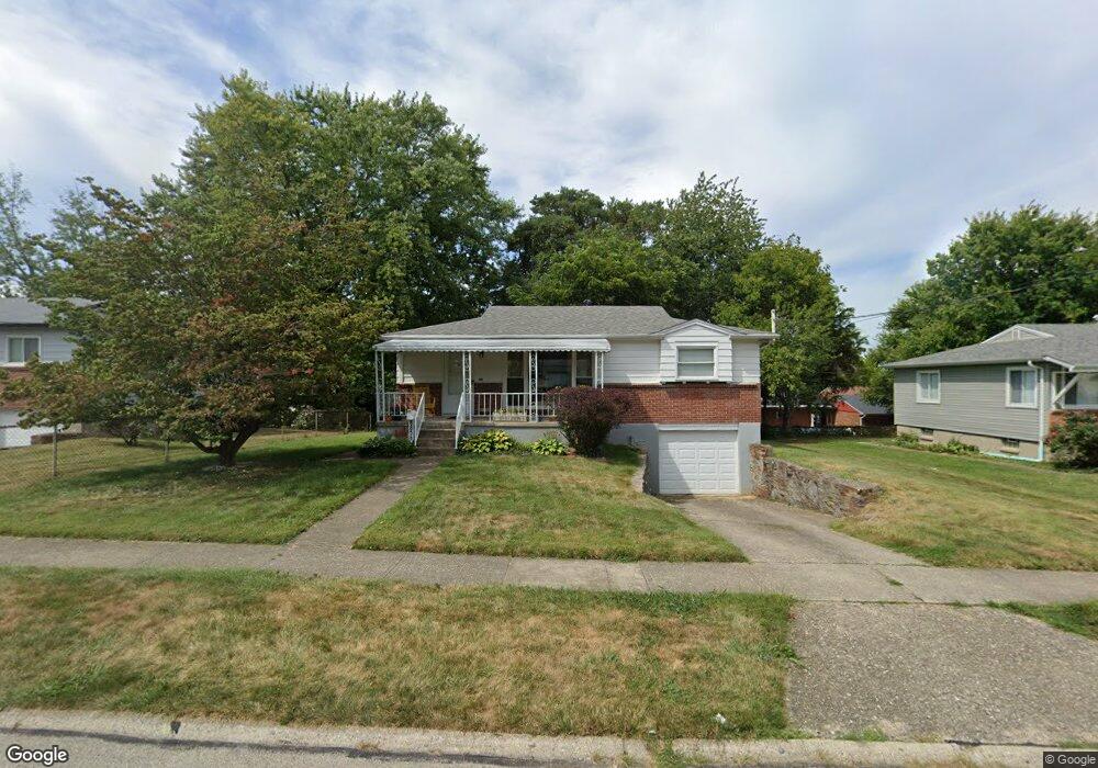
6855 Memory Ln Cincinnati, OH 45239
Estimated Value: $163,440 - $180,000
3
Beds
1
Bath
1,008
Sq Ft
$171/Sq Ft
Est. Value
About This Home
This home is located at 6855 Memory Ln, Cincinnati, OH 45239 and is currently estimated at $172,860, approximately $171 per square foot. 6855 Memory Ln is a home located in Hamilton County with nearby schools including White Oak Middle School, Colerain High School, and Cincinnati Achievement Academy.
Ownership History
Date
Name
Owned For
Owner Type
Purchase Details
Closed on
May 16, 1997
Sold by
Schwierling John T and Rabe Harold W
Bought by
Pellman Teresa C
Current Estimated Value
Home Financials for this Owner
Home Financials are based on the most recent Mortgage that was taken out on this home.
Original Mortgage
$64,990
Outstanding Balance
$7,367
Interest Rate
8.24%
Estimated Equity
$165,493
Create a Home Valuation Report for This Property
The Home Valuation Report is an in-depth analysis detailing your home's value as well as a comparison with similar homes in the area
Home Values in the Area
Average Home Value in this Area
Purchase History
| Date | Buyer | Sale Price | Title Company |
|---|---|---|---|
| Pellman Teresa C | $67,000 | -- |
Source: Public Records
Mortgage History
| Date | Status | Borrower | Loan Amount |
|---|---|---|---|
| Open | Pellman Teresa C | $64,990 |
Source: Public Records
Tax History
| Year | Tax Paid | Tax Assessment Tax Assessment Total Assessment is a certain percentage of the fair market value that is determined by local assessors to be the total taxable value of land and additions on the property. | Land | Improvement |
|---|---|---|---|---|
| 2025 | $2,143 | $37,062 | $7,931 | $29,131 |
| 2023 | $1,999 | $37,062 | $7,931 | $29,131 |
| 2022 | $1,557 | $23,506 | $6,202 | $17,304 |
| 2021 | $1,544 | $23,506 | $6,202 | $17,304 |
| 2020 | $1,560 | $23,506 | $6,202 | $17,304 |
| 2019 | $1,418 | $19,922 | $5,257 | $14,665 |
| 2018 | $1,273 | $19,922 | $5,257 | $14,665 |
| 2017 | $1,206 | $19,922 | $5,257 | $14,665 |
| 2016 | $1,426 | $23,296 | $7,231 | $16,065 |
| 2015 | $1,440 | $23,296 | $7,231 | $16,065 |
| 2014 | $1,443 | $23,296 | $7,231 | $16,065 |
| 2013 | $1,491 | $25,323 | $7,861 | $17,462 |
Source: Public Records
Map
Nearby Homes
- 6751 Rutherford Ct
- 2757 Banning Rd
- 2427 Crosley Meadow
- 2806 Breezy Way
- 2836 Banning Rd
- 2391 Deblin Dr
- 2424 Banning Rd
- 2528 Flanigan Ct
- 2801 Byrneside Dr
- 7560 Pippin Rd
- 5970 Colerain Ave
- 2342 Banning Rd
- 2564 Altura Dr
- 3131 Preserve Ln
- 2680 Royal Glen Dr
- 2603 Kipling Ave
- 3140 Banning Rd
- 6381 Golfway Dr
- 3181 Preserve Ln
- 3181 Preserve Ln Unit 1C
- 6885 Memory Ln
- 6827 Memory Ln
- 6850 Rutherford Ct
- 6880 Rutherford Ct
- 6913 Memory Ln
- 6820 Rutherford Ct
- 6797 Memory Ln
- 6854 Memory Ln
- 6884 Memory Ln
- 6826 Memory Ln
- 6910 Rutherford Ct
- 6780 Rutherford Ct
- 6931 Memory Ln
- 6912 Memory Ln
- 6796 Memory Ln
- 6779 Memory Ln
- 6863 Grange Ct
- 6940 Rutherford Ct
- 6837 Grange Ct
- 6881 Rutherford Ct
Your Personal Tour Guide
Ask me questions while you tour the home.