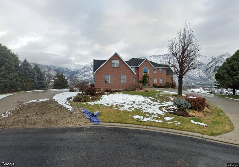
686 Hillside Cir Alpine, UT 84004
Estimated Value: $1,199,000 - $1,733,000
4
Beds
5
Baths
5,602
Sq Ft
$252/Sq Ft
Est. Value
About This Home
This home is located at 686 Hillside Cir, Alpine, UT 84004 and is currently estimated at $1,411,155, approximately $251 per square foot. 686 Hillside Cir is a home located in Utah County with nearby schools including Westfield School, Timberline Middle School, and Lone Peak High School.
Ownership History
Date
Name
Owned For
Owner Type
Purchase Details
Closed on
Feb 5, 2025
Sold by
Nielson Dwayne O and Nielson Sandra L
Bought by
Dwayne O Nielson Revocable Trust and Sandra L Nielson Revocable Trust
Current Estimated Value
Purchase Details
Closed on
Aug 26, 1996
Sold by
Antonelli J Anthony and Antonelli Elizabeth A
Bought by
Nielson Dwayne O and Nielson Sandra L
Home Financials for this Owner
Home Financials are based on the most recent Mortgage that was taken out on this home.
Original Mortgage
$350,000
Interest Rate
8.23%
Mortgage Type
Purchase Money Mortgage
Purchase Details
Closed on
Jul 31, 1996
Sold by
Dearden Rex L and Dearden Wendy
Bought by
Antonelli J Anthony and Antonelli Elizabeth A
Home Financials for this Owner
Home Financials are based on the most recent Mortgage that was taken out on this home.
Original Mortgage
$350,000
Interest Rate
8.23%
Mortgage Type
Purchase Money Mortgage
Create a Home Valuation Report for This Property
The Home Valuation Report is an in-depth analysis detailing your home's value as well as a comparison with similar homes in the area
Home Values in the Area
Average Home Value in this Area
Purchase History
| Date | Buyer | Sale Price | Title Company |
|---|---|---|---|
| Dwayne O Nielson Revocable Trust | -- | None Listed On Document | |
| Nielson Dwayne O | -- | Provo Land Title | |
| Antonelli J Anthony | -- | -- |
Source: Public Records
Mortgage History
| Date | Status | Borrower | Loan Amount |
|---|---|---|---|
| Previous Owner | Nielson Dwayne O | $350,000 | |
| Previous Owner | Antonelli J Anthony | $427,500 |
Source: Public Records
Tax History
| Year | Tax Paid | Tax Assessment Tax Assessment Total Assessment is a certain percentage of the fair market value that is determined by local assessors to be the total taxable value of land and additions on the property. | Land | Improvement |
|---|---|---|---|---|
| 2025 | $4,853 | $596,420 | -- | -- |
| 2024 | $4,853 | $565,565 | $0 | $0 |
| 2023 | $4,619 | $577,940 | $0 | $0 |
| 2022 | $4,300 | $522,555 | $0 | $0 |
| 2021 | $3,760 | $709,800 | $285,200 | $424,600 |
| 2020 | $3,532 | $652,400 | $248,000 | $404,400 |
| 2019 | $3,381 | $652,100 | $247,700 | $404,400 |
| 2018 | $3,172 | $604,500 | $227,900 | $376,600 |
| 2017 | $2,851 | $289,135 | $0 | $0 |
| 2016 | $2,982 | $281,875 | $0 | $0 |
| 2015 | $2,769 | $247,610 | $0 | $0 |
| 2014 | $2,657 | $235,070 | $0 | $0 |
Source: Public Records
Map
Nearby Homes
- 353 International Way
- 820 Eagleview Dr
- 151 Glacier Lily Dr
- 248 Deerfield Dr
- 501 W Devey Dr
- 684 N Summit Way
- 475 Grove Dr
- 19 E Elk Ct
- 512 Eastridge Cir
- 128 E Deer Crest Ln Unit 304
- 48 N 100 E
- 30 S Main St
- 287 Heritage Hills Dr
- 381 E Watkins Cir Unit 28
- 102 E Deer Crest Ln
- 382 E Heritage Hills Dr
- 499 E 300 N
- 522 N Pfeifferhorn Dr
- 463 Heritage Hills Dr
- 1319 N Eastview Ln Unit 214
- 216 Hillside Cir
- 658 Hillside Cir
- 658 Hillside Cir Unit Basement
- 232 Hillside Cir
- 233 Hillside Cir
- 648 Hillside Cir
- 246 Hillside Cir
- 649 Hillside Cir
- 251 Hillside Cir
- 262 Hillside Cir
- 631 N Hillside Dr
- 631 Hillside Cir
- 628 Hillside Cir
- 269 Hillside Cir
- 380 Hillside Cir
- 276 Hillside Cir
- 278 Hillside Cir
- 613 Hillside Cir
- 751 N Fort Creek Landing
- 598 Hillside Cir
Your Personal Tour Guide
Ask me questions while you tour the home.