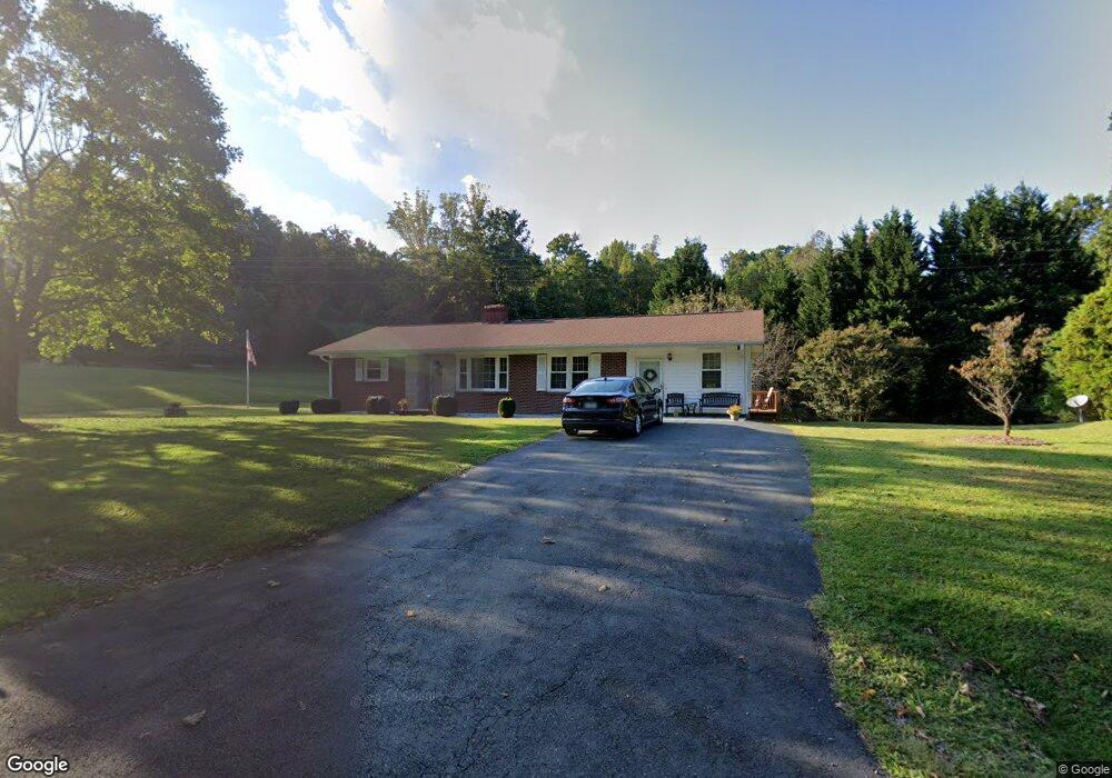
687 Woodville Rd Mount Airy, NC 27030
Estimated Value: $227,000 - $293,000
3
Beds
1
Bath
1,500
Sq Ft
$167/Sq Ft
Est. Value
About This Home
This home is located at 687 Woodville Rd, Mount Airy, NC 27030 and is currently estimated at $250,419, approximately $166 per square foot. 687 Woodville Rd is a home located in Surry County with nearby schools including Westfield Elementary School, Pilot Mountain Middle School, and East Surry High School.
Ownership History
Date
Name
Owned For
Owner Type
Purchase Details
Closed on
Nov 19, 2024
Sold by
Chilton Patsy Ann and Chilton Bernie Walter
Bought by
Chilton Patsy Ann and Chilton Bernie Walter
Current Estimated Value
Purchase Details
Closed on
Aug 16, 2010
Sold by
Chilton Pearl Lewis and Chilton Barry H
Bought by
Chilton Bernie W and Chilton Patsy
Purchase Details
Closed on
May 1, 1963
Create a Home Valuation Report for This Property
The Home Valuation Report is an in-depth analysis detailing your home's value as well as a comparison with similar homes in the area
Home Values in the Area
Average Home Value in this Area
Purchase History
| Date | Buyer | Sale Price | Title Company |
|---|---|---|---|
| Chilton Patsy Ann | $6,000 | None Listed On Document | |
| Chilton Patsy Ann | $6,000 | None Listed On Document | |
| Chilton Patsy Ann | $6,000 | None Listed On Document | |
| Chilton Bernie W | -- | None Available | |
| -- | -- | -- |
Source: Public Records
Tax History Compared to Growth
Tax History
| Year | Tax Paid | Tax Assessment Tax Assessment Total Assessment is a certain percentage of the fair market value that is determined by local assessors to be the total taxable value of land and additions on the property. | Land | Improvement |
|---|---|---|---|---|
| 2025 | $1,102 | $178,280 | $23,560 | $154,720 |
| 2024 | $902 | $131,040 | $21,740 | $109,300 |
| 2023 | $887 | $131,040 | $21,740 | $109,300 |
| 2022 | $887 | $131,040 | $21,740 | $109,300 |
| 2021 | $902 | $131,040 | $21,740 | $109,300 |
| 2020 | $864 | $121,510 | $21,740 | $99,770 |
| 2019 | $861 | $121,510 | $0 | $0 |
| 2018 | $829 | $121,510 | $0 | $0 |
| 2017 | $815 | $121,510 | $0 | $0 |
| 2016 | $815 | $121,510 | $0 | $0 |
| 2013 | -- | $122,380 | $0 | $0 |
Source: Public Records
Map
Nearby Homes
- 7.8ac Norman Rd
- 00 Albion Church Rd
- 140 Daniels Dell Ln
- Lot 4,5,6 Sideview Ln
- 0 Norman Rd
- 733 Slate Mountain Rd
- 203 Brannock Ln
- 1507 Rogers Rd
- 1305 Brim Rd
- 107 Cory Trail
- TBD Rogers Rd Unit TBD Rogers Road
- 0 Sunset Ridge Rd
- 00 Blue Hollow Rd Unit 5
- 583 Snody Rd
- 731 Indian Grove Church Rd
- 1311 Flippin Rd
- 0 Blue Hollow Rd Unit 33 1176021
- 0 Blue Hollow Rd Unit 23105199
- 000 Blue Hollow Rd Unit 27
- 0 Joyce Acres Rd
- 715 Woodville Rd
- 541 Woodville Rd
- x Woodville Rd
- 635 Woodville Rd
- 551 Campbell Rd
- 0 Woodville Rd
- 789 Woodville Rd
- 490 Campbell Rd
- 591 Woodville Rd
- 538 Woodville Rd
- - Woodville Rd
- 399 Campbell Rd
- 310 Brown Rd
- 148 Swansboro Ln
- 000 Swansboro Ln
- 464 Campbell Rd
- 515 Woodville Rd
- 797 Woodville Rd
- 309 Brown Rd
- 887 Woodville Rd