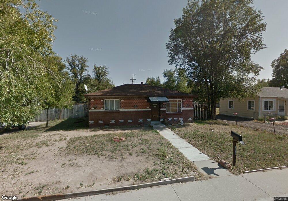
6880 Locust St Commerce City, CO 80022
Tichy NeighborhoodEstimated Value: $336,000 - $347,017
2
Beds
1
Bath
806
Sq Ft
$425/Sq Ft
Est. Value
About This Home
This home is located at 6880 Locust St, Commerce City, CO 80022 and is currently estimated at $342,754, approximately $425 per square foot. 6880 Locust St is a home located in Adams County with nearby schools including Kemp Elementary School, Kearney Middle School, and Adams City High School.
Ownership History
Date
Name
Owned For
Owner Type
Purchase Details
Closed on
Mar 28, 2002
Sold by
Franklin Theodore
Bought by
Garcia Luis
Current Estimated Value
Home Financials for this Owner
Home Financials are based on the most recent Mortgage that was taken out on this home.
Original Mortgage
$142,980
Outstanding Balance
$59,356
Interest Rate
6.83%
Mortgage Type
FHA
Estimated Equity
$283,398
Purchase Details
Closed on
Dec 5, 1995
Sold by
Sweet Lois and Franklin Theodore
Bought by
Franklin Theodore
Create a Home Valuation Report for This Property
The Home Valuation Report is an in-depth analysis detailing your home's value as well as a comparison with similar homes in the area
Home Values in the Area
Average Home Value in this Area
Purchase History
| Date | Buyer | Sale Price | Title Company |
|---|---|---|---|
| Garcia Luis | $145,000 | -- | |
| Franklin Theodore | -- | -- |
Source: Public Records
Mortgage History
| Date | Status | Borrower | Loan Amount |
|---|---|---|---|
| Open | Garcia Luis | $142,980 |
Source: Public Records
Tax History Compared to Growth
Tax History
| Year | Tax Paid | Tax Assessment Tax Assessment Total Assessment is a certain percentage of the fair market value that is determined by local assessors to be the total taxable value of land and additions on the property. | Land | Improvement |
|---|---|---|---|---|
| 2024 | $1,920 | $20,440 | $5,310 | $15,130 |
| 2023 | $1,689 | $23,140 | $5,750 | $17,390 |
| 2022 | $1,669 | $18,570 | $5,770 | $12,800 |
| 2021 | $1,693 | $18,570 | $5,770 | $12,800 |
| 2020 | $1,543 | $17,130 | $5,010 | $12,120 |
| 2019 | $1,540 | $17,130 | $5,010 | $12,120 |
| 2018 | $1,217 | $13,180 | $4,460 | $8,720 |
| 2017 | $1,156 | $13,180 | $4,460 | $8,720 |
| 2016 | $873 | $9,630 | $2,470 | $7,160 |
| 2015 | $890 | $9,630 | $2,470 | $7,160 |
| 2014 | $760 | $8,190 | $2,230 | $5,960 |
Source: Public Records
Map
Nearby Homes
- 6420 E 68th Ave
- 6751 Leyden St
- 7050 Kearney Ct
- 6980 Niagara St
- 6721 Leyden St
- 6711 Leyden St
- 6601 E 71st Ave
- 5971 E 69th Ave
- 5971 E 69th Ave Unit 21
- 6625 Locust St
- 0 Lot 2 Unit REC2976963
- 6251 E 66th Place
- 7131 Pontiac St
- 5680 E 67th Ave
- 7131 Holly St
- 7030 Grape St
- 6681 Holly St
- 6911 Weiman Ct
- 6446 Monaco St
- 6641 E 73rd Place
- 6450 E 69th Ave
- 6870 Locust St
- 6460 E 69th Ave
- 6881 Locust St
- 6871 Locust St
- 6860 Locust St
- 6861 Locust St
- 6910 Locust St
- 6851 Locust St
- 6853 Monaco St
- 6912 Locust Ct
- 6850 Locust St
- 6911 Locust St
- 6916 Locust Ct
- 6465 E 69th Ave
- 6841 Locust St
- 6891 Monaco St
- 6860 Leyden St
- 6895 Monaco St
- 6850 Leyden St