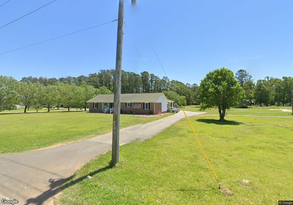
6885 Kates Bay Hwy Conway, SC 29527
Estimated Value: $288,664 - $384,000
3
Beds
1
Bath
1,829
Sq Ft
$189/Sq Ft
Est. Value
About This Home
This home is located at 6885 Kates Bay Hwy, Conway, SC 29527 and is currently estimated at $344,916, approximately $188 per square foot. 6885 Kates Bay Hwy is a home with nearby schools including Pee Dee Elementary School, Whittemore Park Middle School, and Conway High School.
Ownership History
Date
Name
Owned For
Owner Type
Purchase Details
Closed on
Mar 3, 2015
Sold by
Tindall Michael E and Tindall Bonnie G
Bought by
Crossley Robert A and Crossley Lori A
Current Estimated Value
Purchase Details
Closed on
Feb 15, 2013
Sold by
Tindall Michael E
Bought by
Tindall Michael E
Purchase Details
Closed on
Apr 1, 1999
Sold by
Tindall Michael E
Bought by
Tindall Michael E and Tindall Bonnie G
Purchase Details
Closed on
Mar 30, 1999
Sold by
Tindall Michael E and Estate Of Carla H Tindall
Bought by
Tindall Michael E
Create a Home Valuation Report for This Property
The Home Valuation Report is an in-depth analysis detailing your home's value as well as a comparison with similar homes in the area
Home Values in the Area
Average Home Value in this Area
Purchase History
| Date | Buyer | Sale Price | Title Company |
|---|---|---|---|
| Crossley Robert A | $180,000 | -- | |
| Tindall Michael E | -- | -- | |
| Tindall Michael E | -- | -- | |
| Tindall Michael E | -- | -- |
Source: Public Records
Tax History Compared to Growth
Tax History
| Year | Tax Paid | Tax Assessment Tax Assessment Total Assessment is a certain percentage of the fair market value that is determined by local assessors to be the total taxable value of land and additions on the property. | Land | Improvement |
|---|---|---|---|---|
| 2024 | -- | $17,261 | $5,293 | $11,968 |
| 2023 | $0 | $5,900 | $980 | $4,920 |
| 2021 | $89 | $8,849 | $1,469 | $7,380 |
| 2020 | $51 | $8,849 | $1,469 | $7,380 |
| 2019 | $44 | $8,849 | $1,469 | $7,380 |
| 2018 | $44 | $10,199 | $1,211 | $8,988 |
| 2017 | $29 | $10,199 | $1,211 | $8,988 |
| 2016 | $0 | $10,199 | $1,211 | $8,988 |
| 2015 | -- | $7,704 | $1,212 | $6,492 |
| 2014 | $29 | $7,704 | $1,212 | $6,492 |
Source: Public Records
Map
Nearby Homes
- 6572 Elbow Rd Unit Lot C Melanie
- 6580 Elbow Rd Unit Lot D Madalyn
- 232 Harvest Ridge Way
- 544 Scarlet Sage Dr
- 540 Scarlet Sage Dr
- 297 Harvest Ridge Way
- 343 Black Gum Dr
- 380 Harvest Ridge Way
- 331 Black Gum Dr
- 131 Coralberry Dr
- 327 Black Gum Dr
- 123 Coralberry Dr
- 318 Black Gum Dr
- 128 Coralberry Dr
- 310 Black Gum Dr
- ARIA Plan at Dove Crossing
- CALI Plan at Dove Crossing
- MANNING Plan at Dove Crossing
- KERRY Plan at Dove Crossing
- GALEN Plan at Dove Crossing
- 6385 Kates Bay Hwy
- 6375 Kates Bay Hwy
- 6441 Kates Bay Hwy
- 6425 Elbow Rd
- 6420 Charlies Rd
- 6363 Kates Bay Hwy
- Lot 4 Elbow Rd
- Lot 3 Elbow Rd
- Lot 3 Elbow Rd Unit Cates Bay HWY/Elbow
- Lot 4 Elbow Rd Unit Cates Bay HWY/Elbow
- Lot 5 Elbow Rd Unit Cates Bay HWY/Elbow
- Lot 2 Elbow Rd
- Lot 2 Elbow Rd Unit Cates Bay HWY/Elbow
- 6453 Kates Bay Hwy Unit The Hannah
- 6453 Kates Bay Hwy
- 6433 Elbow Rd
- TBD Cates Bay Hwy Unit Lot 4
- TBD Cates Bay Hwy Unit Lot 3
- TBD Cates Bay Hwy Unit Lot 2
- TBD Cates Bay Hwy Unit Tract B