
Seller's Agent in 2026
Dylan Stephens
Stratum Real Estate Group PLLC South Branch Office
(435) 592-0464
1 in this area
43 Total Sales

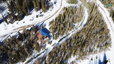

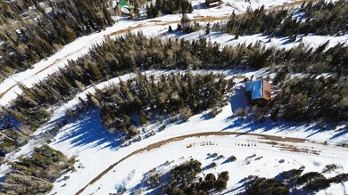


Last available lot on Navajo Ridge Under $200k. Build-ready for the 2026 season! Discover your own mountain getaway on this 0.32-acre lot in Brian Head. Perched for endless views, this property offers easy access to Brian Head Ski Resort and year-round adventure. The natural slope is ideal for a walk-out basement, giving you great design options for a future cabin. Located on a maintained road with utilities in the street, it's a prime spot to build or invest in high-alpine living.
Last Agent to Sell the Property
Stratum Real Estate Group PLLC South Branch Office License #13211136-SA00 Listed on: 11/25/2025
We collect this data history from publicly available records. To have your information removed, we recommend requesting removal directly through your county’s website.
| Date | Type | Sale Price | Title Company |
|---|---|---|---|
| Warranty Deed | -- | American First Escrow & Title | |
| Warranty Deed | -- | Cedar Land Title | |
| Warranty Deed | -- | Cedar Land Title | |
| Warranty Deed | -- | Cedar Land Title | |
| Warranty Deed | -- | Cedar Land Title | |
| Quit Claim Deed | -- | -- |
We collect this data history from publicly available records. To have your information removed, we recommend requesting removal directly through your county’s website.
| Date | Status | Loan Amount | Loan Type |
|---|---|---|---|
| Previous Owner | $24,000 | Balloon | |
| Previous Owner | $24,000 | Balloon |
| Date | Event | Price | List to Sale | Price per Sq Ft |
|---|---|---|---|---|
| 03/24/2026 03/24/26 | Sold | -- | -- | -- |
| 03/12/2026 03/12/26 | Pending | -- | -- | -- |
| 03/04/2026 03/04/26 | Price Changed | $104,000 | -1.9% | -- |
| 11/25/2025 11/25/25 | For Sale | $106,000 | -- | -- |
Seller's Agent in 2026
Dylan Stephens
Stratum Real Estate Group PLLC South Branch Office
(435) 592-0464
1 in this area
43 Total Sales
T
Buyer's Agent in 2026
Taizsha Robinson
High Country Realty-South Brian Head
(805) 312-6020
54 in this area
58 Total Sales
Source: Iron County Board of REALTORS®
MLS Number: 113930
APN: A-1165-0003-0002-06
Ask me questions while you tour the home.