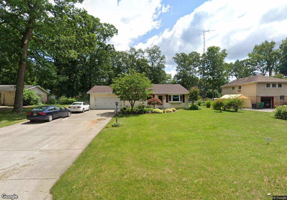
68923 6th St Edwardsburg, MI 49112
Estimated Value: $314,000 - $384,000
3
Beds
2
Baths
1,505
Sq Ft
$235/Sq Ft
Est. Value
About This Home
This home is located at 68923 6th St, Edwardsburg, MI 49112 and is currently estimated at $353,790, approximately $235 per square foot. 68923 6th St is a home located in Cass County with nearby schools including Eagle Lake Elementary School, Edwardsburg Primary School, and Edwardsburg Intermediate School.
Ownership History
Date
Name
Owned For
Owner Type
Purchase Details
Closed on
Jun 15, 2023
Sold by
Ake Donald and Ake Robyn
Bought by
Amos Family Trust
Current Estimated Value
Purchase Details
Closed on
Aug 16, 2016
Sold by
Fifth Third Bank
Bought by
Ake Donald and Ake Robyn
Home Financials for this Owner
Home Financials are based on the most recent Mortgage that was taken out on this home.
Original Mortgage
$121,900
Interest Rate
3.45%
Purchase Details
Closed on
Jul 24, 2008
Sold by
Daly Donald F and Daly Charmayne S
Bought by
Ake Donald and Ake Robyn
Home Financials for this Owner
Home Financials are based on the most recent Mortgage that was taken out on this home.
Original Mortgage
$121,100
Interest Rate
6.36%
Mortgage Type
Purchase Money Mortgage
Create a Home Valuation Report for This Property
The Home Valuation Report is an in-depth analysis detailing your home's value as well as a comparison with similar homes in the area
Home Values in the Area
Average Home Value in this Area
Purchase History
| Date | Buyer | Sale Price | Title Company |
|---|---|---|---|
| Amos Family Trust | $348,000 | Near North Title | |
| Amos Family Trust | $348,000 | Near North Title | |
| Ake Donald | -- | -- | |
| Ake Donald | $173,000 | Meridian Title Corp |
Source: Public Records
Mortgage History
| Date | Status | Borrower | Loan Amount |
|---|---|---|---|
| Previous Owner | Ake Donald | $121,900 | |
| Previous Owner | Ake Donald | -- | |
| Previous Owner | Ake Donald | $121,100 |
Source: Public Records
Tax History Compared to Growth
Tax History
| Year | Tax Paid | Tax Assessment Tax Assessment Total Assessment is a certain percentage of the fair market value that is determined by local assessors to be the total taxable value of land and additions on the property. | Land | Improvement |
|---|---|---|---|---|
| 2025 | $6,140 | $142,800 | $142,800 | $0 |
| 2024 | $1,454 | $137,700 | $137,700 | $0 |
| 2023 | $633 | $111,900 | $0 | $0 |
| 2022 | $603 | $101,200 | $0 | $0 |
| 2021 | $1,481 | $93,600 | $0 | $0 |
| 2020 | $1,473 | $85,700 | $0 | $0 |
| 2019 | $1,421 | $80,700 | $0 | $0 |
| 2018 | $555 | $69,500 | $0 | $0 |
| 2017 | $489 | $46,900 | $0 | $0 |
| 2016 | $484 | $47,300 | $0 | $0 |
| 2015 | -- | $48,300 | $0 | $0 |
| 2011 | -- | $48,400 | $0 | $0 |
Source: Public Records
Map
Nearby Homes
- 68863 6th St
- 68881 3rd St
- 69054 Brady Rd
- 24029 S Shore Dr
- 23876 S Shore Dr
- 23671 S Shore Dr
- 68738 S Shore Dr
- 23650 S Shore Dr
- 68800 S Shore Dr
- 69025 Island Dr
- 69050 Island Dr
- 23276 S Shore Dr
- 24199 N Shore Dr
- 68270 N Shore Dr
- 68575 W Banks Dr
- 23836 N Shore Dr
- 23838 N Shore Dr
- 68149 Lawndale St
- 23675 N Shore Dr
- 23684 N Shore Dr