Estimated Value: $885,000 - $1,303,000
6
Beds
3
Baths
4,314
Sq Ft
$244/Sq Ft
Est. Value
About This Home
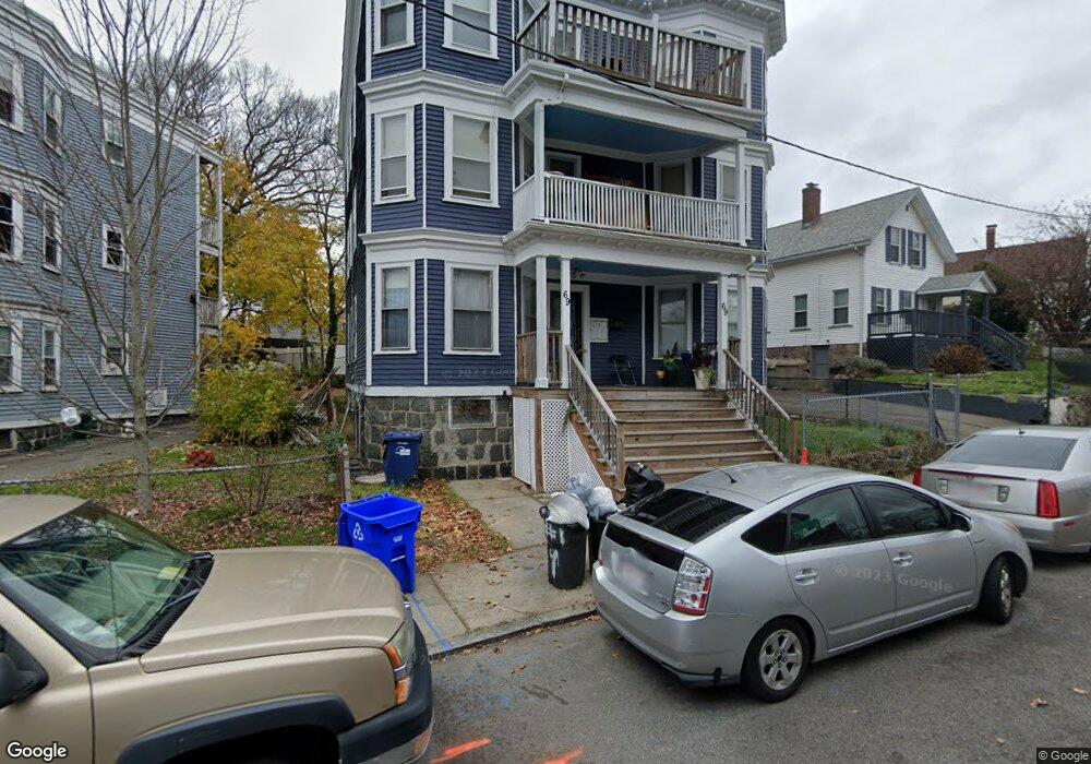
This home is located at 69 Bird St, Dorchester, MA 02125 and is currently estimated at $1,054,667, approximately $244 per square foot. 69 Bird St is a home located in Suffolk County with nearby schools including Boston Collegiate Charter School, Pope John Paul II Catholic Academy Columbia Campus, and Uncommon Schools Roxbury Prep Dorchester Campus.
Ownership History
Date
Name
Owned For
Owner Type
Purchase Details
Closed on
Feb 21, 1997
Sold by
Geoghegan Mary M and Geoghegan Julianne D
Bought by
Bynum Zachery A
Current Estimated Value
Home Financials for this Owner
Home Financials are based on the most recent Mortgage that was taken out on this home.
Original Mortgage
$121,400
Interest Rate
7.8%
Mortgage Type
Purchase Money Mortgage
Create a Home Valuation Report for This Property
The Home Valuation Report is an in-depth analysis detailing your home's value as well as a comparison with similar homes in the area
Home Values in the Area
Average Home Value in this Area
Purchase History
| Date | Buyer | Sale Price | Title Company |
|---|---|---|---|
| Bynum Zachery A | $122,000 | -- |
Source: Public Records
Mortgage History
| Date | Status | Borrower | Loan Amount |
|---|---|---|---|
| Open | Bynum Zachery A | $52,000 | |
| Open | Bynum Zachery A | $119,000 | |
| Closed | Bynum Zachery A | $119,000 | |
| Closed | Bynum Zachery A | $121,400 |
Source: Public Records
Tax History Compared to Growth
Tax History
| Year | Tax Paid | Tax Assessment Tax Assessment Total Assessment is a certain percentage of the fair market value that is determined by local assessors to be the total taxable value of land and additions on the property. | Land | Improvement |
|---|---|---|---|---|
| 2025 | $12,354 | $1,066,800 | $268,100 | $798,700 |
| 2024 | $10,383 | $952,600 | $265,700 | $686,900 |
| 2023 | $9,137 | $850,700 | $237,300 | $613,400 |
| 2022 | $8,987 | $826,000 | $230,400 | $595,600 |
| 2021 | $8,237 | $772,000 | $215,300 | $556,700 |
| 2020 | $7,417 | $702,400 | $252,000 | $450,400 |
| 2019 | $6,435 | $610,500 | $157,500 | $453,000 |
| 2018 | $5,713 | $545,100 | $157,500 | $387,600 |
| 2017 | $5,345 | $504,700 | $157,500 | $347,200 |
| 2016 | $4,828 | $438,900 | $157,500 | $281,400 |
| 2015 | $4,225 | $348,900 | $113,000 | $235,900 |
| 2014 | $4,260 | $338,600 | $113,000 | $225,600 |
Source: Public Records
Map
Nearby Homes
- 42 Monadnock St
- 173 Magnolia St Unit 5
- 5 Wheelock Ave
- 3 Ware St
- 47 Sargent St Unit 3
- 22 Ronan St
- 96-98 Woodledge St
- 18 Sargent St Unit B
- 20 Rill St
- 60 Stanley St Unit 301
- 60 Stanley St Unit 302
- 60 Stanley St
- 60 Stanley St Unit 101
- 35 Cunningham St
- 52 Bellevue St Unit 1
- 52 Bellevue St Unit 3
- 52 Bellevue St Unit 2
- 106 Sawyer Ave Unit 3
- 53 Woodford St
- 38 Woodford St
- 73 Bird St
- 65 Bird St
- 2 Cedar Place
- 4 Cedar Place
- 79 Bird St
- 61 Bird St
- 6 Cedar Place
- 18 Sayward St
- 72 Bird St Unit 74
- 00 William t Morrissey Blvd
- 1 Cedar Place
- 87 Bird St
- 76-78 Bird St Unit 78
- 76 Bird St Unit 78
- 17 Sayward St
- 69 Monadnock St
- 16 Sayward St
- 68 Bird St Unit 19
- 68 Bird St Unit 18
- 68 Bird St Unit 17