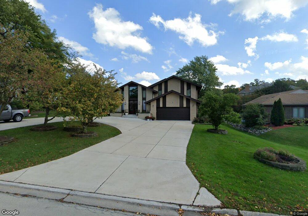
69 Deer Path Trail Burr Ridge, IL 60527
Burr Ridge West NeighborhoodEstimated Value: $914,000 - $1,184,000
--
Bed
1
Bath
4,839
Sq Ft
$221/Sq Ft
Est. Value
About This Home
This home is located at 69 Deer Path Trail, Burr Ridge, IL 60527 and is currently estimated at $1,071,505, approximately $221 per square foot. 69 Deer Path Trail is a home located in DuPage County with nearby schools including Gower West Elementary School, Gower Middle School, and Hinsdale South High School.
Ownership History
Date
Name
Owned For
Owner Type
Purchase Details
Closed on
Sep 2, 1997
Sold by
Ahuja Satya P and Ahuja Jaya
Bought by
Ahuja Satya P and Ahuja Jaya
Current Estimated Value
Create a Home Valuation Report for This Property
The Home Valuation Report is an in-depth analysis detailing your home's value as well as a comparison with similar homes in the area
Home Values in the Area
Average Home Value in this Area
Purchase History
| Date | Buyer | Sale Price | Title Company |
|---|---|---|---|
| Ahuja Satya P | -- | -- |
Source: Public Records
Tax History Compared to Growth
Tax History
| Year | Tax Paid | Tax Assessment Tax Assessment Total Assessment is a certain percentage of the fair market value that is determined by local assessors to be the total taxable value of land and additions on the property. | Land | Improvement |
|---|---|---|---|---|
| 2024 | $15,989 | $344,506 | $113,218 | $231,288 |
| 2023 | $15,311 | $316,700 | $104,080 | $212,620 |
| 2022 | $15,781 | $326,160 | $107,190 | $218,970 |
| 2021 | $15,412 | $325,120 | $105,970 | $219,150 |
| 2020 | $14,071 | $318,680 | $103,870 | $214,810 |
| 2019 | $13,536 | $305,770 | $99,660 | $206,110 |
| 2018 | $14,539 | $337,250 | $99,120 | $238,130 |
| 2017 | $15,818 | $349,990 | $95,380 | $254,610 |
| 2016 | $15,373 | $309,930 | $91,030 | $218,900 |
| 2015 | $15,307 | $291,590 | $85,640 | $205,950 |
| 2014 | $15,702 | $294,050 | $83,270 | $210,780 |
| 2013 | $15,330 | $292,670 | $82,880 | $209,790 |
Source: Public Records
Map
Nearby Homes
- 1 Hidden Lake Dr
- 8141 Ridgepoint Dr
- 8101 S County Line Rd
- 8170 Lake Ridge Dr
- 15W521 81st St
- 7962 S Garfield Ave Unit 110
- 8120 Woodside Ln
- 15W670 83rd St
- 8850 S County Line Rd
- 11901 Heritage Dr
- 8886 Johnston Rd
- 17 Ambriance Dr
- 8010 Greenbriar Ct
- 8980 Enclave Dr
- 8425 S Hickory Ct
- 15W601 89th Place
- 15W601 S Grant St
- 17 Buege Ln
- 11735 Orchard Rd
- 8302 Pleasant View Ave
- 65 Deer Path Trail
- 73 Deer Path Trail
- 70 Deer Path Trail
- 15W151 83rd St
- 61 Deer Path Trail
- 8330 Fars Cove
- 8350 Fars Cove
- 66 Deer Path Trail
- 74 Deer Path Trail
- 62 Deer Path Trail
- 55 Deer Path Trail
- LOT #2 Fars Cove St
- 8223 Windsor Ct
- 8224 Windsor Ct Unit 1
- 8370 Fars Cove
- 58 Deer Path Trail
- 8311 Fars Cove
- 8223 Kathryn Ct
- 8301 Fars Cove
- 8219 Windsor Ct