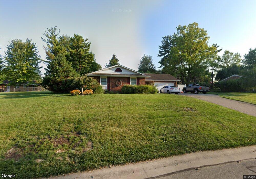
69 Deneen Ave Monroe, OH 45050
Estimated Value: $255,892 - $265,000
3
Beds
1
Bath
1,353
Sq Ft
$193/Sq Ft
Est. Value
About This Home
This home is located at 69 Deneen Ave, Monroe, OH 45050 and is currently estimated at $260,473, approximately $192 per square foot. 69 Deneen Ave is a home located in Butler County with nearby schools including Monroe Primary School, Monroe Elementary School, and Monroe Junior High School.
Ownership History
Date
Name
Owned For
Owner Type
Purchase Details
Closed on
Aug 8, 2014
Sold by
Howard Joseph R
Bought by
Howard Michael R and Howard Michae R
Current Estimated Value
Home Financials for this Owner
Home Financials are based on the most recent Mortgage that was taken out on this home.
Original Mortgage
$60,000
Interest Rate
4.11%
Mortgage Type
Future Advance Clause Open End Mortgage
Purchase Details
Closed on
Jun 25, 2014
Sold by
Howard Joseph R
Bought by
Howard Michael R
Home Financials for this Owner
Home Financials are based on the most recent Mortgage that was taken out on this home.
Original Mortgage
$60,000
Interest Rate
4.11%
Mortgage Type
Future Advance Clause Open End Mortgage
Create a Home Valuation Report for This Property
The Home Valuation Report is an in-depth analysis detailing your home's value as well as a comparison with similar homes in the area
Home Values in the Area
Average Home Value in this Area
Purchase History
| Date | Buyer | Sale Price | Title Company |
|---|---|---|---|
| Howard Michael R | $60,000 | None Available | |
| Howard Michael R | -- | None Available |
Source: Public Records
Mortgage History
| Date | Status | Borrower | Loan Amount |
|---|---|---|---|
| Closed | Howard Michael R | $60,000 |
Source: Public Records
Tax History
| Year | Tax Paid | Tax Assessment Tax Assessment Total Assessment is a certain percentage of the fair market value that is determined by local assessors to be the total taxable value of land and additions on the property. | Land | Improvement |
|---|---|---|---|---|
| 2025 | $2,991 | $66,410 | $11,770 | $54,640 |
| 2024 | $2,991 | $66,410 | $11,770 | $54,640 |
| 2023 | $2,971 | $69,300 | $11,770 | $57,530 |
| 2022 | $2,455 | $48,330 | $11,770 | $36,560 |
| 2021 | $2,365 | $48,330 | $11,770 | $36,560 |
| 2020 | $2,450 | $48,330 | $11,770 | $36,560 |
| 2019 | $2,695 | $39,310 | $12,020 | $27,290 |
| 2018 | $2,151 | $39,310 | $12,020 | $27,290 |
| 2017 | $2,196 | $39,310 | $12,020 | $27,290 |
| 2016 | $2,096 | $35,960 | $12,020 | $23,940 |
| 2015 | $2,072 | $35,960 | $12,020 | $23,940 |
| 2014 | $2,137 | $35,960 | $12,020 | $23,940 |
| 2013 | $2,137 | $37,230 | $12,020 | $25,210 |
Source: Public Records
Map
Nearby Homes
- 415 Brookhurst Dr
- 180 Wexford Dr
- 195 Brittony Woods Dr
- 1416 Wilderness Way Unit 7300
- 921 Heritage Green Dr Unit 9302
- 1753 Weatherstone Cir Unit 13G6
- 316 Wellington Ct
- 100 N Main St
- 220 Gatehouse Ct
- 852 Willowbrook Dr
- 75 Teil Tree Ct
- 132 Village Ct
- VANDERBURGH Plan at Caravel
- SEBASTIAN Plan at Caravel
- ASH LAWN Plan at Caravel
- BENNETT Plan at Caravel
- LYNDHURST Plan at Caravel
- CRESTWOOD Plan at Caravel
- ALDRIDGE Plan at Caravel
- 6893 Gaspar Trail
- 79 Deneen Ave
- 20 Penbrooke Ct
- 34 Penbrooke Ct
- 50 Penbrooke Ct
- 89 Deneen Ave
- 66 Penbrooke Ct
- 78 Deneen Ave
- 64 Deneen Ave
- 54 Deneen Ave
- 80 Penbrooke Ct
- 103 Deneen Ave
- 7 Penbrooke Ct
- 100 Deneen Ave
- 44 Deneen Ave
- 45 Penbrooke Ct
- 27 Penbrooke Ct
- 444 N Sands Ave
- 55 Penbrooke Ct
- 17 Penbrooke Ct
- 29 Heatherwood Ct
Your Personal Tour Guide
Ask me questions while you tour the home.