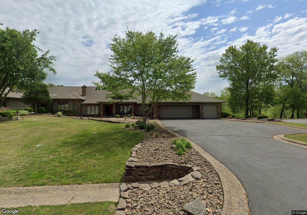
69 Dogwood Dr Bella Vista, AR 72715
Estimated Value: $533,000 - $695,000
2
Beds
3
Baths
3,380
Sq Ft
$173/Sq Ft
Est. Value
About This Home
This home is located at 69 Dogwood Dr, Bella Vista, AR 72715 and is currently estimated at $584,381, approximately $172 per square foot. 69 Dogwood Dr is a home located in Benton County with nearby schools including Cooper Elementary School, Old High Middle School, and Washington Junior High School.
Ownership History
Date
Name
Owned For
Owner Type
Purchase Details
Closed on
Aug 29, 2006
Sold by
Jones Carolyn Kelly Billingsley
Bought by
Reynolds Leona F
Current Estimated Value
Purchase Details
Closed on
Dec 23, 2003
Bought by
Billingsley Rev Tr
Purchase Details
Closed on
Dec 19, 2003
Bought by
Billingsley Rev Trust
Purchase Details
Closed on
May 2, 2002
Bought by
Billingsley
Purchase Details
Closed on
Nov 17, 2001
Bought by
Dod 11-17-2001
Purchase Details
Closed on
Jan 27, 1987
Bought by
Smoot
Create a Home Valuation Report for This Property
The Home Valuation Report is an in-depth analysis detailing your home's value as well as a comparison with similar homes in the area
Home Values in the Area
Average Home Value in this Area
Purchase History
| Date | Buyer | Sale Price | Title Company |
|---|---|---|---|
| Reynolds Leona F | $465,000 | None Available | |
| Billingsley Rev Tr | -- | -- | |
| Billingsley Rev Trust | -- | -- | |
| Billingsley | $350,000 | -- | |
| Dod 11-17-2001 | -- | -- | |
| Smoot | $236,000 | -- |
Source: Public Records
Tax History Compared to Growth
Tax History
| Year | Tax Paid | Tax Assessment Tax Assessment Total Assessment is a certain percentage of the fair market value that is determined by local assessors to be the total taxable value of land and additions on the property. | Land | Improvement |
|---|---|---|---|---|
| 2025 | $5,539 | $93,142 | $13,000 | $80,142 |
| 2024 | $5,026 | $93,142 | $13,000 | $80,142 |
| 2023 | $4,569 | $74,540 | $10,000 | $64,540 |
| 2022 | $3,888 | $74,540 | $10,000 | $64,540 |
| 2021 | $3,878 | $74,540 | $10,000 | $64,540 |
| 2020 | $3,916 | $71,570 | $10,000 | $61,570 |
| 2019 | $3,916 | $71,570 | $10,000 | $61,570 |
| 2018 | $3,941 | $71,570 | $10,000 | $61,570 |
| 2017 | $3,780 | $71,570 | $10,000 | $61,570 |
| 2016 | $3,780 | $71,570 | $10,000 | $61,570 |
| 2015 | $4,062 | $67,370 | $12,500 | $54,870 |
| 2014 | $3,712 | $67,370 | $12,500 | $54,870 |
Source: Public Records
Map
Nearby Homes
- 26 Norwood Dr
- 26 Annette Ln
- 20 Annette Ln
- 5 Mellor Ln
- 11 Mellor Ln
- 19 Mellor Ln
- TBD Coverack Ln
- 35 Dogwood Dr
- Undisclosed Nantucket Dr
- 16 Coverack Ln
- 15 Nantucket Dr
- 0 Kirkwall and Copinsay Unit 1322488
- 43 Britten Cir
- 19 Nantucket Dr
- 4 Nantucket Dr
- 14 Britten Cir
- 76 Overton Dr
- 0 Overton Dr
- 45 Penzance Dr
- 35 Fleetwood Dr