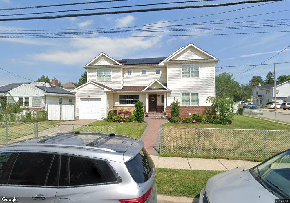
69 Doris Ave Franklin Square, NY 11010
Estimated Value: $940,814 - $1,112,000
3
Beds
3
Baths
2,583
Sq Ft
$397/Sq Ft
Est. Value
About This Home
This home is located at 69 Doris Ave, Franklin Square, NY 11010 and is currently estimated at $1,026,407, approximately $397 per square foot. 69 Doris Ave is a home located in Nassau County with nearby schools including St Anne's School.
Ownership History
Date
Name
Owned For
Owner Type
Purchase Details
Closed on
May 12, 2011
Sold by
Guarino Raymond
Bought by
Johnson Robbie and Johnson Cini
Current Estimated Value
Home Financials for this Owner
Home Financials are based on the most recent Mortgage that was taken out on this home.
Original Mortgage
$288,000
Outstanding Balance
$200,699
Interest Rate
4.94%
Mortgage Type
Purchase Money Mortgage
Estimated Equity
$825,708
Purchase Details
Closed on
Feb 25, 2010
Sold by
Us Bank National Association
Bought by
Guarino Raymond
Purchase Details
Closed on
Dec 18, 2007
Sold by
Rattoballi Anthony J
Purchase Details
Closed on
May 24, 2004
Sold by
Bussa Ardelia
Purchase Details
Closed on
Apr 3, 2002
Purchase Details
Closed on
Feb 17, 1997
Create a Home Valuation Report for This Property
The Home Valuation Report is an in-depth analysis detailing your home's value as well as a comparison with similar homes in the area
Home Values in the Area
Average Home Value in this Area
Purchase History
| Date | Buyer | Sale Price | Title Company |
|---|---|---|---|
| Johnson Robbie | $360,000 | -- | |
| Guarino Raymond | $305,000 | -- | |
| -- | $464,040 | -- | |
| -- | -- | -- | |
| -- | $230,000 | -- | |
| -- | -- | -- |
Source: Public Records
Mortgage History
| Date | Status | Borrower | Loan Amount |
|---|---|---|---|
| Open | Johnson Robbie | $288,000 |
Source: Public Records
Tax History Compared to Growth
Tax History
| Year | Tax Paid | Tax Assessment Tax Assessment Total Assessment is a certain percentage of the fair market value that is determined by local assessors to be the total taxable value of land and additions on the property. | Land | Improvement |
|---|---|---|---|---|
| 2025 | $8,166 | $570 | $149 | $421 |
| 2024 | $2,977 | $565 | $148 | $417 |
| 2023 | $6,114 | $642 | $188 | $454 |
| 2022 | $6,114 | $580 | $152 | $428 |
| 2021 | $5,197 | $470 | $300 | $170 |
| 2020 | $6,904 | $557 | $439 | $118 |
| 2019 | $7,605 | $596 | $440 | $156 |
| 2018 | $7,724 | $636 | $0 | $0 |
| 2017 | $4,588 | $676 | $394 | $282 |
| 2016 | $8,009 | $715 | $417 | $298 |
| 2015 | $3,811 | $806 | $470 | $336 |
| 2014 | $3,811 | $806 | $470 | $336 |
| 2013 | $3,474 | $787 | $470 | $317 |
Source: Public Records
Map
Nearby Homes
- 1134 Rosegold St
- 44 Catherine Ave
- 1116 Theodora St
- 1098 Russell St
- 89 Hunnewell Ave
- 191 Litchfield Ave
- 1041 Russell St
- 31 Evans Ave
- 147 Evans Ave
- 1022 Rosegold St
- 1319 Journal Ave
- 206 Hunnewell Ave
- 62 Herman Blvd
- 280 Franklin Ave Unit 11
- 103 Meacham Ave
- 1314 Globe Ave
- 0 Journal Ave Unit ONE3527047
- 1035 Wool Ave
- 298 Doris Ave
- 51 Pacific St
- 59 Doris Ave
- 1174 Russell St Unit Second Floor
- 1174 Russell St
- 1199 Russell St
- 56 Catherine Ave
- 1170 Russell St
- 53 Doris Ave
- 1185 Russell St
- 1167 Russell St
- 52 Catherine Ave
- 70 Doris Ave
- 62 Doris Ave
- 48 Catherine Ave
- 56 Doris Ave
- 47 Doris Ave
- 80 Catherine Ave
- 81 Doris Ave
- 81 Doris Ave Unit 2
- 1191 Russell St
- 69 Catherine Ave