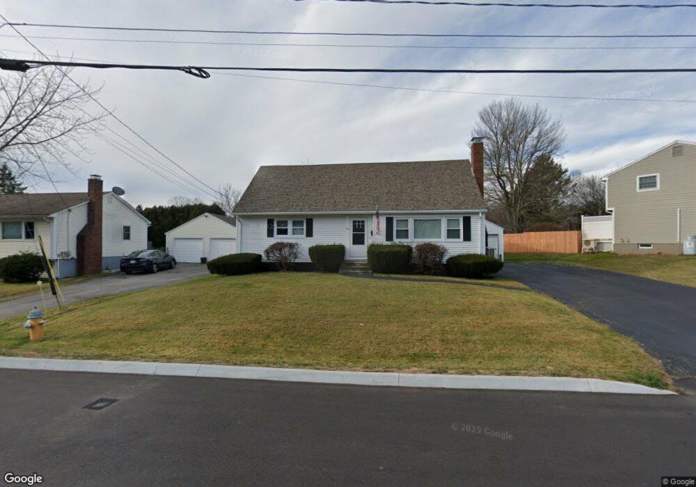
69 Four Winds Rd Portland, ME 04102
Nasons Corner NeighborhoodEstimated Value: $550,821 - $685,000
3
Beds
2
Baths
1,796
Sq Ft
$340/Sq Ft
Est. Value
About This Home
This home is located at 69 Four Winds Rd, Portland, ME 04102 and is currently estimated at $610,205, approximately $339 per square foot. 69 Four Winds Rd is a home located in Cumberland County with nearby schools including Amanda C Rowe School, Lincoln Middle School, and Breakwater School.
Ownership History
Date
Name
Owned For
Owner Type
Purchase Details
Closed on
Nov 3, 2023
Sold by
Brenner Natalie Est and Barrett
Bought by
Brenner Joseph A
Current Estimated Value
Home Financials for this Owner
Home Financials are based on the most recent Mortgage that was taken out on this home.
Original Mortgage
$205,000
Outstanding Balance
$200,836
Interest Rate
7.19%
Mortgage Type
Purchase Money Mortgage
Estimated Equity
$409,369
Create a Home Valuation Report for This Property
The Home Valuation Report is an in-depth analysis detailing your home's value as well as a comparison with similar homes in the area
Home Values in the Area
Average Home Value in this Area
Purchase History
| Date | Buyer | Sale Price | Title Company |
|---|---|---|---|
| Brenner Joseph A | $430,000 | None Available |
Source: Public Records
Mortgage History
| Date | Status | Borrower | Loan Amount |
|---|---|---|---|
| Open | Brenner Joseph A | $205,000 |
Source: Public Records
Tax History Compared to Growth
Tax History
| Year | Tax Paid | Tax Assessment Tax Assessment Total Assessment is a certain percentage of the fair market value that is determined by local assessors to be the total taxable value of land and additions on the property. | Land | Improvement |
|---|---|---|---|---|
| 2024 | $5,863 | $390,600 | $65,200 | $325,400 |
| 2023 | $5,629 | $390,600 | $65,200 | $325,400 |
| 2022 | $5,316 | $390,600 | $65,200 | $325,400 |
| 2021 | $5,074 | $390,600 | $65,200 | $325,400 |
| 2020 | $5,170 | $221,800 | $65,200 | $156,600 |
| 2019 | $5,170 | $221,800 | $65,200 | $156,600 |
| 2018 | $4,986 | $221,800 | $65,200 | $156,600 |
| 2017 | $4,802 | $221,800 | $65,200 | $156,600 |
| 2016 | $4,682 | $221,800 | $65,200 | $156,600 |
| 2015 | $4,576 | $221,800 | $65,200 | $156,600 |
| 2014 | $4,436 | $221,800 | $65,200 | $156,600 |
Source: Public Records
Map
Nearby Homes
- 0 Hillcrest Ave
- 7 Dale Ct
- 63A Capisic St
- 97 Warren Ave
- 96 Holm Ave
- 24 Celebration Ct Unit 13
- 99 Webb St
- 37 Tremont St
- 75 Mcauley Way Unit 307
- 75 Mcauley Way Unit 206
- 75 Mcauley Way Unit 401
- 75 Mcauley Way Unit 207
- 75 Mcauley Way Unit 502
- 75 Mcauley Way Unit 304
- 75 Mcauley Way Unit 301
- 75 Mcauley Way Unit 402
- 75 Mcauley Way Unit 303
- 75 Mcauley Way Unit 504
- 75 Mcauley Way Unit 506
- 75 Mcauley Way Unit 507
- 75 Four Winds Rd
- 68 Four Winds Rd
- 55 Four Winds Rd
- 62 Four Winds Rd
- 51 Four Winds Rd
- 19 Longwood Dr
- 56 Four Winds Rd
- 80 Four Winds Rd
- 11 Longwood Dr
- 29 Sonnet Ln
- 50 Four Winds Rd
- 83 Four Winds Rd
- 25 Longwood Dr
- 43 Four Winds Rd
- 16 Longwood Dr
- 86 Four Winds Rd
- 370 Ludlow St
- 31 Longwood Dr
- 364 Ludlow St
- 105 Four Winds Rd