M
Seller's Agent in 2025
Mike Stuart
Merrimack Realty Group, Chelmsford
(978) 423-3364
1 in this area
21 Total Sales


Estimated Value: $710,000 - $747,000
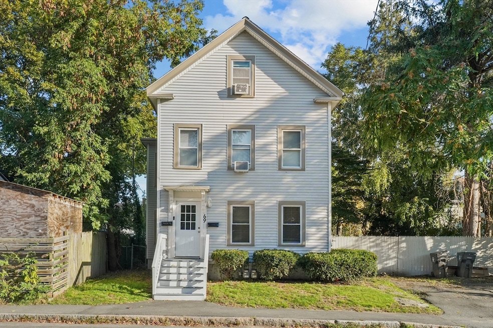
A large two family in the heart of Haverhill is ready for its next chapter. First floor unit offers two bedrooms and a bath with newer flooring, insulation, new heating system, roof, and electrical. The second and third floor unit has 4 beds and 1 bath with also newer electrical, brand new heating system, insulation, flooring, and appliances. First floor is vacant while 2nd/3rd has below market rent at $1700 with TAW. There are two parking spaces and a fenced yard for any pets. With just some light work, these units can garner impressive rents thus making this a money maker. Or live in one and rent the other. Either way its a Win/Win! Open houses start any showings. Bring your offers!!
Last Agent to Sell the Property
Merrimack Realty Group, Chelmsford Listed on: 10/03/2025
Last Buyer's Agent
Jelssy Rosario
View Real Estate Group
We collect this data history from publicly available records. To have your information removed, we recommend requesting removal directly through your county’s website.
| Date | Buyer | Sale Price | Title Company |
|---|---|---|---|
| Guzman-Eustate Pedro | $735,000 | -- | |
| Amt Forest Howard Rlty | -- | None Available | |
| Amt Forest Howard Rlty | -- | None Available | |
| Amt Forest Howard Rlty | -- | None Available | |
| Tilden Adam M | -- | None Available | |
| Tilden Adam | -- | None Available | |
| Tilden Adam M | -- | None Available | |
| Tilden Adam | -- | None Available | |
| Tilden Adam | -- | None Available | |
| Tilden Adam | -- | None Available | |
| Amt Forrest Howard Rea | -- | -- | |
| Rea Amt | -- | -- | |
| Tilden Adam | -- | -- | |
| Tilden Adam | -- | -- | |
| Amt Forrest Howard Rea | -- | -- | |
| Rea Amt | -- | -- | |
| Tilden Adam | -- | -- | |
| Tilden Adam | -- | -- | |
| Tilden Adam | -- | -- | |
| Tilden Adam | $215,000 | -- | |
| Tilden Adam | $215,000 | -- |
We collect this data history from publicly available records. To have your information removed, we recommend requesting removal directly through your county’s website.
| Date | Status | Borrower | Loan Amount |
|---|---|---|---|
| Open | Guzman-Eustate Pedro | $721,687 | |
| Previous Owner | Tilden Adam M | $215,000 | |
| Previous Owner | Tilden Adam | $275,000 |
| Date | Event | Price | List to Sale | Price per Sq Ft |
|---|---|---|---|---|
| 11/24/2025 11/24/25 | Sold | $735,000 | +2.1% | $297 / Sq Ft |
| 10/15/2025 10/15/25 | Pending | -- | -- | -- |
| 10/03/2025 10/03/25 | For Sale | $720,000 | -- | $291 / Sq Ft |
| Year | Tax Paid | Tax Assessment Tax Assessment Total Assessment is a certain percentage of the fair market value that is determined by local assessors to be the total taxable value of land and additions on the property. | Land | Improvement |
|---|---|---|---|---|
| 2025 | $5,412 | $505,300 | $150,800 | $354,500 |
| 2024 | $5,033 | $473,000 | $147,800 | $325,200 |
| 2023 | $4,899 | $439,400 | $147,800 | $291,600 |
| 2022 | $4,793 | $376,800 | $140,300 | $236,500 |
| 2021 | $4,523 | $336,500 | $125,200 | $211,300 |
| 2020 | $4,313 | $317,100 | $117,600 | $199,500 |
| 2019 | $3,980 | $285,300 | $102,600 | $182,700 |
| 2018 | $3,790 | $265,800 | $96,500 | $169,300 |
| 2017 | $3,434 | $229,100 | $93,500 | $135,600 |
| 2016 | $3,195 | $208,000 | $72,400 | $135,600 |
| 2015 | -- | $194,500 | $72,400 | $122,100 |
M
Seller's Agent in 2025
Mike Stuart
Merrimack Realty Group, Chelmsford
(978) 423-3364
1 in this area
21 Total Sales

Seller Co-Listing Agent in 2025
Timothy Shanahan
Merrimack Realty Group, Chelmsford
(978) 423-6403
1 in this area
38 Total Sales
J
Buyer's Agent in 2025
Jelssy Rosario
View Real Estate Group
Source: MLS Property Information Network (MLS PIN)
MLS Number: 73439328
APN: HAVE-000620-000528-000009
Disclaimer: Certain information contained herein is derived from information provided by parties other than Homes.com. All information provided is deemed reliable, but is not guaranteed to be accurate and should be independently verified.
![]() The property listing data and information, or the Images, set forth herein were provided to MLS Property Information Network, Inc. from third party sources, including sellers, lessors and public records, and were compiled by MLS Property Information Network, Inc. The property listing data and information, and the Images, are for the personal, non-commercial use of consumers having a good faith interest in purchasing or leasing listed properties of the type displayed to them and may not be used for any purpose other than to identify prospective properties which such consumers may have a good faith interest in purchasing or leasing. MLS Property Information Network, Inc. and its subscribers disclaim any and all representations and warranties as to the accuracy of the property listing data and information, or as to the accuracy of any of the Images, set forth herein.
The property listing data and information, or the Images, set forth herein were provided to MLS Property Information Network, Inc. from third party sources, including sellers, lessors and public records, and were compiled by MLS Property Information Network, Inc. The property listing data and information, and the Images, are for the personal, non-commercial use of consumers having a good faith interest in purchasing or leasing listed properties of the type displayed to them and may not be used for any purpose other than to identify prospective properties which such consumers may have a good faith interest in purchasing or leasing. MLS Property Information Network, Inc. and its subscribers disclaim any and all representations and warranties as to the accuracy of the property listing data and information, or as to the accuracy of any of the Images, set forth herein.
Ask me questions while you tour the home.