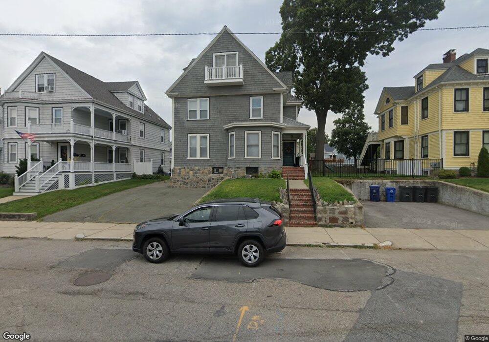
69 Minot St Dorchester, MA 02122
Neponset-Port Norfolk NeighborhoodEstimated Value: $964,000 - $1,333,000
6
Beds
3
Baths
4,695
Sq Ft
$251/Sq Ft
Est. Value
About This Home
This home is located at 69 Minot St, Dorchester, MA 02122 and is currently estimated at $1,176,748, approximately $250 per square foot. 69 Minot St is a home located in Suffolk County with nearby schools including Neighborhood House Charter School, Conservatory Lab Upper School, and St Brendan School.
Ownership History
Date
Name
Owned For
Owner Type
Purchase Details
Closed on
Nov 1, 2002
Sold by
Griffin Maureen T
Bought by
Griffin Robert A
Current Estimated Value
Home Financials for this Owner
Home Financials are based on the most recent Mortgage that was taken out on this home.
Original Mortgage
$260,000
Interest Rate
6.09%
Mortgage Type
Purchase Money Mortgage
Create a Home Valuation Report for This Property
The Home Valuation Report is an in-depth analysis detailing your home's value as well as a comparison with similar homes in the area
Home Values in the Area
Average Home Value in this Area
Purchase History
| Date | Buyer | Sale Price | Title Company |
|---|---|---|---|
| Griffin Robert A | $325,000 | -- |
Source: Public Records
Mortgage History
| Date | Status | Borrower | Loan Amount |
|---|---|---|---|
| Open | Griffin Robert A | $237,300 | |
| Closed | Griffin Robert A | $260,000 | |
| Previous Owner | Griffin Robert A | $140,000 |
Source: Public Records
Tax History Compared to Growth
Tax History
| Year | Tax Paid | Tax Assessment Tax Assessment Total Assessment is a certain percentage of the fair market value that is determined by local assessors to be the total taxable value of land and additions on the property. | Land | Improvement |
|---|---|---|---|---|
| 2025 | $12,869 | $1,111,300 | $331,300 | $780,000 |
| 2024 | $12,669 | $1,162,300 | $335,100 | $827,200 |
| 2023 | $11,671 | $1,086,700 | $313,300 | $773,400 |
| 2022 | $11,369 | $1,044,900 | $301,200 | $743,700 |
| 2021 | $10,618 | $995,100 | $286,900 | $708,200 |
| 2020 | $9,285 | $879,300 | $235,600 | $643,700 |
| 2019 | $8,582 | $814,200 | $180,000 | $634,200 |
| 2018 | $8,364 | $798,100 | $180,000 | $618,100 |
| 2017 | $7,683 | $725,500 | $180,000 | $545,500 |
| 2016 | $7,390 | $671,800 | $180,000 | $491,800 |
| 2015 | $6,349 | $524,300 | $152,100 | $372,200 |
| 2014 | $5,754 | $457,400 | $152,100 | $305,300 |
Source: Public Records
Map
Nearby Homes
- 45 Chickatawbut St Unit 1
- 43 Chickatawbut St
- 107 Minot St
- 51 Coffey St Unit 51C
- 378 Neponset Ave
- 56 Coffey St Unit 10
- 140 Minot St
- 400-412 Neponset Ave
- 701 Adams St Unit 9
- 36 Mckone St Unit 2
- 36 Mckone St
- 36 Mckone St Unit 1
- 223 Neponset Ave Unit 2
- 33 Westmoreland St
- 80 Beaumont St Unit 101
- 62 Redfield St Unit 1
- 37 Westmoreland St
- 40 Westmoreland St Unit 8
- 61 Hill Top St
- 251 Minot St Unit 6
- 71 Minot St Unit 73
- 67 Minot St
- 75 Minot St Unit 77
- 63 Minot St
- 52 Chickatawbut St
- 54 Chickatawbut St Unit 2
- 54 Chickatawbut St Unit 1
- 50 Chickatawbut St
- 46R Chickatawbut St
- 46 Chickatawbut St Unit 48
- 46 Chickatawbut St Unit 1
- 54 Chickabawbut St
- 56 Chickatawbut St
- 1 Wenlock Rd
- 76 Minot St
- 70 Minot St Unit 72
- 79 Minot St
- 79 Minot St Unit 81
- 61 Minot St
- 60 Chickatawbut St