Estimated Value: $503,000 - $597,000
4
Beds
3
Baths
2,800
Sq Ft
$194/Sq Ft
Est. Value
About This Home
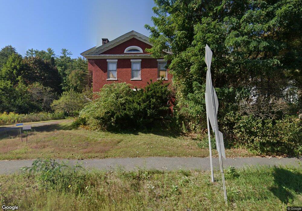
This home is located at 69 N Main Rd, Otis, MA 01253 and is currently estimated at $543,735, approximately $194 per square foot. 69 N Main Rd is a home located in Berkshire County with nearby schools including Farmington River Elementary School.
Ownership History
Date
Name
Owned For
Owner Type
Purchase Details
Closed on
May 21, 2024
Sold by
Siena James and Santibanez Katia
Bought by
Inhabitants Of The Town O
Current Estimated Value
Purchase Details
Closed on
Oct 29, 2004
Sold by
Mott Carleton H
Bought by
Siena James and Santibanez Katia
Home Financials for this Owner
Home Financials are based on the most recent Mortgage that was taken out on this home.
Original Mortgage
$240,000
Interest Rate
5.74%
Mortgage Type
Purchase Money Mortgage
Create a Home Valuation Report for This Property
The Home Valuation Report is an in-depth analysis detailing your home's value as well as a comparison with similar homes in the area
Home Values in the Area
Average Home Value in this Area
Purchase History
| Date | Buyer | Sale Price | Title Company |
|---|---|---|---|
| Inhabitants Of The Town O | -- | None Available | |
| Inhabitants Of The Town O | -- | None Available | |
| Inhabitants Of The Town O | -- | None Available | |
| Siena James | $300,000 | -- | |
| Siena James | $300,000 | -- |
Source: Public Records
Mortgage History
| Date | Status | Borrower | Loan Amount |
|---|---|---|---|
| Previous Owner | Siena James | $240,000 |
Source: Public Records
Tax History Compared to Growth
Tax History
| Year | Tax Paid | Tax Assessment Tax Assessment Total Assessment is a certain percentage of the fair market value that is determined by local assessors to be the total taxable value of land and additions on the property. | Land | Improvement |
|---|---|---|---|---|
| 2025 | $2,349 | $363,600 | $50,700 | $312,900 |
| 2024 | $2,175 | $335,600 | $52,400 | $283,200 |
| 2023 | $2,003 | $302,600 | $42,900 | $259,700 |
| 2022 | $2,226 | $319,800 | $41,100 | $278,700 |
| 2021 | $2,226 | $262,800 | $41,100 | $221,700 |
| 2020 | $2,158 | $258,800 | $41,100 | $217,700 |
| 2019 | $2,143 | $258,800 | $41,100 | $217,700 |
| 2018 | $2,143 | $258,800 | $41,100 | $217,700 |
| 2017 | $2,091 | $258,800 | $41,100 | $217,700 |
| 2016 | $2,269 | $289,000 | $41,100 | $247,900 |
| 2015 | $2,432 | $323,000 | $42,100 | $280,900 |
Source: Public Records
Map
Nearby Homes
- 32 S Main Rd
- 0 Clubhouse Dr
- 245 Clubhouse Dr
- 197 Clubhouse Dr
- 303 Lakeshore Dr
- 171 Lake Shore Dr
- 343 Lakeshore Dr
- 289 Monterey Rd
- 314 Lakeshore Dr
- 316 Lakeshore Dr
- 377 Highland Way
- 314 & 316 Lakeshore Dr
- 126 E Shore
- 309 Tamarack Trail
- 7 Perry Rd
- 40 Bliven Rd
- 232 Harrington Rd
- Lot 19-I W Center Rd
- LOT72 W Center Rd
- 340 Becket Rd
- 69 N Main Rd
- 87 N Main Rd
- 121 N Main Rd
- 13 Monterey Rd
- 7 Monterey Rd
- 4 N Main Rd
- 6 Monterey Rd
- 16E West Rd
- 12 Monterey Rd
- 27 N Main Rd
- 42 Pine Road Extention
- 11 Big Island
- 0 Norton Street Extension Unit 70510004
- 185-0-183 Pine Rd
- 0 Norton Street Extension Unit 70665198
- 2184 Monterey Rd
- 33 N Main Rd
- 32 N Main Rd
- 100 N Main Rd