Estimated Value: $121,000 - $156,000
Studio
2
Baths
1,092
Sq Ft
$127/Sq Ft
Est. Value
About This Home
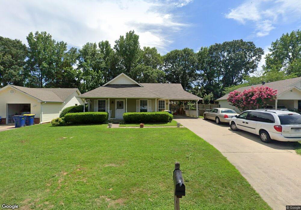
This home is located at 69 Pond St, Cabot, AR 72023 and is currently estimated at $138,865, approximately $127 per square foot. 69 Pond St is a home located in Lonoke County with nearby schools including Central Elementary School, Cabot Middle School South, and Cabot Junior High South.
Ownership History
Date
Name
Owned For
Owner Type
Purchase Details
Closed on
May 5, 2004
Bought by
Bradford
Current Estimated Value
Purchase Details
Closed on
Apr 28, 2004
Bought by
Bradford
Purchase Details
Closed on
Jun 30, 1999
Bought by
Chad Case
Purchase Details
Closed on
Nov 25, 1998
Bought by
Chad Case
Purchase Details
Closed on
Jul 15, 1996
Bought by
Felder and Wf Janice
Purchase Details
Closed on
Nov 4, 1993
Bought by
Rexanne Harbour
Purchase Details
Closed on
Oct 8, 1992
Bought by
Harbour
Purchase Details
Closed on
Jun 1, 1989
Bought by
Ziegenhagen
Purchase Details
Closed on
Mar 27, 1989
Bought by
Moore
Purchase Details
Closed on
Feb 24, 1989
Bought by
Underwood
Purchase Details
Closed on
May 18, 1988
Bought by
First State Bank
Create a Home Valuation Report for This Property
The Home Valuation Report is an in-depth analysis detailing your home's value as well as a comparison with similar homes in the area
Purchase History
| Date | Buyer | Sale Price | Title Company |
|---|---|---|---|
| Bradford | $72,000 | -- | |
| Bradford | $72,000 | -- | |
| Chad Case | -- | -- | |
| Chad Case | $64,000 | -- | |
| Felder | $65,000 | -- | |
| Rexanne Mansfield | -- | -- | |
| Rexanne Harbour | -- | -- | |
| Harbour | $51,000 | -- | |
| Ziegenhagen | $46,000 | -- | |
| Moore | -- | -- | |
| Underwood | -- | -- | |
| First State Bank | -- | -- |
Source: Public Records
Tax History
| Year | Tax Paid | Tax Assessment Tax Assessment Total Assessment is a certain percentage of the fair market value that is determined by local assessors to be the total taxable value of land and additions on the property. | Land | Improvement |
|---|---|---|---|---|
| 2025 | $733 | $14,400 | $2,000 | $12,400 |
| 2024 | $733 | $14,400 | $2,000 | $12,400 |
| 2023 | $733 | $14,400 | $2,000 | $12,400 |
| 2022 | $733 | $14,400 | $2,000 | $12,400 |
| 2021 | $733 | $14,400 | $2,000 | $12,400 |
| 2020 | $751 | $14,750 | $2,000 | $12,750 |
| 2019 | $751 | $14,750 | $2,000 | $12,750 |
| 2018 | $729 | $14,750 | $2,000 | $12,750 |
| 2017 | $677 | $14,750 | $2,000 | $12,750 |
| 2016 | $729 | $14,750 | $2,000 | $12,750 |
| 2015 | $727 | $14,710 | $2,000 | $12,710 |
| 2014 | $727 | $14,710 | $2,000 | $12,710 |
Source: Public Records
Map
Nearby Homes
- 40 Bent Tree Dr
- 34 Bent Tree Dr
- 37 Pond St
- 92 Sycamore Cir
- 57 Meadowlark Dr
- 49 Oak Meadows Dr
- 51 Meadowlark Dr
- 16 Meadowlark Dr
- 00 Plaza Blvd
- 19 Sycamore St
- 23 Robinson St
- 509 E Myrtle St
- 00 Kerr Station Rd
- 113 Walnut St
- 110 N Monroe St
- 20 Paige Ave
- 109 Pin Oak Dr
- 35 Warren St
- 28 Pheasant Run Dr
- 29 Red Oak Dr
Your Personal Tour Guide
Ask me questions while you tour the home.