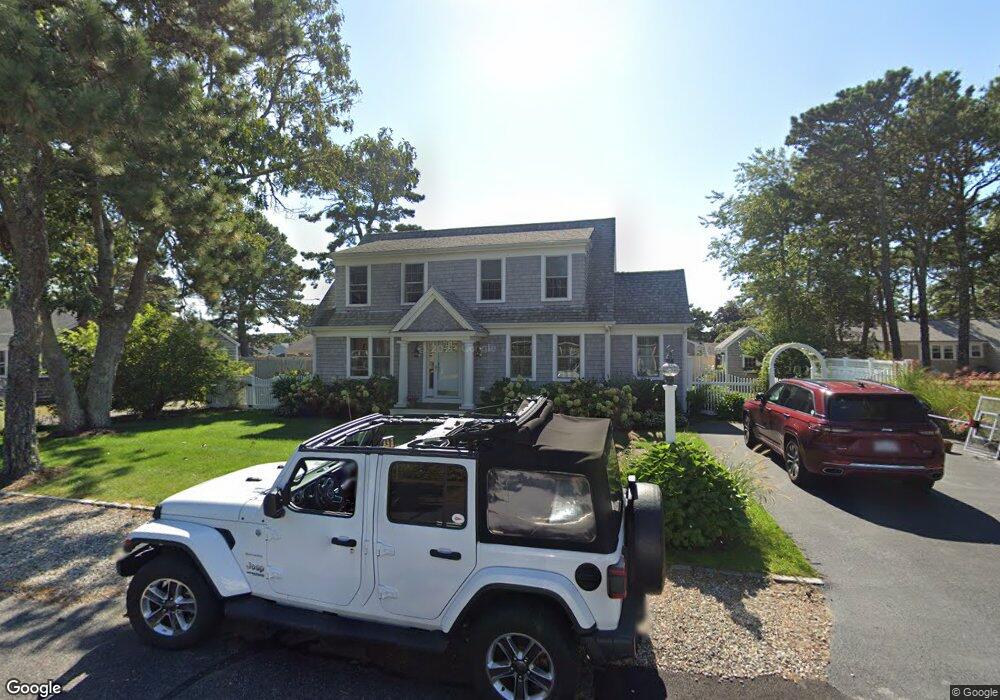
69 Santucket Rd West Dennis, MA 02670
West Dennis NeighborhoodEstimated Value: $980,000 - $1,261,000
3
Beds
3
Baths
1,760
Sq Ft
$662/Sq Ft
Est. Value
About This Home
This home is located at 69 Santucket Rd, West Dennis, MA 02670 and is currently estimated at $1,164,938, approximately $661 per square foot. 69 Santucket Rd is a home located in Barnstable County with nearby schools including Dennis-Yarmouth Regional High School.
Ownership History
Date
Name
Owned For
Owner Type
Purchase Details
Closed on
Mar 24, 1983
Bought by
Shea Michael J and Shea Mary Ellen
Current Estimated Value
Create a Home Valuation Report for This Property
The Home Valuation Report is an in-depth analysis detailing your home's value as well as a comparison with similar homes in the area
Home Values in the Area
Average Home Value in this Area
Purchase History
| Date | Buyer | Sale Price | Title Company |
|---|---|---|---|
| Shea Michael J | -- | -- |
Source: Public Records
Mortgage History
| Date | Status | Borrower | Loan Amount |
|---|---|---|---|
| Open | Shea Michael J | $198,000 | |
| Closed | Shea Michael J | $72,000 | |
| Closed | Shea Michael J | $85,000 |
Source: Public Records
Tax History Compared to Growth
Tax History
| Year | Tax Paid | Tax Assessment Tax Assessment Total Assessment is a certain percentage of the fair market value that is determined by local assessors to be the total taxable value of land and additions on the property. | Land | Improvement |
|---|---|---|---|---|
| 2025 | $4,612 | $1,065,100 | $390,000 | $675,100 |
| 2024 | $4,251 | $968,400 | $312,500 | $655,900 |
| 2023 | $4,117 | $881,500 | $284,100 | $597,400 |
| 2022 | $3,950 | $705,300 | $255,900 | $449,400 |
| 2021 | $3,869 | $641,700 | $250,900 | $390,800 |
| 2020 | $4,270 | $700,000 | $278,800 | $421,200 |
| 2019 | $3,906 | $633,100 | $273,300 | $359,800 |
| 2018 | $3,672 | $581,500 | $234,200 | $347,300 |
| 2017 | $3,576 | $581,500 | $234,200 | $347,300 |
| 2016 | $3,504 | $536,600 | $239,400 | $297,200 |
| 2015 | $3,434 | $536,600 | $239,400 | $297,200 |
| 2014 | $3,219 | $507,000 | $218,600 | $288,400 |
Source: Public Records
Map
Nearby Homes
- 40 Shore Rd
- 22 Beach View Rd
- 14 Schoolhouse Ln
- 178 School St
- 141 Main St Unit 4
- 141 Main St Unit 23
- 209 Main St Unit 5
- 209 Main St Unit 6
- 209 Main St Unit 4
- 209 Main St Unit 3
- 209 Main St Unit 2
- 209 Main St Unit 1
- 23 Doric Ave
- 401 Main St Unit 201
- 401 Main St Unit 101
- 24 Regan Rd
- 251 Old Main St
- 308 Old Main St
- 45 Seth Ln
- 181 Pleasant St