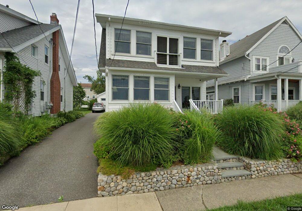
69 Seabright Ave Bridgeport, CT 06605
Black Rock NeighborhoodEstimated Value: $705,485 - $851,000
2
Beds
3
Baths
2,036
Sq Ft
$377/Sq Ft
Est. Value
About This Home
This home is located at 69 Seabright Ave, Bridgeport, CT 06605 and is currently estimated at $767,371, approximately $376 per square foot. 69 Seabright Ave is a home located in Fairfield County with nearby schools including Black Rock School, Bassick High School, and Park City Prep Charter School.
Ownership History
Date
Name
Owned For
Owner Type
Purchase Details
Closed on
Jul 5, 2024
Sold by
Broad Robert D and Wheeler Kathleen
Bought by
69 Seabright Ave Llc
Current Estimated Value
Purchase Details
Closed on
Mar 4, 2014
Sold by
Speer Richard
Bought by
Broad Robert and Wheeler Kathleen
Create a Home Valuation Report for This Property
The Home Valuation Report is an in-depth analysis detailing your home's value as well as a comparison with similar homes in the area
Home Values in the Area
Average Home Value in this Area
Purchase History
| Date | Buyer | Sale Price | Title Company |
|---|---|---|---|
| 69 Seabright Ave Llc | -- | None Available | |
| 69 Seabright Ave Llc | -- | None Available | |
| 69 Seabright Ave Llc | -- | None Available | |
| Broad Robert | $340,000 | -- | |
| Broad Robert | $340,000 | -- |
Source: Public Records
Mortgage History
| Date | Status | Borrower | Loan Amount |
|---|---|---|---|
| Previous Owner | Broad Robert | $262,000 |
Source: Public Records
Tax History Compared to Growth
Tax History
| Year | Tax Paid | Tax Assessment Tax Assessment Total Assessment is a certain percentage of the fair market value that is determined by local assessors to be the total taxable value of land and additions on the property. | Land | Improvement |
|---|---|---|---|---|
| 2025 | $13,123 | $302,014 | $181,864 | $120,150 |
| 2024 | $13,123 | $302,014 | $181,864 | $120,150 |
| 2023 | $13,123 | $302,014 | $181,864 | $120,150 |
| 2022 | $13,123 | $302,014 | $181,864 | $120,150 |
| 2021 | $13,123 | $302,014 | $181,864 | $120,150 |
| 2020 | $16,546 | $306,460 | $197,550 | $108,910 |
| 2019 | $16,546 | $306,460 | $197,550 | $108,910 |
| 2018 | $16,662 | $306,460 | $197,550 | $108,910 |
| 2017 | $16,662 | $306,460 | $197,550 | $108,910 |
| 2016 | $16,639 | $306,030 | $197,120 | $108,910 |
| 2015 | $10,647 | $252,290 | $169,710 | $82,580 |
| 2014 | $10,647 | $252,290 | $169,710 | $82,580 |
Source: Public Records
Map
Nearby Homes
- 317 Brewster St
- 75 Homestead Ave Unit 77
- 554 Brewster St Unit 4
- 26 Rowsley St Unit 3
- 39 Jetland Place Unit 41
- 37 Rowsley St Unit 6
- 105 Fox St Unit 107
- 165 Bennett St
- 166 Alfred St
- 855 Brewster St Unit 857
- 188 Monroe St Unit 190
- 167 Scofield Ave
- 0 Battery Park Dr
- 82 Waldorf Ave
- 25 Whittier St
- 31 Whittier St
- 361 Riverside Dr
- 2180 Kings Hwy Unit 1
- 130 Brentwood Ave
- 118 Berwick Ave
- 61 Seabright Ave
- 77 Seabright Ave
- 53 Seabright Ave
- 87 Seabright Ave
- 66 Beacon Ct
- 56 Beacon Ct
- 45 Seabright Ave
- 95 Seabright Ave
- 46 Beacon Ct
- 25 Seaview Terrace
- 37 Seabright Ave
- 103 Seabright Ave
- 36 Beacon Ct
- 29 Seabright Ave
- 37 Seaview Terrace
- 104 Seabright Ave
- 45 Seaview Terrace Unit 47
- 51 Seaview Terrace
- 58 Beacon Ct
- 119 Seabright Ave