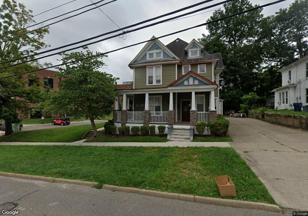
69 W State St Athens, OH 45701
Estimated Value: $422,000 - $582,000
6
Beds
3
Baths
3,639
Sq Ft
$133/Sq Ft
Est. Value
About This Home
This home is located at 69 W State St, Athens, OH 45701 and is currently estimated at $485,218, approximately $133 per square foot. 69 W State St is a home located in Athens County with nearby schools including West Elementary School, Athens Middle School, and Athens High School.
Ownership History
Date
Name
Owned For
Owner Type
Purchase Details
Closed on
Sep 20, 2019
Sold by
Wharton John A
Bought by
Wharton John A and Wharton Joyce
Current Estimated Value
Purchase Details
Closed on
Sep 3, 2019
Sold by
Davis Davis Ralph S Ralph S and Davis Ralph S
Bought by
Wharton John A
Purchase Details
Closed on
May 26, 2017
Sold by
Wharton John A
Bought by
Hocking Valley Bank
Purchase Details
Closed on
May 12, 2017
Sold by
Miller Thomas
Bought by
Davis Ralph S and Davis Ellen F
Purchase Details
Closed on
Dec 29, 1997
Sold by
Davis Ralph S
Bought by
Davis Ralph
Purchase Details
Closed on
Jul 22, 1994
Sold by
Oliveri Dante N
Bought by
Davis Ralph S
Purchase Details
Closed on
Apr 1, 1991
Create a Home Valuation Report for This Property
The Home Valuation Report is an in-depth analysis detailing your home's value as well as a comparison with similar homes in the area
Home Values in the Area
Average Home Value in this Area
Purchase History
| Date | Buyer | Sale Price | Title Company |
|---|---|---|---|
| Wharton John A | -- | None Available | |
| Wharton John A | $373,000 | None Available | |
| Hocking Valley Bank | -- | None Available | |
| Davis Ralph S | -- | None Available | |
| Davis Ralph | -- | -- | |
| Davis Ralph S | -- | -- | |
| -- | $25,000 | -- |
Source: Public Records
Tax History Compared to Growth
Tax History
| Year | Tax Paid | Tax Assessment Tax Assessment Total Assessment is a certain percentage of the fair market value that is determined by local assessors to be the total taxable value of land and additions on the property. | Land | Improvement |
|---|---|---|---|---|
| 2024 | $7,678 | $142,780 | $7,280 | $135,500 |
| 2023 | $4,227 | $142,780 | $7,280 | $135,500 |
| 2022 | $5,987 | $113,140 | $7,280 | $105,860 |
| 2021 | $6,013 | $113,140 | $7,280 | $105,860 |
| 2020 | $3,504 | $113,140 | $7,280 | $105,860 |
| 2019 | $3,504 | $67,060 | $6,130 | $60,930 |
| 2018 | $3,460 | $67,060 | $6,130 | $60,930 |
| 2017 | $5,972 | $67,060 | $6,130 | $60,930 |
| 2016 | $2,980 | $59,690 | $5,830 | $53,860 |
| 2015 | $5,452 | $59,690 | $5,830 | $53,860 |
| 2014 | $5,452 | $59,690 | $5,830 | $53,860 |
| 2013 | $5,171 | $58,190 | $5,830 | $52,360 |
Source: Public Records
Map
Nearby Homes
- 71 W Washington St
- 80 Court
- 12 Walker St
- 11 Walker St
- 31 1st St
- 0 Roberts St
- 7 Elizabeth Dr
- 214 W State St
- 10 1st St
- 64 Franklin Ave
- 17 Ring St
- 193 N Lancaster St
- 56.15/15.5 Central & Clark
- 15 S Shafer St Unit 1509
- 131 Grosvenor St
- 98 Central Ave
- 18 Clarke St
- 273 E State St
- 8181 Dairy Ln
- 550 W Union St
- 73 W State St
- 13 S Lancaster St
- 75 W State St
- 2 Lancaster
- 72 W State St
- 77 W State St
- 70 W State St
- 74 W State St
- 85 W State St
- 17 S Lancaster St
- 8 N Lancaster St
- 19 S Lancaster St
- 52 W State St
- 80 W State St
- 54 W State St
- 11 N Lancaster St
- 10 N Lancaster St
- 82 W State St
- 21 S Lancaster St
- 13 N Lancaster St