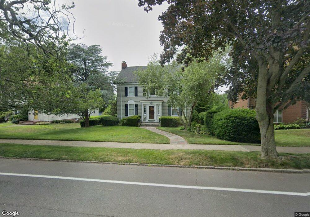
690 Townsend Ave New Haven, CT 06512
East Shore NeighborhoodEstimated Value: $462,299 - $806,000
4
Beds
2
Baths
2,322
Sq Ft
$270/Sq Ft
Est. Value
About This Home
This home is located at 690 Townsend Ave, New Haven, CT 06512 and is currently estimated at $626,575, approximately $269 per square foot. 690 Townsend Ave is a home located in New Haven County with nearby schools including Nathan Hale School, Cold Spring School, and All Saints Catholic Academy.
Ownership History
Date
Name
Owned For
Owner Type
Purchase Details
Closed on
Aug 9, 1993
Sold by
Heath Jeffrey T and Russo Eugene J
Bought by
Smith Thomas R and Reiber David M
Current Estimated Value
Home Financials for this Owner
Home Financials are based on the most recent Mortgage that was taken out on this home.
Original Mortgage
$131,000
Interest Rate
4.13%
Mortgage Type
Unknown
Purchase Details
Closed on
Jun 5, 1987
Sold by
Smith Thomas R
Bought by
Heath Jeffrey T
Home Financials for this Owner
Home Financials are based on the most recent Mortgage that was taken out on this home.
Original Mortgage
$90,000
Interest Rate
10.38%
Create a Home Valuation Report for This Property
The Home Valuation Report is an in-depth analysis detailing your home's value as well as a comparison with similar homes in the area
Home Values in the Area
Average Home Value in this Area
Purchase History
| Date | Buyer | Sale Price | Title Company |
|---|---|---|---|
| Smith Thomas R | $217,500 | -- | |
| Heath Jeffrey T | $250,000 | -- |
Source: Public Records
Mortgage History
| Date | Status | Borrower | Loan Amount |
|---|---|---|---|
| Closed | Heath Jeffrey T | $124,000 | |
| Closed | Heath Jeffrey T | $131,000 | |
| Previous Owner | Heath Jeffrey T | $125,100 | |
| Previous Owner | Heath Jeffrey T | $90,000 |
Source: Public Records
Tax History
| Year | Tax Paid | Tax Assessment Tax Assessment Total Assessment is a certain percentage of the fair market value that is determined by local assessors to be the total taxable value of land and additions on the property. | Land | Improvement |
|---|---|---|---|---|
| 2025 | $10,354 | $262,780 | $66,850 | $195,930 |
| 2024 | $10,117 | $262,780 | $66,850 | $195,930 |
| 2023 | $9,775 | $262,780 | $66,850 | $195,930 |
| 2022 | $10,446 | $262,780 | $66,850 | $195,930 |
| 2021 | $8,588 | $195,720 | $41,790 | $153,930 |
| 2020 | $8,588 | $195,720 | $41,790 | $153,930 |
| 2019 | $8,412 | $195,720 | $41,790 | $153,930 |
| 2018 | $8,412 | $195,720 | $41,790 | $153,930 |
| 2017 | $7,570 | $195,720 | $41,790 | $153,930 |
| 2016 | $7,981 | $192,080 | $43,470 | $148,610 |
| 2015 | $7,981 | $192,080 | $43,470 | $148,610 |
| 2014 | $7,981 | $192,080 | $43,470 | $148,610 |
Source: Public Records
Map
Nearby Homes
- 197 Kneeland Rd
- 745 Townsend Ave Unit Lot 7
- 745 Townsend Ave Unit Lot 1
- 145 Fort Hale Rd
- 253 Kneeland Rd
- 105 Sound View Terrace
- 675 Townsend Ave Unit 157
- 418 Woodward Ave Unit 9
- 366 Burr St
- 120 Stuyvesant Ave
- 88 Elizabeth Ann Dr
- 388 Concord St
- 21 Carmen St
- 19 Hughes St
- 9 Forest St
- 327 Concord St
- 44 Huntington Ave
- 102 Forest Street Extension
- 31 Forest St
- 45 Huntington Ave
- 680 Townsend Ave
- 694 Townsend Ave
- 672 Townsend Ave
- 700 Townsend Ave
- 55 Raynham Rd
- 113 Kneeland Rd
- 119 Kneeland Rd
- 664 Townsend Ave
- 107 Kneeland Rd
- 101 Kneeland Rd
- 125 Kneeland Rd
- 95 Kneeland Rd
- 656 Townsend Ave
- 131 Kneeland Rd
- 91 Kneeland Rd
- 663 Townsend Ave
- 665 Townsend Ave
- 709 Townsend Ave
- 650 Townsend Ave
- 720 Townsend Ave
Your Personal Tour Guide
Ask me questions while you tour the home.