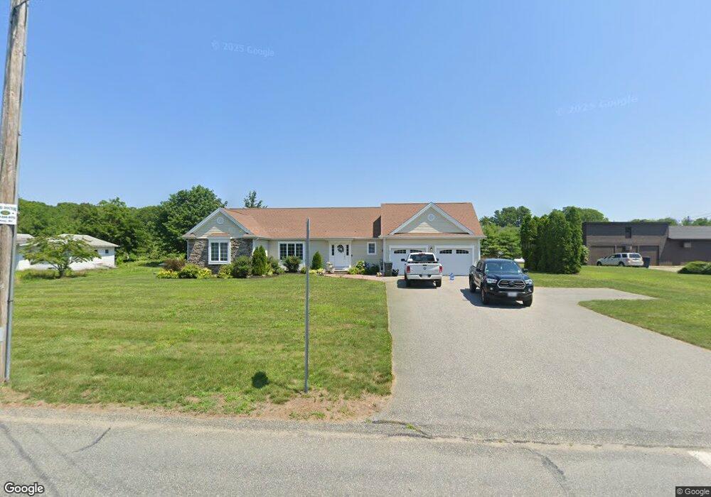
690 Warren Ave Swansea, MA 02777
Monroes-South Seekonk NeighborhoodEstimated Value: $496,000 - $602,000
2
Beds
2
Baths
1,444
Sq Ft
$379/Sq Ft
Est. Value
About This Home
This home is located at 690 Warren Ave, Swansea, MA 02777 and is currently estimated at $547,896, approximately $379 per square foot. 690 Warren Ave is a home located in Bristol County with nearby schools including Joseph Case High School, Barrington Christian Academy, and St. Andrews School.
Ownership History
Date
Name
Owned For
Owner Type
Purchase Details
Closed on
Dec 12, 2023
Sold by
Darling Lois A
Bought by
690 Warren Ave Llc
Current Estimated Value
Purchase Details
Closed on
Dec 31, 2013
Sold by
Darling Development Co
Bought by
Darling Lois A
Purchase Details
Closed on
Dec 13, 2012
Sold by
Darling Dev Corp
Bought by
Darling Lois A
Create a Home Valuation Report for This Property
The Home Valuation Report is an in-depth analysis detailing your home's value as well as a comparison with similar homes in the area
Home Values in the Area
Average Home Value in this Area
Purchase History
| Date | Buyer | Sale Price | Title Company |
|---|---|---|---|
| 690 Warren Ave Llc | -- | None Available | |
| Darling Lois A | -- | -- | |
| Darling Lois A | -- | -- |
Source: Public Records
Tax History Compared to Growth
Tax History
| Year | Tax Paid | Tax Assessment Tax Assessment Total Assessment is a certain percentage of the fair market value that is determined by local assessors to be the total taxable value of land and additions on the property. | Land | Improvement |
|---|---|---|---|---|
| 2025 | $6,365 | $534,000 | $176,000 | $358,000 |
| 2024 | $6,343 | $529,000 | $176,000 | $353,000 |
| 2023 | $6,126 | $466,600 | $128,700 | $337,900 |
| 2022 | $6,057 | $420,900 | $117,000 | $303,900 |
| 2021 | $5,553 | $355,300 | $117,000 | $238,300 |
| 2020 | $5,536 | $355,300 | $117,000 | $238,300 |
| 2019 | $5,315 | $342,700 | $104,400 | $238,300 |
| 2018 | $6,888 | $450,800 | $106,500 | $344,300 |
| 2017 | $5,987 | $450,800 | $106,500 | $344,300 |
| 2016 | $5,953 | $440,300 | $94,900 | $345,400 |
| 2015 | $5,337 | $406,500 | $94,900 | $311,600 |
| 2014 | $5,272 | $410,600 | $94,900 | $315,700 |
Source: Public Records
Map
Nearby Homes
- 15 George w Finnerty Rd
- 7 Cheshire Dr
- 5 George St
- 4 Old Chimney Rd
- 7 Wright Place
- 3 Pine Top Rd
- 15 Lamson Rd
- 19 Evergreen St
- 7 Jill Ct
- 7 Simmons Rd
- 23 Pine Top Rd
- 72 School St
- 1261 Grand Army of the Republic Hwy
- 6 Plymouth Dr
- 15 Stanhope Dr
- 3 Kenmore Ct
- 6 Kenmore Ct
- 20 Burr Ave
- 43 Baptist St
- 6 Hazelton Rd
- 680 Warren Ave
- 702 Warren Ave
- 4 New Meadow Rd
- 0 E S New Meadow Rd Unit 71751019
- 0 E S New Meadow Rd Unit 1080214
- 135 Palmer River Rd
- 699 Warren Ave
- 1 New Meadow Rd
- 3 New Meadow Rd
- 121 Palmer River Rd
- 683 Warren Ave
- 711 Warren Ave
- 154 New Meadow Rd
- 151 Palmer River Rd
- Lot 21 Palmer River Rd
- 736 Warren Ave
- 671 Warren Ave
- 719 Warren Ave
- 134 New Meadow Rd
- 152 Palmer River Way