NOT LISTED FOR SALE

6901 Greenbranch Ln Unit 1 Cedar Rapids, IA 52411

Estimated Value: $622,000 - $901,000

29 Acres
$27,886 Price per Acre
1,253,221 Sq Ft Lot

Last Sold November 24, 2014

Last sale price $1,250,000

Est. 36% decrease in value since last sale

Current estimated payment $5,220/month

385 Days on Market

Highlights

  • 28.77 Acre Lot
  • Wooded Lot
  • Machine Shed
  • John F. Kennedy High School Rated A-
  • Pole Barn
  • Level Lot

About This Lot

As of November 2014

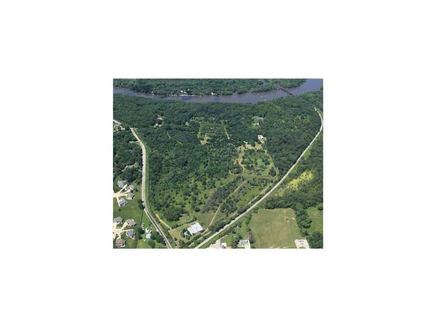
Qualified buyers only, financing shall be fulfilled within 60 days of offer. All personal property shall remain on the property of seller. In the event buyer wants to purchase personal property it will be done so at the consideration of the seller and will be in addition to the sale price of the real estate. Zoning/annexation shall be the responsibility of the buyers. Fabulous development property just west of Xavier High School. Heavily treed with bluffs overlooking the Cedar River. Perfect for upscale housing or magnificent setting for executive retreat. SOLD WITH MLS #1306357.

Last Agent to Sell the Property

Scott Carnes

SKOGMAN REALTY COMMERCIAL Listed on: 09/10/2013

Co-Listed By

Terry Knake

SKOGMAN REALTY COMMERCIAL

Last Buyer's Agent

Jason Vestweber

SKOGMAN REALTY

SKOGMAN REALTY

Property Details

Property Type

  • Land

Est. Annual Taxes

  • $309

Year Built

  • 2019

Lot Details

  • 28.77 Acre Lot
  • Fence is in good condition
  • Level Lot
  • Wooded Lot

Utilities

  • Propane
  • Well

Additional Features

  • Pole Barn
  • Machine Shed

Property Details

Property Type

Land

Est. Annual Taxes

$309

Year Built

2019

Lot Details

0

Listing Details

  • Acres: 28.7700
  • City Name: Cedar Rapids
  • Current Zoning: AG
  • Gross Tax: 309
  • List User Cell Phone: 319-551-0673
  • Miscellaneous: Easements, Fences-Good, Mach Shed, No Fence, Pole Barn
  • Net Tax: 302
  • Property Sub Types: Development Land
  • Property Type: Land/Lot/Farm
  • Ratio Close Price By List Price: 1.67108
  • Ratio Close Price By Original Li: 2.15785
  • Tax Roll Number: 130137600400000
  • Water Sewer Roads: Well Water, Paved
  • Special Features: None
  • Property Sub Type: LotsLands
  • Year Built (Public Record): 2019

Interior Features

  • Site Description: Gentle Roll, Level, Wooded

Utilities

  • Utilities: Electric, Lp
  • Sewer: Septic

Schools

  • Elementary School: Pierce
  • Middle School: Harding
  • High School: Kennedy

Lot Info

  • Lot Size: 28.77 ACR

Ownership History

Date Name Owned For Owner Type

Purchase Details

Closed on
Feb 24, 2016
Sold by
Johnson Michael T and Johnson Tamara L
Bought by
Johnson Brandon L and Johnson Sarah L
Total Days on Market
385
Current Estimated Value
$802,267

Home Financials for this Owner

Home Financials are based on the most recent Mortgage that was taken out on this home.
Original Mortgage
$130,000
Interest Rate
3.68%
Mortgage Type
Stand Alone Refi Refinance Of Original Loan

Purchase Details

Closed on
Feb 22, 2016
Sold by
Boyer Barry J and Boyer Gilda L
Bought by
Johnson Michael T and Johnson Tamara L

Home Financials for this Owner

Home Financials are based on the most recent Mortgage that was taken out on this home.
Original Mortgage
$130,000
Interest Rate
3.68%
Mortgage Type
Stand Alone Refi Refinance Of Original Loan

Purchase Details

Listed on
Sep 10, 2013
Closed on
Nov 23, 2014
Sold by
Evanow James M and Evanow Lynn D
Bought by
Johnson Michael T and Johnson Tamera L
Seller's Agent
Scott Carnes
SKOGMAN REALTY COMMERCIAL
Buyer's Agent
Jason Vestweber
SKOGMAN REALTY
List Price
$579,280
Sold Price
$1,250,000
Premium/Discount to List
$670,720
115.79%

Home Financials for this Owner

Home Financials are based on the most recent Mortgage that was taken out on this home.
Avg. Annual Appreciation
-4.12%
Source: Public Records

Similar Property in Cedar Rapids, IA

  • 0 Milburn Rd, Cedar Rapids, IA 52411

    $730,000

    • Land
    • 29 Acres
    • $24,949 per Acre
    • 0 Milburn Rd
    • Cedar Rapids, IA

    This 29.26 acre parcel is ideally located in the high-demand residential area between Blairs Ferry Rd and Tower Terrace Rd. Currently zoned as agricultural land, it is within city limits and the Cedar Rapids, Viola Gibson, and Kennedy school districts. This parcel is ideal for development.

    Karen Mathison COLDWELL BANKER HEDGES

    Section Image

Range of Values:

Collateral Analytics

Collateral Analytics Collateral Analytics AVMs (Automated Valuation Model) employ a number of statistical approaches combined with neighborhood-specific comparable selection guarantees the most up-to-date and precise valuations.

Not Available

Collateral Analytics does not have data for the current month. Please view the chart for historical values.

ICE

ICE Mortgage Technology ICE Mortgage Technology’s AVM (Automated Valuation Model) is a state-of-the-art online residential property valuation tool that provides a quick and accurate estimate of the value of almost any home in the U.S.

Not Available

ICE Mortgage Technology does not have data for the current month. Please view the chart for historical values.

First American

First American First American Data & Analytics’ next-generation AVM combines unrivaled data assets with a blended ensemble of valuation models to produce highly accurate, reliable valuations you can trust.

Not Available

First American does not have data for the current month. Please view the chart for historical values.

Quantarium

Quantarium Quantarium’s valuation service, repeatedly proven the industry’s most accurate and comprehensive, is supercharged with a self-learning and auto-tuning AI engine that continually becomes smarter and more accurate as it processes daily inputs from the industry’s leading RE data lake.

Not Available

Quantarium does not have data for the current month. Please view the chart for historical values.

Average Value
Not Available
List Price
Sold Price
Create a Home Valuation Report for This Property
The Home Valuation Report is an in-depth analysis detailing your home's value as well as a comparison with similar homes in the area

Home Values in the Area

Source: Public Records

Average Home Value in this Area


Source: Public Records

Purchase History

Date Buyer Sale Price Title Company
Johnson Brandon L -- None Available
Johnson Michael T -- None Available
Source: Public Records

Mortgage History

Date Status Borrower Loan Amount
Open Johnson Brandon L $484,350
Closed Johnson Brandon L $137,900
Closed Johnson Brandon L $484,350
Closed Johnson Brandon L $137,900
Closed Johnson Brandon L $589,500
Closed Johnson Brandon L $60,000
Closed Johnson Brandon L $130,000
Source: Public Records

Property History

Date Event Price Change Sq Ft Price
11/24/2014 11/24/14 Sold $1,250,000 +66.8% --
09/30/2014 09/30/14 Pending -- -- --
10/17/2013 10/17/13 Sold $749,200 +29.3% --
09/10/2013 09/10/13 For Sale $579,280 -81.5% --
09/04/2013 09/04/13 Pending -- -- --
06/24/2010 06/24/10 For Sale $3,139,390 -- --
Source: Cedar Rapids Area Association of REALTORS®

Tax History Compared to Growth

Source: Public Records

Tax History

Year Tax Paid Tax Assessment Tax Assessment Total Assessment is a certain percentage of the fair market value that is determined by local assessors to be the total taxable value of land and additions on the property. Land Improvement
2023 $8,854 $766,100 $78,000 $688,100
2022 $8,750 $626,500 $78,000 $548,500
2021 $11,290 $626,500 $78,000 $548,500
2020 $11,290 $165,700 $55,000 $110,700
2019 $2,368 $160,100 $55,000 $105,100
2018 $2,318 $160,100 $55,000 $105,100
2017 $0 $101,500 $900 $100,600
2016 $0 $0 $0 $0
Source: Public Records

Agents Affiliated with this Home

  • Section Image
  • Section Image
  • Section Image
See All Agents

Map

Source: Cedar Rapids Area Association of REALTORS®

MLS Number: 1306354

Cedar Rapids Area Association of REALTORS®

APN: 13013-51004-00000