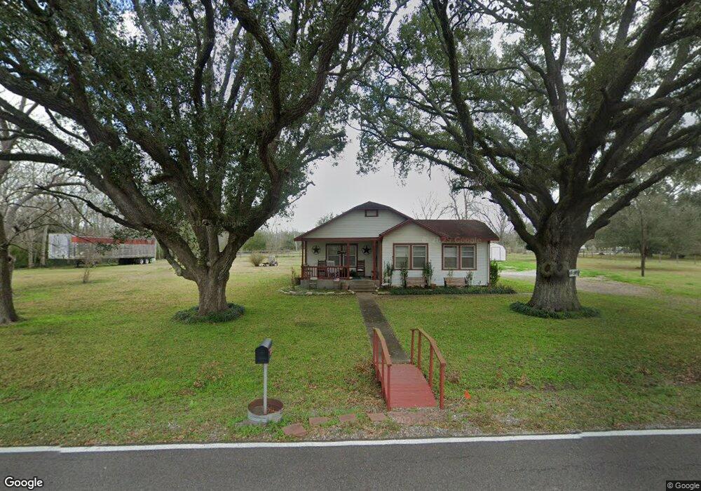
6902 Cemetary Rd Manvel, TX 77578
Estimated Value: $367,000 - $493,000
--
Bed
1
Bath
1,396
Sq Ft
$319/Sq Ft
Est. Value
About This Home
This home is located at 6902 Cemetary Rd, Manvel, TX 77578 and is currently estimated at $445,611, approximately $319 per square foot. 6902 Cemetary Rd is a home located in Brazoria County with nearby schools including E.C. Mason Elementary School and Manvel High School.
Ownership History
Date
Name
Owned For
Owner Type
Purchase Details
Closed on
Feb 4, 2025
Sold by
Smith Ivan Eugene and Smith Linda Kate
Bought by
Motter George F and Motter Michele D
Current Estimated Value
Purchase Details
Closed on
Jun 10, 1998
Sold by
Maloney Joe Dean
Bought by
Maloney Bessie Marie
Home Financials for this Owner
Home Financials are based on the most recent Mortgage that was taken out on this home.
Original Mortgage
$60,000
Interest Rate
7.08%
Create a Home Valuation Report for This Property
The Home Valuation Report is an in-depth analysis detailing your home's value as well as a comparison with similar homes in the area
Home Values in the Area
Average Home Value in this Area
Purchase History
| Date | Buyer | Sale Price | Title Company |
|---|---|---|---|
| Motter George F | -- | Envision Title | |
| Maloney Bessie Marie | -- | -- |
Source: Public Records
Mortgage History
| Date | Status | Borrower | Loan Amount |
|---|---|---|---|
| Previous Owner | Maloney Bessie Marie | $60,000 |
Source: Public Records
Tax History Compared to Growth
Tax History
| Year | Tax Paid | Tax Assessment Tax Assessment Total Assessment is a certain percentage of the fair market value that is determined by local assessors to be the total taxable value of land and additions on the property. | Land | Improvement |
|---|---|---|---|---|
| 2025 | $2,520 | $344,729 | $419,900 | $114,630 |
| 2023 | $2,520 | $284,900 | $419,900 | $115,450 |
| 2022 | $7,503 | $259,000 | $195,230 | $63,770 |
| 2021 | $7,193 | $254,250 | $181,290 | $72,960 |
| 2020 | $7,014 | $254,250 | $181,290 | $72,960 |
| 2019 | $6,633 | $220,740 | $153,400 | $67,340 |
| 2018 | $8,391 | $299,840 | $216,500 | $83,340 |
| 2017 | $7,703 | $306,790 | $225,910 | $80,880 |
| 2016 | $7,002 | $275,060 | $188,260 | $86,800 |
| 2014 | $3,499 | $222,270 | $139,450 | $82,820 |
Source: Public Records
Map
Nearby Homes
- 0 Lewis Ln
- 5035 Prairie Gourd Meadow
- 5102 Pomegranate Path
- 6655 Cemetery Rd
- 20503 Morris Ave
- TBD Morris Ave
- 7146 Masters Rd
- 7431 Rodgers Rd
- 7643 Dalmolin Rd
- 21219 Horse Shoe Dr
- 7142 Lewis Ln
- 21214 Creek Rd
- 21103 Highway 6
- 00 Palmetto St
- 7315 Pine St
- 1 Wolfe Ln
- 0 Hwy 6 Unit 51687667
- 0 Highway 6 Unit 58858783
- 0 Hwy 6 Unit 16748126
- 10219 Botticelli Path
- 6820 Cemetary Rd
- 7514 Flora Rd
- 6819 Cemetary Rd
- 6911 Cemetary Rd
- 7520 Flora Rd
- 7512 Flora Rd
- 6811 Cemetary Rd
- 6919 Cemetary Rd
- 6927 Cemetery Rd
- 6927 Cemetary Rd
- 6702 Crestridge St
- 7510 Flora Rd
- 6910 Alabama St
- 6750 Cemetary Rd Unit 96
- 20611 Georgia St
- 6942 Cemetary Rd
- 6942 Cemetery Rd Unit B
- 6942 Cemetery Rd Unit A
- 6755 Cemetary Rd Unit 96
- 6918 Alabama St