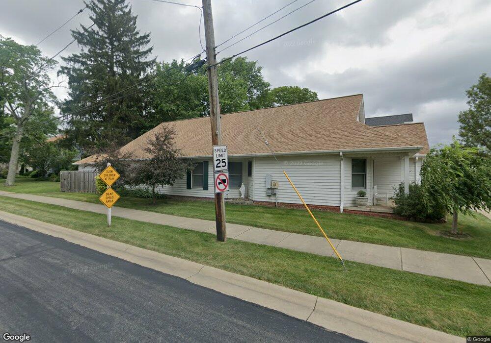
6903 Chestnut Rd Independence, OH 44131
Estimated Value: $289,132 - $396,000
3
Beds
2
Baths
1,721
Sq Ft
$197/Sq Ft
Est. Value
About This Home
This home is located at 6903 Chestnut Rd, Independence, OH 44131 and is currently estimated at $339,033, approximately $196 per square foot. 6903 Chestnut Rd is a home located in Cuyahoga County with nearby schools including Independence Primary School, Independence Middle School, and Independence High School.
Ownership History
Date
Name
Owned For
Owner Type
Purchase Details
Closed on
Sep 28, 2015
Sold by
Kurtz Laura and Zurowski Dale
Bought by
Zurowski Dale
Current Estimated Value
Purchase Details
Closed on
May 26, 2004
Sold by
Zurowski Edward J and Zurowski Irene D
Bought by
Kurtz Laura and Zurowski Dale
Purchase Details
Closed on
Aug 10, 1995
Sold by
F J J Ltd Liability Co
Bought by
Zurowski Edward J and Zurowski Irene D
Purchase Details
Closed on
Nov 18, 1994
Sold by
Kendall Jean B
Bought by
F J J Ltd Liability Co
Purchase Details
Closed on
Jan 1, 1975
Bought by
Kendall Percy R and Jean Booth
Create a Home Valuation Report for This Property
The Home Valuation Report is an in-depth analysis detailing your home's value as well as a comparison with similar homes in the area
Home Values in the Area
Average Home Value in this Area
Purchase History
| Date | Buyer | Sale Price | Title Company |
|---|---|---|---|
| Zurowski Dale | $99,200 | Attorney | |
| Kurtz Laura | -- | -- | |
| Zurowski Edward J | $35,000 | -- | |
| F J J Ltd Liability Co | $200,000 | -- | |
| Kendall Percy R | -- | -- |
Source: Public Records
Tax History
| Year | Tax Paid | Tax Assessment Tax Assessment Total Assessment is a certain percentage of the fair market value that is determined by local assessors to be the total taxable value of land and additions on the property. | Land | Improvement |
|---|---|---|---|---|
| 2024 | $4,716 | $98,595 | $12,740 | $85,855 |
| 2023 | $4,618 | $87,750 | $11,940 | $75,810 |
| 2022 | $4,593 | $87,750 | $11,940 | $75,810 |
| 2021 | $4,526 | $87,750 | $11,940 | $75,810 |
| 2020 | $4,426 | $80,500 | $10,960 | $69,550 |
| 2019 | $4,272 | $230,000 | $31,300 | $198,700 |
| 2018 | $4,094 | $80,500 | $10,960 | $69,550 |
| 2017 | $3,859 | $69,450 | $8,230 | $61,220 |
| 2016 | $3,820 | $69,450 | $8,230 | $61,220 |
| 2015 | $3,914 | $69,450 | $8,230 | $61,220 |
| 2014 | $3,914 | $69,450 | $8,230 | $61,220 |
Source: Public Records
Map
Nearby Homes
- 0 Brecksville Rd
- 0 Daisy Blvd
- 8420 Stone Rd
- 0 Acorn Dr Unit 5023848
- 6990 S Great Oaks Pkwy
- VL Laura Lee Ln
- VL TBB Laura Lee Ln
- 9800 Gleeson Dr
- 6473 Tanglewood Ln
- 5706 Heinton Rd
- 7003 Brecksville Rd
- 6312 E Pleasant Valley Rd
- 7477 Ludwin Dr
- 1026 Joy Oval
- 9152 Fosdick Rd
- 6258 Carlyle Dr
- 3347 Jasmine Dr
- 5860 N Crossview Rd
- 1329 E Schaaf Rd
- 5770 N Crossview Rd
- 6905 Chestnut Rd
- 6511 Anderson Ave
- 6907 Chestnut Rd
- 6520 Anderson Ave
- 6507 Anderson Ave
- 6911 Chestnut Rd
- 6516 Anderson Ave
- 6915 Chestnut Rd
- 6501 Anderson Ave
- 6508 Anderson Ave
- 6710 Chestnut Rd
- 6615 Chestnut Rd
- 6500 Anderson Ave
- 6706 Chestnut Rd
- 6816 Daisy Ave
- 6812 Daisy Ave
- V/L Daisy Ave
- 6718 Daisy Ave
- 6611 Chestnut Rd
Your Personal Tour Guide
Ask me questions while you tour the home.