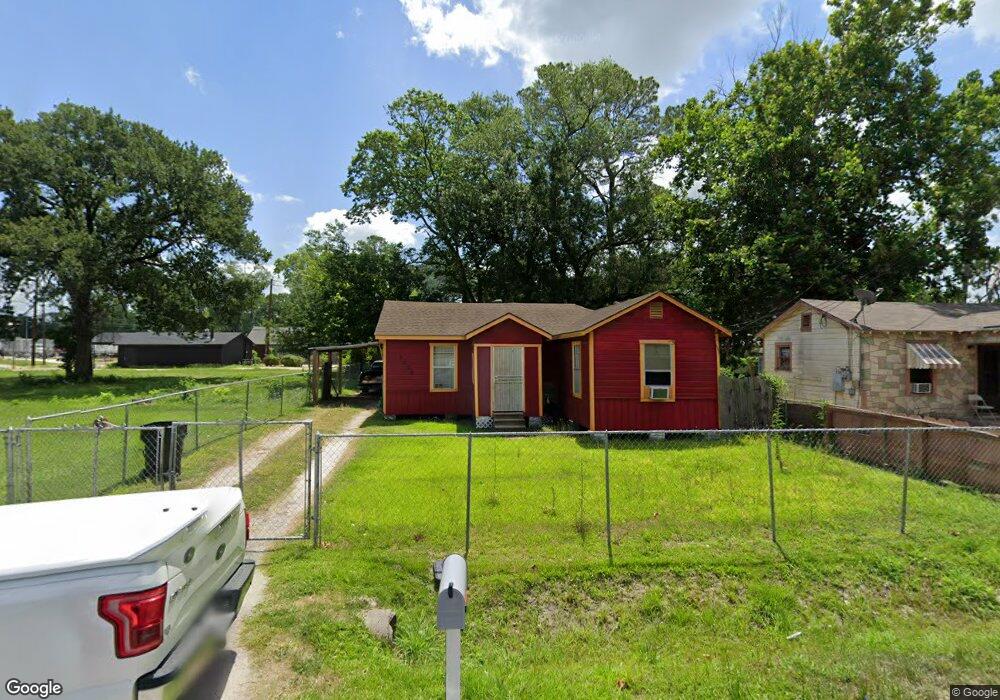
6906 Bethune Dr Houston, TX 77091
Acres Homes NeighborhoodEstimated Value: $160,000 - $192,000
3
Beds
2
Baths
1,191
Sq Ft
$147/Sq Ft
Est. Value
About This Home
This home is located at 6906 Bethune Dr, Houston, TX 77091 and is currently estimated at $174,528, approximately $146 per square foot. 6906 Bethune Dr is a home located in Harris County with nearby schools including Reece Academy, Anderson Academy, and Drew Academy.
Ownership History
Date
Name
Owned For
Owner Type
Purchase Details
Closed on
Oct 26, 2004
Sold by
First Capital Interest Llc
Bought by
Williams Hazel
Current Estimated Value
Home Financials for this Owner
Home Financials are based on the most recent Mortgage that was taken out on this home.
Original Mortgage
$21,900
Interest Rate
5.74%
Mortgage Type
Seller Take Back
Purchase Details
Closed on
Jun 9, 1999
Sold by
Hilal Danny
Bought by
First Capital Interest Llc
Create a Home Valuation Report for This Property
The Home Valuation Report is an in-depth analysis detailing your home's value as well as a comparison with similar homes in the area
Home Values in the Area
Average Home Value in this Area
Purchase History
| Date | Buyer | Sale Price | Title Company |
|---|---|---|---|
| Williams Hazel | -- | -- | |
| First Capital Interest Llc | -- | -- |
Source: Public Records
Mortgage History
| Date | Status | Borrower | Loan Amount |
|---|---|---|---|
| Previous Owner | Williams Hazel | $21,900 |
Source: Public Records
Tax History Compared to Growth
Tax History
| Year | Tax Paid | Tax Assessment Tax Assessment Total Assessment is a certain percentage of the fair market value that is determined by local assessors to be the total taxable value of land and additions on the property. | Land | Improvement |
|---|---|---|---|---|
| 2025 | $2,758 | $123,000 | $60,207 | $62,793 |
| 2024 | $2,758 | $121,511 | $58,500 | $63,011 |
| 2023 | $2,758 | $101,493 | $54,600 | $46,893 |
| 2022 | $2,280 | $95,040 | $50,000 | $45,040 |
| 2021 | $1,666 | $66,337 | $27,500 | $38,837 |
| 2020 | $1,849 | $70,057 | $27,500 | $42,557 |
| 2019 | $1,627 | $58,807 | $16,250 | $42,557 |
| 2018 | $758 | $52,813 | $7,500 | $45,313 |
| 2017 | $1,046 | $52,813 | $7,500 | $45,313 |
| 2016 | $951 | $52,813 | $7,500 | $45,313 |
| 2015 | $727 | $32,584 | $7,500 | $25,084 |
| 2014 | $727 | $32,584 | $7,500 | $25,084 |
Source: Public Records
Map
Nearby Homes
- 6906 Mcwilliams Dr
- 6814 Covington Dr
- 6701 Bunche Dr
- 6706 Greenhurst St
- 6621 Greenhurst St
- 6626 Ezzard Charles Ln
- 6721 Cathcart Dr
- 6547 Mcwilliams Dr
- 6605 Greenhurst St
- 6609 Ezzard Charles Ln
- 0 W Little York Rd Unit 9657551
- 0 W Little York Rd Unit 14583802
- 0 W Little York Rd Unit 88983753
- 2415 W Little York Rd Unit D
- 7315 Parkes St
- 0 Cliffdale St
- 0 Dyer St
- 2212 Wilburforce St
- 6514 Old Olive Tree Dr
- 6515 Old Olive Tree Dr
- 6902 Bethune Dr
- 6905 Mcwilliams Dr
- 6830 Bethune Dr
- 6901 Mcwilliams Dr
- 6722 Bethune Dr
- 6827 Mcwilliams Dr
- 6827 Mcwilliams Dr Unit A
- 6826 Bethune Dr
- 6901 Bethune Dr
- 6909 Bethune Dr
- 0 Bethune Dr
- 6825 Mcwilliams Dr
- 6827 Bethune Dr
- 2507 W Little York Rd
- 2027 W Little York Rd
- 6822 Bethune Dr
- 6821 Mcwilliams Dr
- 6910 Mcwilliams Dr
- 6818 Bethune Dr
- 6902 Mcwilliams Dr