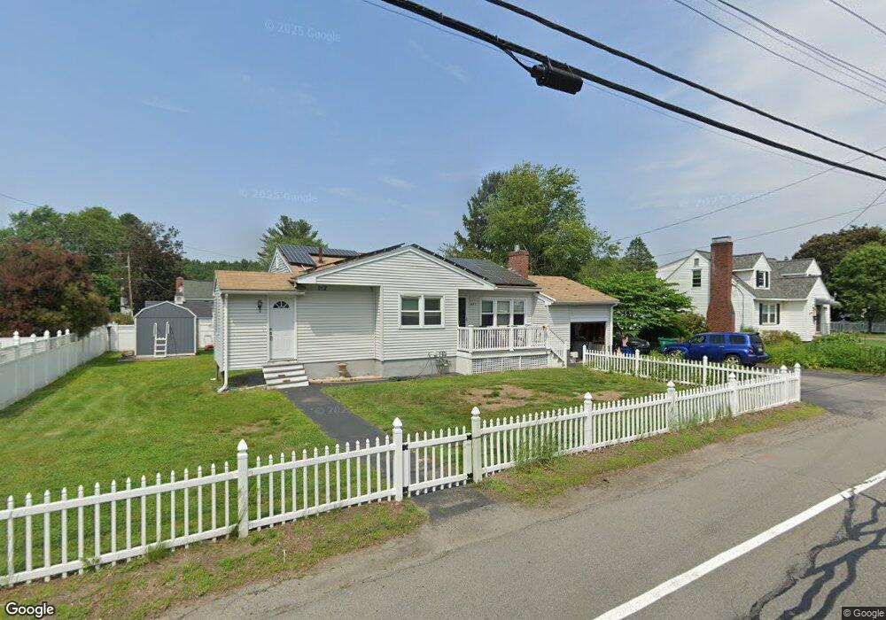
691 Varnum Ave Lowell, MA 01854
Pawtucketville NeighborhoodEstimated Value: $439,000 - $535,592
3
Beds
1
Bath
1,200
Sq Ft
$418/Sq Ft
Est. Value
About This Home
This home is located at 691 Varnum Ave, Lowell, MA 01854 and is currently estimated at $502,148, approximately $418 per square foot. 691 Varnum Ave is a home located in Middlesex County with nearby schools including Joseph McAvinnue Elementary School, Charlotte M. Murkland Elementary School, and Dr. Gertrude Bailey Elementary School.
Ownership History
Date
Name
Owned For
Owner Type
Purchase Details
Closed on
Feb 28, 2001
Sold by
Vallieres Adolphe E and Vallieres Yvette H
Bought by
Iannuzzo Robert J and Krikorian Lisa M
Current Estimated Value
Purchase Details
Closed on
May 31, 1996
Sold by
Desaulniers Paul A and Gouveia Pauline
Bought by
Vallieres Adolphe and Vallieres Yvette
Purchase Details
Closed on
Apr 13, 1990
Sold by
Desaulniers Annette
Bought by
Desaulniers Paul A
Create a Home Valuation Report for This Property
The Home Valuation Report is an in-depth analysis detailing your home's value as well as a comparison with similar homes in the area
Home Values in the Area
Average Home Value in this Area
Purchase History
| Date | Buyer | Sale Price | Title Company |
|---|---|---|---|
| Iannuzzo Robert J | $154,900 | -- | |
| Iannuzzo Robert J | $154,900 | -- | |
| Vallieres Adolphe | $103,750 | -- | |
| Vallieres Adolphe | $103,750 | -- | |
| Desaulniers Paul A | $120,000 | -- | |
| Desaulniers Paul A | $120,000 | -- |
Source: Public Records
Mortgage History
| Date | Status | Borrower | Loan Amount |
|---|---|---|---|
| Open | Desaulniers Paul A | $25,000 | |
| Open | Desaulniers Paul A | $142,400 |
Source: Public Records
Tax History Compared to Growth
Tax History
| Year | Tax Paid | Tax Assessment Tax Assessment Total Assessment is a certain percentage of the fair market value that is determined by local assessors to be the total taxable value of land and additions on the property. | Land | Improvement |
|---|---|---|---|---|
| 2025 | $5,315 | $463,000 | $178,900 | $284,100 |
| 2024 | $5,016 | $421,200 | $167,200 | $254,000 |
| 2023 | $4,780 | $384,900 | $145,400 | $239,500 |
| 2022 | $4,280 | $337,300 | $132,200 | $205,100 |
| 2021 | $4,154 | $308,600 | $115,000 | $193,600 |
| 2020 | $3,860 | $288,900 | $117,300 | $171,600 |
| 2019 | $3,740 | $266,400 | $103,300 | $163,100 |
| 2018 | $3,687 | $256,200 | $98,300 | $157,900 |
| 2017 | $3,582 | $240,100 | $89,400 | $150,700 |
| 2016 | $3,369 | $222,200 | $83,400 | $138,800 |
| 2015 | $3,356 | $216,800 | $81,600 | $135,200 |
| 2013 | $3,245 | $216,200 | $102,600 | $113,600 |
Source: Public Records
Map
Nearby Homes
- 101 Laurie Ln
- 527 Pawtucket Blvd Unit 304
- 69 Coburn Dr
- 49 Coburn Dr
- 6 Louis Farm Rd Unit 6
- 3 Louis Farm Rd Unit 3
- 307 Pawtucket Blvd Unit 13
- 70 Pawtucket Dr
- 1820 Skyline Dr Unit 18
- 20 Sandy Ln
- 1975 Middlesex St Unit 51
- 1975 Middlesex St Unit 10
- 4 Tamarack St
- 1410 Skyline Dr Unit 9
- 1710 Skyline Dr Unit 10
- 1600 Skyline Dr Unit 2
- 2200 Skyline Dr Unit 5
- 149 Woodward Ave
- 24 Brouilette St Unit A
- 770 Princeton Blvd