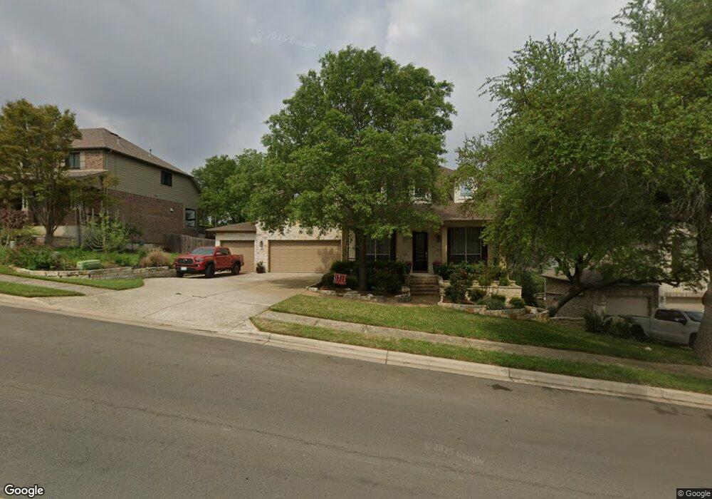
6916 Covered Bridge Dr Austin, TX 78736
West Oak Hill NeighborhoodEstimated Value: $824,000 - $986,000
--
Bed
3
Baths
3,481
Sq Ft
$253/Sq Ft
Est. Value
About This Home
This home is located at 6916 Covered Bridge Dr, Austin, TX 78736 and is currently estimated at $881,024, approximately $253 per square foot. 6916 Covered Bridge Dr is a home located in Travis County with nearby schools including Oak Hill Elementary School, Small Middle School, and James Bowie High School.
Ownership History
Date
Name
Owned For
Owner Type
Purchase Details
Closed on
Jan 11, 2008
Sold by
Wilshire Homes Lp
Bought by
Garance Jillanne J and Garance Michael G
Current Estimated Value
Home Financials for this Owner
Home Financials are based on the most recent Mortgage that was taken out on this home.
Original Mortgage
$399,000
Outstanding Balance
$250,673
Interest Rate
6.07%
Mortgage Type
Purchase Money Mortgage
Estimated Equity
$630,351
Create a Home Valuation Report for This Property
The Home Valuation Report is an in-depth analysis detailing your home's value as well as a comparison with similar homes in the area
Home Values in the Area
Average Home Value in this Area
Purchase History
| Date | Buyer | Sale Price | Title Company |
|---|---|---|---|
| Garance Jillanne J | -- | Independence Title Company |
Source: Public Records
Mortgage History
| Date | Status | Borrower | Loan Amount |
|---|---|---|---|
| Open | Garance Jillanne J | $399,000 |
Source: Public Records
Tax History Compared to Growth
Tax History
| Year | Tax Paid | Tax Assessment Tax Assessment Total Assessment is a certain percentage of the fair market value that is determined by local assessors to be the total taxable value of land and additions on the property. | Land | Improvement |
|---|---|---|---|---|
| 2025 | $12,188 | $791,793 | $164,998 | $626,795 |
| 2023 | $10,041 | $665,476 | $0 | $0 |
| 2022 | $11,948 | $604,978 | $0 | $0 |
| 2021 | $11,971 | $549,980 | $100,000 | $449,980 |
| 2020 | $10,814 | $504,159 | $100,000 | $404,159 |
| 2018 | $10,508 | $474,607 | $100,000 | $374,607 |
| 2017 | $10,171 | $456,089 | $60,000 | $396,089 |
| 2016 | $9,934 | $445,433 | $60,000 | $385,433 |
| 2015 | $8,555 | $422,960 | $60,000 | $362,960 |
| 2014 | $8,555 | $386,284 | $60,000 | $326,284 |
Source: Public Records
Map
Nearby Homes
- 8818 Moccasin Path
- 7204 Covered Bridge Dr
- 6701 Covered Bridge Dr
- 6701 Covered Bridge Dr Unit 51
- 6701 Covered Bridge Dr Unit 40
- 8737 W Highway 71
- 7324 Covered Bridge Dr
- 8536 Red Willow Dr
- 6718 Silvermine Dr Unit 804
- 6803 Silvermine Dr
- 7505 Roaring Springs Dr
- 7601 Crackling Creek Dr
- 8551 Red Willow Dr
- 8318 Gallatin Dr
- 8005 Red Willow Dr
- 7301 Scenic Brook Dr
- 6901 Bright Star Ln
- 7008 Chinook Dr
- 8622 Thunderbird Rd
- 7010 Harvest Trail Dr
- 6910 Covered Bridge Dr
- 6922 Covered Bridge Dr
- 6906 Covered Bridge Dr
- 6926 Covered Bridge Dr
- 6917 Covered Bridge Dr
- 6900 Covered Bridge Dr
- 6911 Covered Bridge Dr
- 7000 Covered Bridge Dr
- 6921 Covered Bridge Dr
- 6907 Covered Bridge Dr
- 6820 Covered Bridge Dr
- 6927 Covered Bridge Dr
- 8707 Nandas Trail
- 6816 Covered Bridge Dr
- 7001 Covered Bridge Dr
- 8817 Moccasin Path
- 8809 Moccasin Path
- 8813 Moccasin Path
- 8901 Moccasin Path
- 7019 Covered Bridge Dr