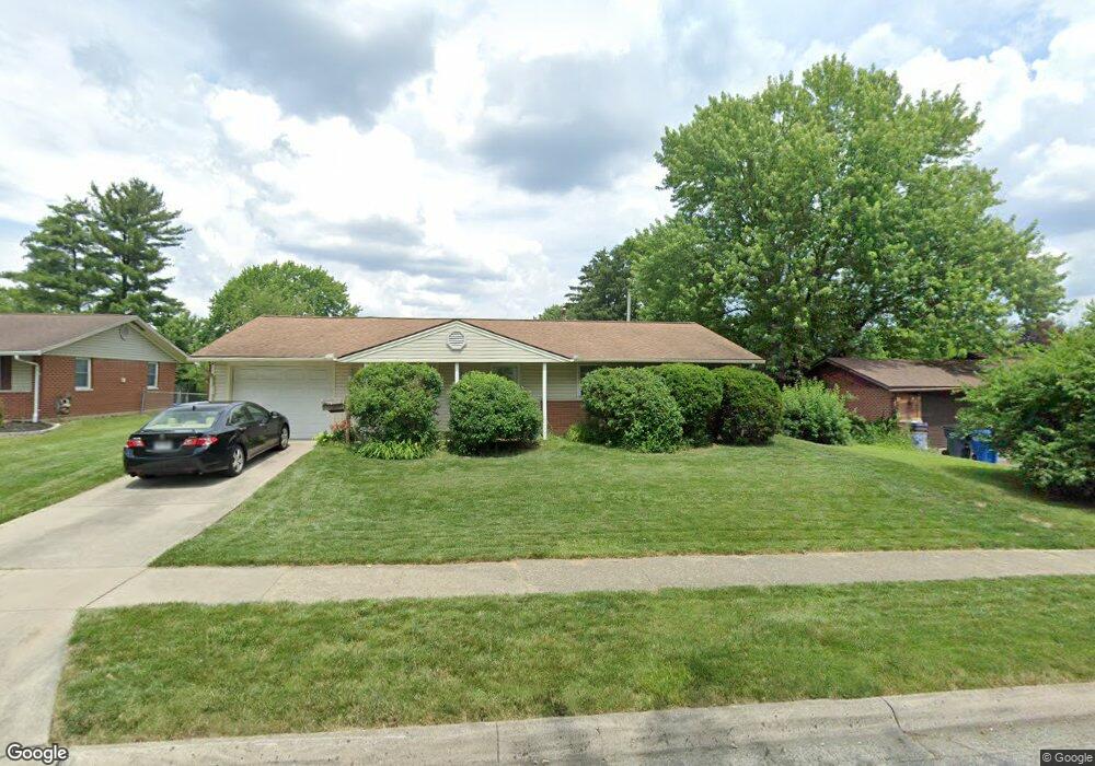
6918 Laird Ave Reynoldsburg, OH 43068
Estimated Value: $232,000 - $253,000
3
Beds
2
Baths
1,053
Sq Ft
$230/Sq Ft
Est. Value
About This Home
This home is located at 6918 Laird Ave, Reynoldsburg, OH 43068 and is currently estimated at $242,569, approximately $230 per square foot. 6918 Laird Ave is a home located in Franklin County with nearby schools including Herbert Mills Elementary School, Hannah J Ashton Middle School, and Baldwin Road Junior High School.
Ownership History
Date
Name
Owned For
Owner Type
Purchase Details
Closed on
Dec 13, 2021
Sold by
Estate Of Donna Jean Jansen
Bought by
Thompson Matthew J
Current Estimated Value
Purchase Details
Closed on
Oct 11, 2021
Sold by
Harden Philip and Atwell Leah
Bought by
Thompson Matthew J and Jansen Donna Jean
Purchase Details
Closed on
Sep 10, 2021
Sold by
Harden Philip and Atwell Laeh
Bought by
Thompson Matthew J and Estate Of Donna Jean Jansen
Purchase Details
Closed on
Feb 12, 2010
Sold by
Estate Of Fred Jansen Jr
Bought by
Jansen Donna J
Purchase Details
Closed on
Dec 13, 1962
Bought by
Jansen Fred and Jansen Donna J
Create a Home Valuation Report for This Property
The Home Valuation Report is an in-depth analysis detailing your home's value as well as a comparison with similar homes in the area
Home Values in the Area
Average Home Value in this Area
Purchase History
| Date | Buyer | Sale Price | Title Company |
|---|---|---|---|
| Thompson Matthew J | -- | None Available | |
| Thompson Matthew J | -- | None Listed On Document | |
| Thompson Matthew J | -- | None Available | |
| Jansen Donna J | -- | None Available | |
| Jansen Fred | -- | -- |
Source: Public Records
Tax History Compared to Growth
Tax History
| Year | Tax Paid | Tax Assessment Tax Assessment Total Assessment is a certain percentage of the fair market value that is determined by local assessors to be the total taxable value of land and additions on the property. | Land | Improvement |
|---|---|---|---|---|
| 2024 | $3,317 | $64,790 | $21,700 | $43,090 |
| 2023 | $3,166 | $64,785 | $21,700 | $43,085 |
| 2022 | $2,525 | $39,100 | $9,070 | $30,030 |
| 2021 | $2,600 | $39,100 | $9,070 | $30,030 |
| 2020 | $2,653 | $39,100 | $9,070 | $30,030 |
| 2019 | $1,725 | $32,380 | $7,560 | $24,820 |
| 2018 | $1,631 | $32,380 | $7,560 | $24,820 |
| 2017 | $1,724 | $32,380 | $7,560 | $24,820 |
| 2016 | $1,586 | $28,180 | $6,830 | $21,350 |
| 2015 | $1,537 | $28,180 | $6,830 | $21,350 |
| 2014 | $1,544 | $28,180 | $6,830 | $21,350 |
| 2013 | $943 | $33,145 | $8,015 | $25,130 |
Source: Public Records
Map
Nearby Homes
- 1474 Marty Dr
- 6793 Laird Ave
- 1496 Mariner Dr
- 1561 Haft Dr
- 7150 E Main St Unit B101
- 6658 Furth Dr
- 6728 Greenbush Dr
- 6772 Gilette Dr
- 1177 Matterhorn Dr
- 1080 Briarcliff Rd
- 6568 Shenandoah Dr
- 6599 Carriage Ln
- 6930 Tanya Terrace
- 0 Rosehill Rd
- 6600 Carriage Ln
- 7487 E Main St
- 7353 Wollam Ave
- 6890 Nocturne Rd N
- 6849 Roundelay Rd N
- 6810 Prior Place