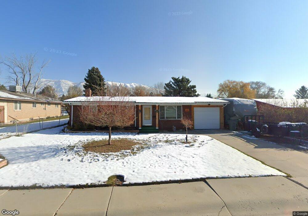
692 N 250 W American Fork, UT 84003
Estimated Value: $462,000 - $627,000
5
Beds
3
Baths
1,960
Sq Ft
$276/Sq Ft
Est. Value
About This Home
This home is located at 692 N 250 W, American Fork, UT 84003 and is currently estimated at $540,034, approximately $275 per square foot. 692 N 250 W is a home located in Utah County with nearby schools including Shelley Elementary School, American Fork Junior High School, and American Fork High School.
Ownership History
Date
Name
Owned For
Owner Type
Purchase Details
Closed on
Apr 17, 2024
Sold by
Miller Teresa C and Miller Scott
Bought by
Antoine Bunker Farms Limited Partnership
Current Estimated Value
Purchase Details
Closed on
Aug 13, 2020
Sold by
Miller Scott S and Miller Teresa C
Bought by
Miller Teresa C and Miller Scott
Home Financials for this Owner
Home Financials are based on the most recent Mortgage that was taken out on this home.
Original Mortgage
$187,000
Interest Rate
3%
Mortgage Type
New Conventional
Purchase Details
Closed on
Apr 13, 2015
Sold by
Miller Teresa C
Bought by
Miller Scott S and Miller Teresa C
Home Financials for this Owner
Home Financials are based on the most recent Mortgage that was taken out on this home.
Original Mortgage
$172,000
Interest Rate
3.7%
Mortgage Type
New Conventional
Purchase Details
Closed on
Aug 6, 2013
Sold by
Miller Teresa C and Hunter Teresa C
Bought by
Miller Teresa C
Home Financials for this Owner
Home Financials are based on the most recent Mortgage that was taken out on this home.
Original Mortgage
$15,000
Interest Rate
4.28%
Mortgage Type
Credit Line Revolving
Purchase Details
Closed on
Apr 28, 2009
Sold by
Tate Teresa C and Marcon Nan Rae
Bought by
Hunter Teresa C
Home Financials for this Owner
Home Financials are based on the most recent Mortgage that was taken out on this home.
Original Mortgage
$155,500
Interest Rate
5.02%
Mortgage Type
Purchase Money Mortgage
Purchase Details
Closed on
Oct 19, 2001
Sold by
Hanson Stanley C and Hanson Lana L
Bought by
Tate Teresa C and Marcon Nan Rae
Home Financials for this Owner
Home Financials are based on the most recent Mortgage that was taken out on this home.
Original Mortgage
$143,368
Interest Rate
6.88%
Mortgage Type
FHA
Create a Home Valuation Report for This Property
The Home Valuation Report is an in-depth analysis detailing your home's value as well as a comparison with similar homes in the area
Home Values in the Area
Average Home Value in this Area
Purchase History
| Date | Buyer | Sale Price | Title Company |
|---|---|---|---|
| Antoine Bunker Farms Limited Partnership | -- | Highland Title | |
| Miller Teresa C | -- | Gt Title Services | |
| Miller Scott S | -- | First American | |
| Miller Teresa C | -- | First American Title Company | |
| Hunter Teresa C | -- | Affiliated First Title Comp | |
| Hunter Teresa C | -- | Affiliated First Title Comp | |
| Tate Teresa C | -- | First American Title Insuran |
Source: Public Records
Mortgage History
| Date | Status | Borrower | Loan Amount |
|---|---|---|---|
| Previous Owner | Miller Teresa C | $187,000 | |
| Previous Owner | Miller Scott S | $172,000 | |
| Previous Owner | Miller Teresa C | $15,000 | |
| Previous Owner | Hunter Teresa C | $155,500 | |
| Previous Owner | Tate Teresa C | $143,368 | |
| Closed | Tate Teresa C | $565,000 |
Source: Public Records
Tax History Compared to Growth
Tax History
| Year | Tax Paid | Tax Assessment Tax Assessment Total Assessment is a certain percentage of the fair market value that is determined by local assessors to be the total taxable value of land and additions on the property. | Land | Improvement |
|---|---|---|---|---|
| 2025 | $1,895 | $270,930 | $197,700 | $294,900 |
| 2024 | $1,895 | $210,595 | $0 | $0 |
| 2023 | $1,771 | $208,615 | $0 | $0 |
| 2022 | $1,977 | $229,790 | $0 | $0 |
| 2021 | $1,688 | $306,600 | $141,900 | $164,700 |
| 2020 | $1,577 | $277,800 | $126,700 | $151,100 |
| 2019 | $1,426 | $259,700 | $108,600 | $151,100 |
| 2018 | $1,315 | $229,100 | $97,700 | $131,400 |
| 2017 | $1,308 | $122,925 | $0 | $0 |
| 2016 | $1,241 | $108,405 | $0 | $0 |
| 2015 | $1,197 | $99,220 | $0 | $0 |
| 2014 | $1,152 | $94,160 | $0 | $0 |
Source: Public Records
Map
Nearby Homes
- 782 N 200 W
- 796 N 200 W
- 540 N 300 W
- 621 N 100 W
- 641 N 420 W
- 914 N 400 W Unit A
- 3889 W 950 Cir N Unit 366
- 984 N 300 W
- 10238 N 6530 W Unit 15
- 1051 N 390 E Unit 103
- 6079 W Whisper Ln Unit 404
- 1220 E 700 N
- 1039 N 390 E Unit 102
- 11338 N Annes Way Unit 8
- 6111 W Whisper Ln Unit 402
- 183 E 760 St N
- 365 N 100 W
- 987 N 410 W
- 846 N 60 E
- 356 N 480 W