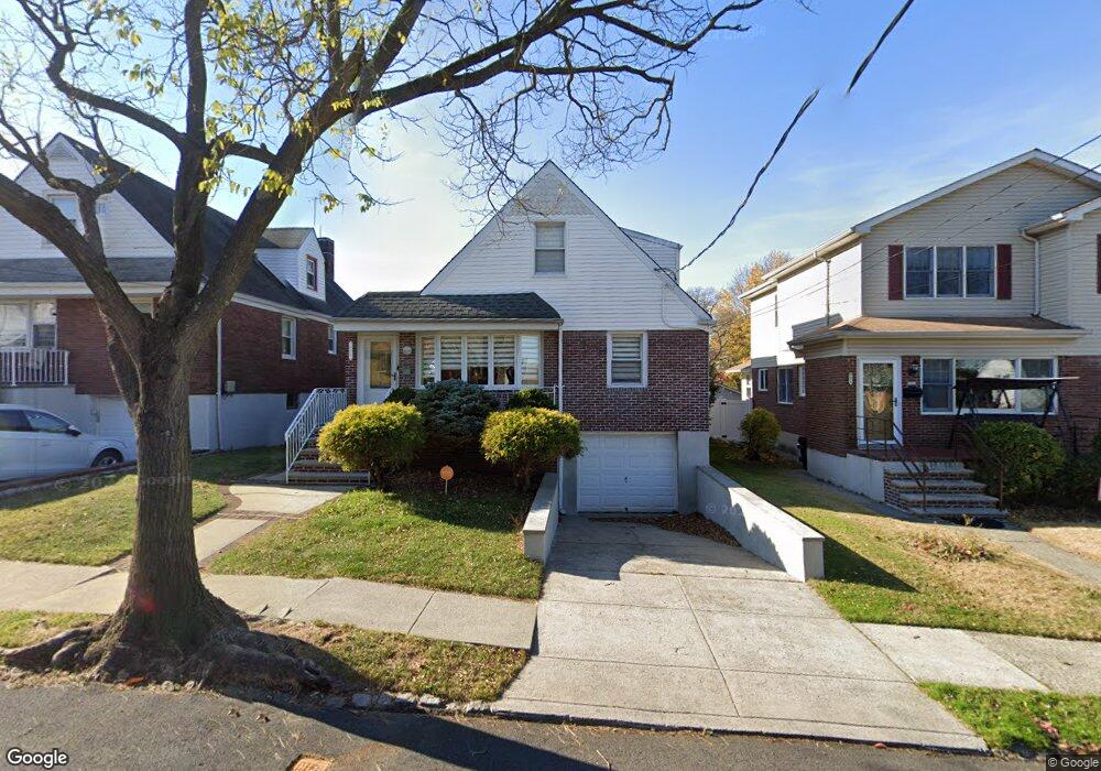
692 Pelton Ave Staten Island, NY 10310
West Brighton NeighborhoodEstimated Value: $736,449 - $912,000
--
Bed
4
Baths
1,213
Sq Ft
$682/Sq Ft
Est. Value
About This Home
This home is located at 692 Pelton Ave, Staten Island, NY 10310 and is currently estimated at $827,612, approximately $682 per square foot. 692 Pelton Ave is a home located in Richmond County with nearby schools including P.S. 45 John Tyler, Is 61 William A Morris, and Curtis High School.
Ownership History
Date
Name
Owned For
Owner Type
Purchase Details
Closed on
Sep 22, 2023
Sold by
Mazzucco Robert P
Bought by
Mazzucco Robert P and Colon-Morrow Felicia
Current Estimated Value
Purchase Details
Closed on
Dec 24, 1997
Sold by
Mazzucco Robert P and Mazzucco Sandra
Bought by
Mazzucco Robert P
Home Financials for this Owner
Home Financials are based on the most recent Mortgage that was taken out on this home.
Original Mortgage
$120,000
Interest Rate
6.5%
Create a Home Valuation Report for This Property
The Home Valuation Report is an in-depth analysis detailing your home's value as well as a comparison with similar homes in the area
Home Values in the Area
Average Home Value in this Area
Purchase History
| Date | Buyer | Sale Price | Title Company |
|---|---|---|---|
| Mazzucco Robert P | -- | None Listed On Document | |
| Mazzucco Robert P | $113,000 | -- |
Source: Public Records
Mortgage History
| Date | Status | Borrower | Loan Amount |
|---|---|---|---|
| Previous Owner | Mazzucco Robert P | $120,000 |
Source: Public Records
Tax History Compared to Growth
Tax History
| Year | Tax Paid | Tax Assessment Tax Assessment Total Assessment is a certain percentage of the fair market value that is determined by local assessors to be the total taxable value of land and additions on the property. | Land | Improvement |
|---|---|---|---|---|
| 2025 | $7,576 | $46,080 | $14,092 | $31,988 |
| 2024 | $7,588 | $39,120 | $17,109 | $22,011 |
| 2023 | $7,904 | $40,320 | $15,958 | $24,362 |
| 2022 | $7,451 | $38,760 | $15,660 | $23,100 |
| 2021 | $7,470 | $40,860 | $15,660 | $25,200 |
| 2020 | $7,492 | $42,420 | $15,660 | $26,760 |
| 2019 | $7,375 | $40,260 | $15,660 | $24,600 |
| 2018 | $6,752 | $34,583 | $14,059 | $20,524 |
| 2017 | $6,351 | $32,626 | $13,668 | $18,958 |
| 2016 | $5,843 | $30,780 | $15,660 | $15,120 |
| 2015 | $5,579 | $30,660 | $17,400 | $13,260 |
| 2014 | $5,579 | $30,660 | $17,400 | $13,260 |
Source: Public Records
Map
Nearby Homes
- 677 Bement Ave
- 710 Oakland Ave
- 152 Harvest Ave
- 751 Oakland Ave
- 100 Lawrence Ave
- 1 Whitewood Ave
- 34 Harvest Ave
- 64 Greenway Dr
- 1 Sunset Hill Dr
- 40 Greenway Dr
- 605 Bard Ave
- 706 Broadway
- 967 Bard Ave
- 20 Baker Place
- 145 Norma Place
- 26 Fairway Ln
- 966 Clove Rd Unit A
- 54 City Blvd
- 1000 Clove Rd Unit LO
- 1000 Clove Rd Unit 3G
- 688 Pelton Ave
- 696 Pelton Ave
- 684 Pelton Ave
- 700 Pelton Ave
- 665 Oakland Ave
- 669 Oakland Ave
- 680 Pelton Ave
- 704 Pelton Ave
- 657 Oakland Ave
- 675 Oakland Ave
- 693 Pelton Ave
- 689 Pelton Ave
- 695 Pelton Ave
- 674 Pelton Ave
- 683 Pelton Ave
- 699 Pelton Ave
- 651 Oakland Ave
- 681 Oakland Ave
- 679 Pelton Ave
- 705 Pelton Ave