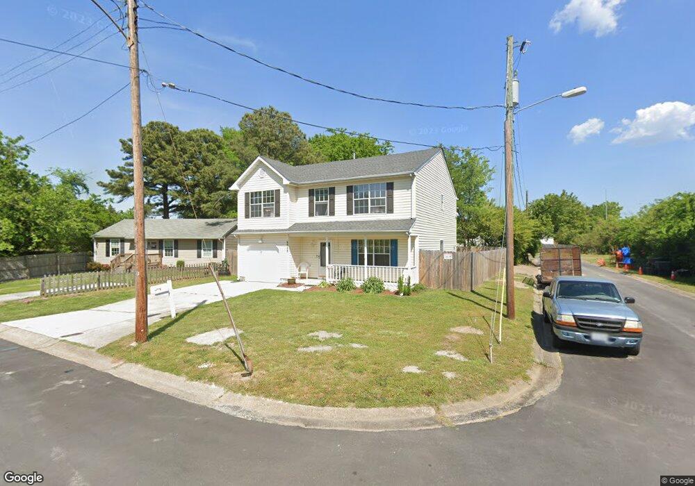
6928 Partridge St Norfolk, VA 23513
Chesapeake Gardens/Mamie Homes NeighborhoodEstimated Value: $350,000 - $381,000
4
Beds
3
Baths
2,368
Sq Ft
$156/Sq Ft
Est. Value
About This Home
This home is located at 6928 Partridge St, Norfolk, VA 23513 and is currently estimated at $368,985, approximately $155 per square foot. 6928 Partridge St is a home located in Norfolk City with nearby schools including Frances E. Willard Model Elementary School, Norview Middle School, and Norview High School.
Ownership History
Date
Name
Owned For
Owner Type
Purchase Details
Closed on
Nov 14, 2016
Sold by
Willis Montgomery and Wills Michelle M
Bought by
Fosnaught Brandy Marie
Current Estimated Value
Home Financials for this Owner
Home Financials are based on the most recent Mortgage that was taken out on this home.
Original Mortgage
$166,920
Outstanding Balance
$134,008
Interest Rate
3.42%
Mortgage Type
FHA
Estimated Equity
$234,977
Create a Home Valuation Report for This Property
The Home Valuation Report is an in-depth analysis detailing your home's value as well as a comparison with similar homes in the area
Home Values in the Area
Average Home Value in this Area
Purchase History
| Date | Buyer | Sale Price | Title Company |
|---|---|---|---|
| Fosnaught Brandy Marie | $170,000 | Preferred Escrow & Title Inc |
Source: Public Records
Mortgage History
| Date | Status | Borrower | Loan Amount |
|---|---|---|---|
| Open | Fosnaught Brandy Marie | $166,920 |
Source: Public Records
Tax History Compared to Growth
Tax History
| Year | Tax Paid | Tax Assessment Tax Assessment Total Assessment is a certain percentage of the fair market value that is determined by local assessors to be the total taxable value of land and additions on the property. | Land | Improvement |
|---|---|---|---|---|
| 2025 | $4,071 | $325,700 | $73,100 | $252,600 |
| 2024 | $3,989 | $324,300 | $73,100 | $251,200 |
| 2023 | $3,684 | $294,700 | $73,100 | $221,600 |
| 2022 | $3,415 | $273,200 | $51,600 | $221,600 |
| 2021 | $3,033 | $242,600 | $43,000 | $199,600 |
| 2020 | $2,918 | $233,400 | $37,400 | $196,000 |
| 2019 | $2,873 | $229,800 | $37,400 | $192,400 |
| 2018 | $2,776 | $222,100 | $37,400 | $184,700 |
| 2017 | $2,505 | $217,800 | $37,400 | $180,400 |
| 2016 | $2,505 | $206,700 | $37,400 | $169,300 |
| 2015 | $2,377 | $206,700 | $37,400 | $169,300 |
| 2014 | $2,377 | $206,700 | $37,400 | $169,300 |
Source: Public Records
Map
Nearby Homes
- 1041 Tifton St
- 983 Widgeon Rd
- 7021 University Dr
- 985 Wolcott Ave
- 977 Wolcott Ave
- 1044 Kane St
- 936 Widgeon Rd
- 901 Lasser Dr
- 1072 Kane St
- 955 Marietta Ave
- 974 Philpotts Rd
- 1038 Philpotts Rd
- 809 Craten Rd
- 1037 Philpotts Rd
- 837 Tifton St
- 977 Avenue G
- 6459 Clare Rd
- 943 Philpotts Rd
- 6416 Palem Rd
- 720 Nickoles Ln
- 6932 Partridge St
- 6929 Minnie Ave
- 6933 Minnie Ave
- 1017 Tifton St
- 1013 Tifton St
- 6925 Partridge St
- 1021 Tifton St
- 1007 Tifton St
- 1025 Tifton St
- 6937 Minnie Ave
- 1003 Tifton St
- 6932 Minnie Ave
- 1029 Tifton St
- 6941 Minnie Ave
- 1016 Tifton St
- 1033 Tifton St
- 1004 Tifton St
- 6905 Minnie Ave
- 6945 Minnie Ave
- 973 Tifton St