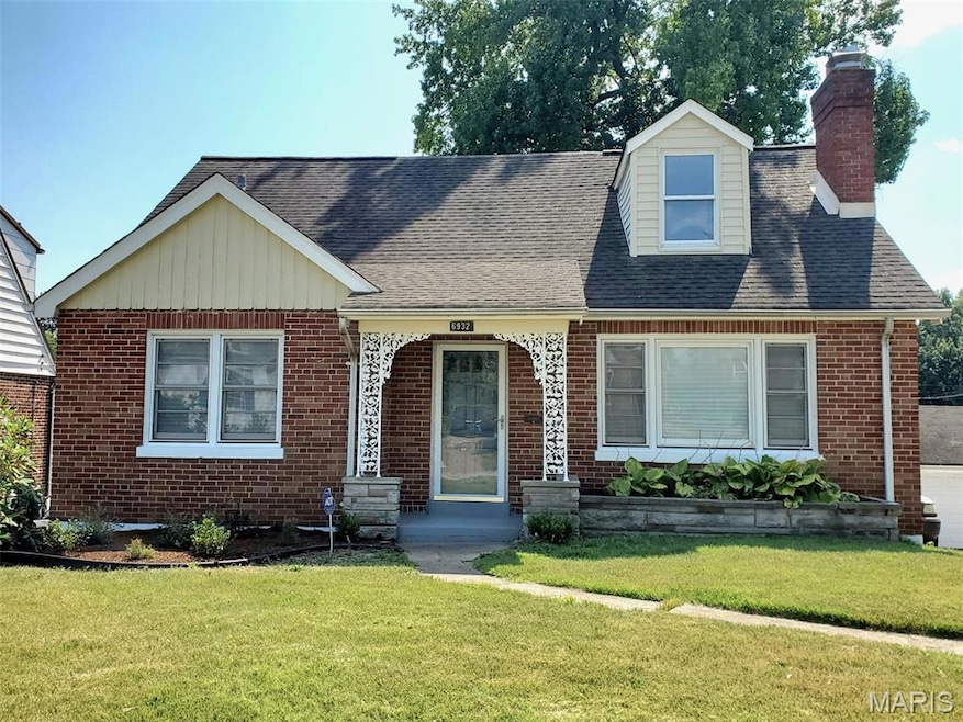
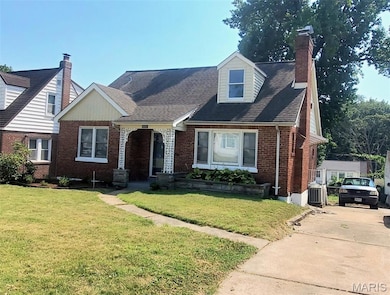
6932 Florian Ave Saint Louis, MO 63121
Estimated payment $1,050/month
Highlights
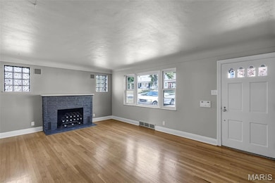
- Living Room with Fireplace
- No HOA
- Stainless Steel Appliances
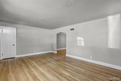
- Wood Flooring
- Formal Dining Room
- 1 Car Attached Garage
About This Home
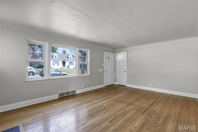
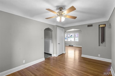
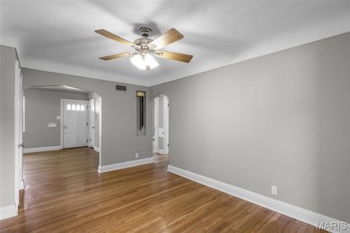
Back on the market; no fault of the seller. Please see supplemental docs for a list of updates/repairs completed on the property. The property is an inviting 3-bedroom, 2-bath, Mid-Century ranch that blends classic features with modern updates. Step inside to find bright, open living spaces featuring hardwood floors, cove ceilings and marble windowsills. The kitchen features warm wood cabinetry and stainless-steel appliances. A full walkout basement offers endless potential —whether you’re dreaming of a home office, or extra living space. Outside, enjoy a side driveway, rear entry garage and a spacious yard ideal for gardening, or entertaining. Conveniently located near parks, schools, shopping, and highways, this home is a rare find. Don’t miss the opportunity to make it yours!
Home Details
Home Type
- Single Family
Est. Annual Taxes
- $1,855
Year Built
- Built in 1951 | Remodeled
Lot Details
- 5,249 Sq Ft Lot
Parking
- 1 Car Attached Garage
- Inside Entrance
- Rear-Facing Garage
- Garage Door Opener
- Driveway
Home Design
- Brick Exterior Construction
- Architectural Shingle Roof
- Concrete Perimeter Foundation
Interior Spaces
- 1,558 Sq Ft Home
- 1.5-Story Property
- Bookcases
- Coffered Ceiling
- Ceiling Fan
- Wood Burning Fireplace
- Electric Fireplace
- French Doors
- Panel Doors
- Living Room with Fireplace
- 2 Fireplaces
- Formal Dining Room
- Wood Flooring
- Storm Doors
Kitchen
- Free-Standing Gas Oven
- Dishwasher
- Stainless Steel Appliances
- Disposal
Bedrooms and Bathrooms
- 3 Bedrooms
- Bathtub
- Shower Only
Basement
- Basement Ceilings are 8 Feet High
- Fireplace in Basement
- Laundry in Basement
Accessible Home Design
- Accessible Bedroom
- Accessible Common Area
Location
- Property is near a bus stop
- Suburban Location
Schools
- Washington Elem. Elementary School
- Normandy Middle School
- Normandy High School
Utilities
- Central Air
- Heating System Uses Natural Gas
- Cable TV Available
Listing and Financial Details
- Assessor Parcel Number 14H-32-1773
Community Details
Overview
- No Home Owners Association
Recreation
- Park
Map
Home Values in the Area
Average Home Value in this Area
Tax History
| Year | Tax Paid | Tax Assessment Tax Assessment Total Assessment is a certain percentage of the fair market value that is determined by local assessors to be the total taxable value of land and additions on the property. | Land | Improvement |
|---|---|---|---|---|
| 2025 | $1,855 | $23,390 | $2,680 | $20,710 |
| 2024 | $1,855 | $18,730 | $760 | $17,970 |
| 2023 | $1,955 | $18,730 | $760 | $17,970 |
| 2022 | $1,850 | $15,410 | $2,300 | $13,110 |
| 2021 | $1,831 | $15,410 | $2,300 | $13,110 |
| 2020 | $1,812 | $14,670 | $1,920 | $12,750 |
| 2019 | $1,795 | $14,670 | $1,920 | $12,750 |
| 2018 | $1,773 | $13,640 | $780 | $12,860 |
| 2017 | $1,758 | $13,640 | $780 | $12,860 |
| 2016 | $1,748 | $13,110 | $1,160 | $11,950 |
| 2015 | $1,719 | $13,110 | $1,160 | $11,950 |
| 2014 | $1,500 | $11,500 | $1,770 | $9,730 |
Property History
| Date | Event | Price | List to Sale | Price per Sq Ft |
|---|---|---|---|---|
| 11/03/2025 11/03/25 | Price Changed | $169,500 | -3.1% | $109 / Sq Ft |
| 09/28/2025 09/28/25 | For Sale | $175,000 | 0.0% | $112 / Sq Ft |
| 09/17/2025 09/17/25 | Pending | -- | -- | -- |
| 09/15/2025 09/15/25 | For Sale | $175,000 | -- | $112 / Sq Ft |
Purchase History
| Date | Type | Sale Price | Title Company |
|---|---|---|---|
| Warranty Deed | $69,900 | -- | |
| Warranty Deed | $69,900 | -- | |
| Interfamily Deed Transfer | -- | -- |
Mortgage History
| Date | Status | Loan Amount | Loan Type |
|---|---|---|---|
| Open | $69,351 | FHA | |
| Closed | $69,351 | FHA | |
| Closed | $5,000 | No Value Available |
Source: MARIS MLS
MLS Number: MIS25058120
APN: 14H-32-1773
Disclaimer: Certain information contained herein is derived from information provided by parties other than Homes.com. All information provided is deemed reliable, but is not guaranteed to be accurate and should be independently verified.
![]() Based on information submitted to the MLS GRID. All data is obtained from various sources and may not have been verified by broker or MLS GRID. Supplied Open House Information is subject to change without notice. All information should be independently reviewed and verified for accuracy. Properties may or may not be listed by the office/agent presenting the information. Some IDX listings have been excluded from this website.
Based on information submitted to the MLS GRID. All data is obtained from various sources and may not have been verified by broker or MLS GRID. Supplied Open House Information is subject to change without notice. All information should be independently reviewed and verified for accuracy. Properties may or may not be listed by the office/agent presenting the information. Some IDX listings have been excluded from this website.
The Digital Millennium Copyright Act of 1998, 17 U.S.C. § 512 (the “DMCA”) provides recourse for copyright owners who believe that material appearing on the Internet infringes their rights under U.S. copyright law. If you believe in good faith that any content or material made available in connection with our website or services infringes your copyright, you (or your agent) may send us a notice requesting that the content or material be removed, or access to it blocked.
Notices must be sent in writing by email to DMCAnotice@MLSGrid.com.
The DMCA requires that your notice of alleged copyright infringement include the following information:
(1) description of the copyrighted work that is the subject of claimed infringement;
(2) description of the alleged infringing content and information sufficient to permit us to locate the content;
(3) contact information for you, including your address, telephone number and email address;
(4) a statement by you that you have a good faith belief that the content in the manner complained of is not authorized by the copyright owner, or its agent, or by the operation of any law;
(5) a statement by you, signed under penalty of perjury, that the information in the notification is accurate and that you have the authority to enforce the copyrights that are claimed to be infringed; and
(6) a physical or electronic signature of the copyright owner or a person authorized to act on the copyright owner’s behalf. Failure to include all of the above information may result in the delay of the processing of your complaint.
- 6947 Groveland Dr
- 7143 Roland Blvd
- 4327 Nelson Dr
- 4731 Nelson Dr
- 4303 Nelson Dr
- 7236 S Roland Blvd
- 4207 Colonial Ave
- 7280 S Roland Blvd
- 6737 Kenwood Dr
- 4607 Fletcher St
- 6911 Reder Ave
- 6711 Daiber St
- 4709 Fletcher St
- 3833 Oakridge Blvd
- 6705 Donald St
- 6905 Alberici Ave
- 6710 Kenwood Dr
- 3815 Melba Place
- 6908 Alberici Ave
- 4610 Seattle St
- 6931 Roland Blvd
- 6949 Pasadena Blvd
- 4706 Roxie St
- 3825 Melba Place
- 3812 Avondale Ave
- 7376 San Diego Ave
- 6926 Natural Bridge Rd Unit 2
- 6605 Kahns Ave
- 6605 Kahns St
- 3438 Lucas and Hunt Rd
- 7129 Dawson Place
- 5306 Olene Dr
- 5241 Hodiamont Ave
- 5421 Bermuda Dr Unit A. 1st Flr.
- 5305 Wilborn Dr
- 5636 Sunbury Ave
- 4318 Walker Ln Unit 4348-A
- 5502 Helen Ave
- 5659 Beldon Dr
- 7008 Paisley Dr
